Perhaps Roaf's above map (1990) showing the Euphrates passing to south of Eridu and eastwards to Tell el Lahm is based on an earlier map prepared by Adams? Adams highly regarded research (1981) on ancient sites in Lower Mesopotamia possesses several maps showing a channel of the Euphrates passing to the south of Eridu and continuing eastwards towards Tell el Lahm (cf. a series of maps on pages 331, 332, 333, and 335 and compare them with Eridu's placement on the map on p. 324. Robert McCormick Adams. Heartland of Cities, Surveys of Ancient Settlement and Land Use on the Central Floodplain of the Euphrates. Chicago & London. The University of Chicago Press. 1981). The above satellite image quite clearly reveals Adams is in error, the Euphrates' southernmost channel passing to the south of Eridu ends in the sebkha basin lower than and east of Eridu it does _not_ proceed eastwards to Tell el Lahm. This scholarly "misunderstanding" by Adams and Roaf caused me, in error, to suggest the Sea of the Rising Sun associated with Dilmun was the sebkha east of Eridu and that Dilmun lay along Adam's/Roaf's Euphrates channel proceeding eastwards toward Tell el Lahm from the sebkha.
Leick on the lagoon near Eridu which she identifies with the apzu or apsu:
p. 2-3:
"...the city commanded its own ecosystem, since it was built upon a hillock within a depression about twenty feet below the level of the surrounding land, which allowed the subterranean waters to collect together. This swampy place can still become a sizable lake in the months of high water. The earliest Mesopotamian texts, from the early third millennium, underline the importance of this lagoon. In Sumerian this was known as the abzu (in Akkadian
apsu). In the almost rainless southern regions, the most obvious and crucial manifestation of water was the abzu. At Eridu, so the texts say, it surrounded the religious centre and became synonymous with it...Below the earth was the abzu...Eridu was the centre of the cult for the god or goddess of sweet water."
p.15:
"...agricultural exploitation of the Eridu region, with its cattle herding and barley fields..."
p. 16:
"In Eridu, the resources of the marshes and lagoon were prominent and the abundance of water made it suitable for the breeding of cattle and pigs. The favourite food consumed in the temple was fish, a preference perhaps induced by association with the Apsu."
p. 20:
"In the so-called Eridu Cosmogony, the primeval matter was composed of the mingled sweet and salty waters, personified as Apsu and Tiamat respectively. This echoes the natural conditions of the marsh area where brackish and fresh waters come together.
p. 22:
"The Mesopotamians also made a connection between water and intelligence, or wisdom...Eridu as the primary manifestation of the Apsu was also regarded as the place of knowledge, the fount of wisdom, and under Enki's control. Several narratives elaborate on this concept. Eridu as the storehouse of divine decrees..."
p. 24:
"Adapa...has to go fishing in the lagoon..."
p. 25:
"The seven sages were a manifestation of the ultimately unpredictable forces of the Apsu. They often appear in magic texts and incantations as the abgal (Akkadian apkallu), fish-like creatures under the command of Enki/Ea. The masks worn by some priests represented on seals and a number of Assyrian reliefs are connected with the power of the Apkallu to ward off evil. They were also personified as traditionally seven 'culture heroes', sent by Ea to teach mankind the arts of civilization. In the late Babylonian composition known as the Erra epic, they are called 'the seven sages of the Apsu, the pure paradu fish, who, just as their lord Ea, have been endowed with sublime wisdom.' They were the councillors of the antediluvian kings, also seven in number, and responsible for the invention and building of cities. The city is therefore the product of divine intelligence."
p. 26:
"...Berossus...the fish-like monsters that Ea sent after the flood to teach mankind. One of them is called Oannes, the Greek form of Adapa's Sumerian name U-an."
p. 26-27:
"..narratives about Enki and Eridu emphasize the connection between the locality, especially the Apsu, creation and fertility...Holy of Holies, Eridu Abzu, shrine, erected for its prince...watered by the Prince's canal...O Eridu...Shrine Abzu..."
p. 29:
"At Eridu the features of the landscape -especially the large body of sweet water, a sort of lagoon at the edge of the desert- were seen as manifestations of divinity...Just as the Apsu, the most potent symbol of Eridu's sanctity, could be present in any temple of the land, in analogy to the ever-present though hidden underground water-table, so Eridu was ever present and immortal, even when its ruins were covered by sand. Eridu and Mesopotamian culture have the same origin, with their fish-like creatures emerging from the primeval slime."
(Gwendolyn Leick. Mesopotamia: The Invention of the City. London. Penguin Books. 2001)
Berossus understood fish-monsters arose from "the sea" and taught man the arts of civilization. Apparently he is referring to Eridu and its lagoon which Leick apparently (?) associates with Zarins' Sebkha.
Enki in hymns speaks of his abzu shrine or sea-house as casting its shadow over a snake-marsh and a sea filled with reeds associated with a river. In other words "the sea" (lagoon/sebkha) is being fed by the river, which could be a canal as canals were called in Sumerian id which means river too. So the lagoon is apparently described variously as a Sebkha (Zarins), a freshwater Lake (Leick) and brackish marsh (Leick).
Enki in myths speaks of his Abzu house casting its shadow over a nearby "snake marsh" or "a sea," (his abzu house also being called a "sea-house"). Perhaps the Sebkha is the "Sea" and "Snake Marsh"? It is the discharge of the Euphrates' freshwater into the Sebkha which has rejuvenated it from being a "dead sea" to a "living one." I recall here the Roman geographer Strabo mentioning the "Bitter Lakes" in the Isthmus of Suez. He said at first they were bitter, but when a canal was cut under Darius (and maintained by the Ptolemies and Romans), the freshwater from the Nile brought the Bitter Lakes back to life, filling them with fish, reeds and aquatic birds. Perhaps this applies to the Sebkha adjacent to and east of Eridu?
Dilmun in texts lies at "the mouth of the rivers." Pinches (1908) noted a text that mentioned Eridu as lying between the mouths of the rivers and that Utnapistim had been settled in Dilmun "at the mouth of the rivers." Zarins' map shows a canal on the northside of Eridu called the id-gu-bi-eridu-ki-ga emptying into the NW side of the Sebkha and to the south of Eridu a channel of the Euphrates emptying into the Sebkha's W side. In cuneiform texts id could mean both river and canal? Why? In myths, the Tigris and Euphrates' river channels are dug-out by hoes wielded by the Igigi gods before man's creation then Enki of Eridu ejaculates and fills them with freshwater. So, perhaps because in myths rivers (Euphrates and Tigris) and canals were made by hoes both came to be "rivers" or "id"? If this be so, then the the "river's mouths" at Eridu are recalling the (1) id-gu-bi-eridu-ki-ga canal _and_ (2) the Euphrates' channel passing the southside of Eridu. These two "mouths of the rivers" empty into the Sebkha. A viewer in Eridu looking due east would behold the Sebkha or Lagoon as a great sea or body of water, as it is approximately 20 kilometers (12 miles) in length and 10 kilometers (6 miles) in width about the size of the Sea of Galilee in Israel.
Below, my rendering of Zarins' map which is in turn, apparently (?) his rendering based on a 1940 British one-quarter-inch equals a mile map. I have "added" data to the below map not appearing on Zarins' map. The Sebkha is about 20 kilometers in length (12 miles) and about 10 kilometers in width (6 miles). (cf. figure 1. for Zarins' map. p. 58. Juris Zarins. "The Early Settlement of Southern Mesopotamia: A Review of Recent Historical, Geological, and Archaeological Research." pp. 55-77. Journal of the American Oriental Society. Vol. 112, No. 1. Jan.-Mar. 1992)
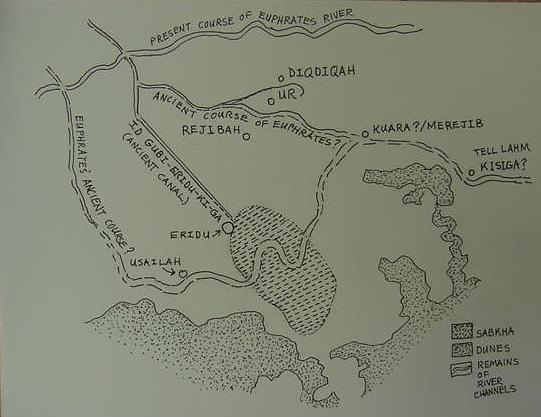
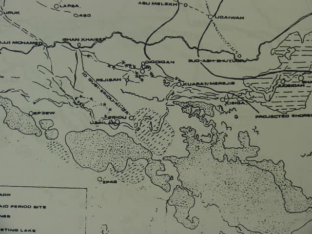
Below, Zarins' map, figure 1. page 58. Note two additional Sebkhas to the south of Eridu and the relic channel of the Euphrates, south of some sand dunes. Please compare with my above map for clarity on site names. Stippled areas are sand dunes, diagonal lines mark-off Sebkhas, parallel lines mark-off a body of water (Juris Zarins. "The Early Settlement of Southern Mesopotamia: A Review of Recent Historical, Geological, and Archaeological Research." pp. 55-77. Journal of the American Oriental Society. Vol. 112, No. 1. Jan.-Mar. 1992. Note: Zarins is in part reviewing and commenting upon a book written by Hans J. Nissen titled The Early History of the Ancient Near East: 9000-2000 B.C. University of Chicago Press. English translation of 1988).
Zarins on the Sebkha adjacent to and east of Eridu (he is speculating on the shoreline of the Arabian Gulf being nearby):
p. 60:
"In terms of southern Mesopotamia itself, how far did the Flandrian Transgression penetrate, and did Eridu, Ur and cities of the Lagash state lie on the Gulf coastline?...A map of the Eridu region (fig. 1) quickly tells us that in spite of being located in a low-lying depression southwest of Ur, and eight-meter scarp of the Upper Fars formation (the Hazim) runs well to the north and south...possibly blocking any marine infilling into the depression...While a marsh/riverine environment was exploited at Usaila (EP 104) west of Eridu, there is no basis for suggesting either of these two sites lay on a river channel or seashore. By late Ubaid times (Ubaid 3-4), it is clear that Ur lies on a major Euphrates channel (Wright 1981:fig. 17), and a series of sites northwest of Eridu could be interpreted as forming a possible southern channel. Unfortunately no sites have been found to link Eridu eastward to Merejib (EP 29), and again we cannot be sure that a river link existed between Eridu and the Ur-Merejib channel (fig. 1)
...An actual southern channel of the Euphrates running through or by Eridu in fact is not shown on Wright's maps until the Isin-Larsa period (Wright 1981:figs. 20-21) and was in intermittent use through the Parthian period...
From the literary texts the clear and constant link is between the term ABZU and the shrine/city of Eridu. They may be used almost interchangeably (Green 1975: 154). In most cases, ABZU/apsu may be translated as "an expanse of water" (ibid. p. 163), but of what type is not clear. Most likely it was not a swamp, and the only life living in it were mythological fish-like creatures. Does the term refer to the sea? The characteristics suggest a large deep expanse of water, but some have suggested it meant subterranean aquifer waters (summary Green 1975:164-67; Safar, Mustafa and Lloyd 1981:33-34) or a Hor al Hammar-type body of water in the vicinty of Eridu.
p.61:
Associated springs are mentioned in the literary accounts as well as seepages of bitumen (Green 1975: 167-68). The ceremonial boats journeying from Eridu to Uruk are mentioned as being caulked with bitumen. Thus, the translation of ABZU as 'Marine sea' or 'freshwater lake' is still debated (Green 1975: 164, 172-73)...Taken as a whole, the following reconstruction can be suggested. The Eridu depression, like others found
p. 65:
in the Arabian desert to the west, was a locale of a fresh-water lake, active during the Pleistocene and early Holocene...not a Euphrates channel...The earliest settlements, Eridu and Usaila, were on the shores of this lake. My brief examination of the region in 1971 suggested an inland sabkha characterized by the presence of extensive shell litter and eroding black, marsh-like deposits (see also Campbell Thompson 1920:124; Weight 1981: 323)...The entire Ubaid-Early/Middle Uruk sequence of occupation at Eridu can be seen as exploiting the lake resources. Following the Early/Middle Uruk period, ca. 3700-3400 B.C. the lake area was entirely abandoned, presumeably due to aridity, and became a sabkha (Jacobsen 1957: 98; Green 1975: 19-20).
The site, however became a shrine or pilgrimage center tied to the Euphrates river channel by a large offtake canal near Ishan Khaiber running through Rejibah (Wright 1981: 326-27 and fig. 18). This evidence can be supported both by buildings in the Eridu vicinity (Safar, Mustafa and Lloyd 1981: 273-304) and royal inscriptions mentioning Eridu...Numerous Isin and Larsa kings (1953-1763 B.C.) are associated with the site (see below), most likely in light of rejuvenated river system in the area (for the later ritual Sumerian accounts, see Green 1975; Jacobsen 1960: 180-83).
The presence of a major lake, perhaps fed by western tributaries as well as the Euphrates overflow, does not preclude the proximity of a marine shoreline. I would suggest that the Hazim was in place and that the cliffs represented an effective deterrent to a major marine transgression into the Eridu lake basin. However, the shoreline was near Ur, and followed a northward extension to the proximity of ancient Girsu and Amara as suggested by Larsen and others. Marine shells have been found in Eridu Ubaid deposits...
In sum, the evidence from the Eridu depression suggests that initial occupation was along a lacustrine shoreline and that by 5000 B.C. the initial Flandrian Transgression the sea was in the vicinity of Ur. By the middle of the fourth millennium B.C., dessication had set in and caused abandonment of the site.
p. 67:
"A major southern channel of the Euphrates appears around 2000 B.C. passing by what was once Eridu (Safar, Mustafa and Lloyd 1981: 32 and fig. 2). No natural water source had been reported in the region since mid-Uruk times.. Presumably the channel appears well upstream of Ur from Uruk (or from modern Samawa. cf. Adams 1981: fig.6). This channel, possibly following an old Pleistocene bed, was established and maintained from the Isin-Larsa period through Parthian times. In contrast, the Ur branch became a minor stream and was used with difficulty (Wright 1981: 330-36; figs. 21-24). What was the stimulus for this change?...The Isin-Larsa invaders...turned out to be the chief patrons! Water may have been diverted for the Eridu channel, since it was more important for people inhabiting the southern desrt, the "sealands," and those creating new commerical ties with Dilmun."
(Juris Zarins. "The Early Settlement of Southern Mesopotamia: A Review of Recent Historical, Geological, and Archaeological Research." pp. 55-77. Journal of the American Oriental Society. Vol. 112, No. 1. Jan.-Mar. 1992. Note: Zarins is in part reviewing and commenting upon a book written by Hans J. Nissen titled The Early History of the Ancient Near East: 9000-2000 B.C. University of Chicago Press. English translation of 1988).
Mention is made in ancient texts of two interconnecting (?) lagoons near Eridug (Eridu) one of which is called a small lagoon where a Heron lays her eggs:
"She laid eggs in Enki's interconnecting (?) lagoons. She laid eggs in the smaller lagoon, the lagoon of Eridug. She laid eggs in Enki's barbar reeds."
(p. 237. "The heron and the turtle." Jeremy Black, Graham Cunningham, Eleanor Robinson, and Gabor Zolyomi.
The Literature of Ancient Sumer. Oxford University Press. 2004, with corrections 2006)
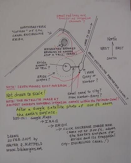
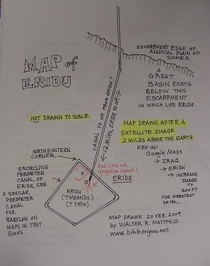
Below, a map of Eridu (Sumerian: Eridug) made by myself after a satellite image. Encircling two mounds or tells appears a great trapzoidal wall (?). Is this the remains of a "perimeter canal"? At 200 feet above the earth's surface the satellite reveals traces of what appear to be numerous smaller irrigation canals everywhere within the perimeter canal (?). Was this canal system in place in antiquity? If it was, what an amazing feat of ancient man! The perimeter canal (?) is intersected on its east side by a canal heading for Ur, where Abraham lived according to the BIble. The canal enters the great floodplain of Lower Mesopotamia and passes to the west of Ur. South of the escarpment is a great basin in which lies apparently Eridu. I have never seen an archaeological map of Eridu so I am "assuming" the trapzoidal perimeter canal (?) was an ancient feature. Supposedly Eridu was abandoned around 600 B.C. If you go to Google, click on Google Maps, then key-in Iraq, then after the Iraq map appears key-in Eridu, then use the plus or minus buttons for for the satellite map to see Eridu from 2 miles above the Earth's surface to 200 feet above the Earth's surface. My maps are _not_ drawn to scale. I have found no detailed map of Eridu showing its canals and mounds on the internet so I am posting here my drawings based upon the satellite images. Warning: I am not sure if this trapzoidal perimeter is a canal or modern highway or, if it is ancient or not! If anyone knows what this unusual trapzoidal feature is please advise me via e-mail by clicking here, thanks!
A "mighty enclosure" or "girdle of the deep" is alluded to at Eridu. Is this the trapzoidal canal acting as a fortress wall of water?
line 41. "In the the mighty enclosure, the girdle of Eridu which is to be praised...
line 56. (in) the enclosure of Eridu.
line 57. (In) the mighty girdle of the deep and of Eridu..."
(pp. 145-146. A. H. Sayce. "Accadian Poem on the Seven Evil Spirits." Records of the Past, being English translations of the Assyrian and Egyptian monuments. London. Samuel Bagster & Sons. Society of Biblical Archaeology. 1877)
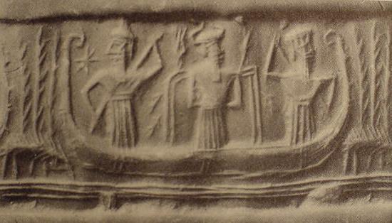
Enki of Eridu navigated his boat "downstream" from Eridu (?) to Dilmun through a marsh to seize maidens on a riverbank at Dilmun. Enki is described as keeping "one foot in his craft and the other on a river bank" when he accosts Dilmun's maidens from his boat. That is to say this suggests his boat is quite small in order to pull this feat off. Below, a picture or photo of a cylinder seal impression showing Enki (with two streams of water erupting from his shoulders with fish above them) in a small shallow boat being propelled in a marsh lined with reeds by two of his servants using punting poles, fish leap from the water, greeting him. Is this the boat he accosted Dilmun's maidens from? He is portrayed in the story as informing his servant in his boat of his intention to make love to the maiden standing at Dilmun's river bank and his servant tells him this is a great idea, "do it"! The below craft, due to its smallness and shallow draft strikes me as being inappropriate for him to sail 300 miles in across the Persian Gulf to faraway Bahrain.
Below, a photo of a mudflat's remains at the base of the Eridu Ziggurat mound (picture taken 05 June 2008). Could this mudflat area 2500 years ago have been "a part" of Eridu's marshlands and lagoons mentioned in cuneiform texts? Please click here for more photos of Eridu.
Below, a picture, an aerial photo (taken 05 June 2008) of the Eridu Ziggurat mound (there are 7 mounds at Eridu, the below photo is of only one of these mounds). The ancient texts speak of Eridu's abzu shrine casting its shade over the marshlands and lagoons which abounded with reeds, fish, turtles and herons. The lagoon area was metaphorically called a "sea" in that the abzu shrine cast its shade over the "sea."
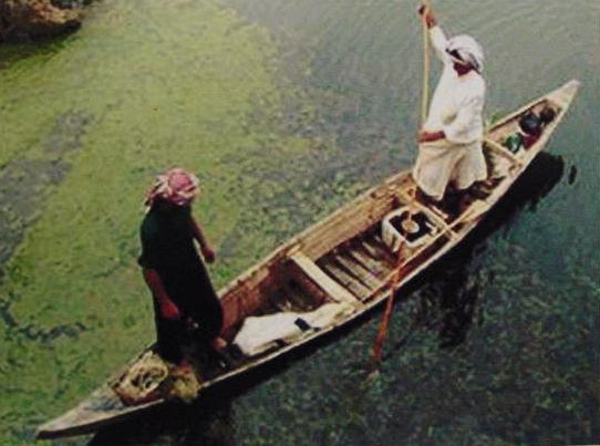
Below, a photo of a modern day descendant of Enki's above shallow-draft marsh boat, a craft totally inappropriate to travel 300 miles in across the Persian Gulf to Bahrain which many scholars associate with Dilmun despite its having no river bank or marshes and reeds.
Please click here for my article identifying Eridu as one of several pre-biblical prototypes for Genesis' garden of Eden.
Please click here for my article identifying Eridu as one of the pre-biblical prototypes for Genesis' city of Enoch in the land of Nod built by Cain who slew his brother Abel.
Black, et al, notes Enki's shrine is described as being in the midst of marshes fed by a rising river and his boat possesses a "tow rope" to get him upstream via the Euphrates to Nibur (Nippur) where dwells the god Enlil. This hymn suggests the Euphrates provided water for Eridu's marshes and lagoon and it can be navigated using a tow rope to pull a craft upstream to Nibru/Nippur. The marshes are apparently being called a "sea":
p. 330:
"Enki, god of wisdom, was the god of the freshwater ocean, the Abzu or Engur which was believed to exist under the land. His primary temple was thus at Eridug deep in the marshes in the far south of Mesopotamia..."
p. 332:
"Enki's beloved Eridug...Abzu, life of the land, beloved of Enki! Temple built on the edge...Eridug, your shadow extends over the rising sea! Rising sea without a rival; mighty awe-inspiring river which terrifies the land! E-Engur, high citadel (?) standing firm on the earth! Temple at the edge of the Engur which bestows wisdom on the land...Eridug...floats on the water. His shrine spreads out into the reed beds; birds brood in its green orchards laden with fruit. The suhur carp play among the honey-herbs, and the estub carp dart among the small gizi reeds...The Euphrates rises before him...His punting pole is Nirah; his oars are the small reeds...His ship departs...with tow rope...he leaves the temple of Eridug, the river gurgles to its lord...He directed his steps..to Nibru and entered the shrine of Nibru..."
(Jeremy Black, Graham Cunningham, Eleanor Robinson, and Gabor Zolyomi. The Literature of Ancient Sumer. Oxford University Press. 2004, with corrections 2006)
Professor Potts (1997) on the term 'sea' being applied by the ancients to marshlands or swamps with their lagoons as well as the open sea of the Persian Gulf and thus it is an error to think Ur and Eridu which are described as near a 'sea,' are implying the Persian Gulf, instead 'the sea' is actually an area of lagoons and marshes:
"The same caveats noted by Waetzoldt must also be applied to the accounts of Sennacherib's campaign against Elam in 696 B.C., according to which 'ships of my warriors reached the swamps at the mouth of the river where the Euphrates carries its waters into the fearful sea'...In all these cases, however, whether Ur and Eridu in the third millennium, or the expedition of Sennacherib against Elam, references to 'the sea' must be treated cautiously. Not only has Waetzoldt shown that, in early sources, the same terms are used for marsh/swamp and open water, but more recently S.W. Cole has demonstrated clearly that a large marsh around the site of Borsippa, southwest of Babylon and far from even the northernmost line of the Gulf, projected by de Morgan or Larsen, was routinely called the 'sea' (Akkadian tamirtu) in texts dating to the Neo-Assyrian, Neo-Babylonian and Achaemenid periods (Cole 1994:81-109). Clearly, therefore, references to 'the sea' are ambiguous and must be examined more closely in conjunction with other types of evidence before they are taken to refer to the open waters of the Gulf itself. Indeed, this point is brought home forcibly by the very designation of southernmost Mesopotamia from the early second millennium B.C. onwards."
(p. 36. "The Progradation of the Tigris-Euphrates Delta." pp. 30-41. D. T. Potts. Mesopotamian Civilization: The Material Foundations. Ithaca, New York. Cornell University Press. 1997)
Potts' warning that "sea" can apply to marshland and lagoons perhaps explains why Enki's abzu shrine is called a "sea-house" casting its shadow over "the sea." Texts mentioning Eridu as being at the sea's shore are alluding to the marshes and lagoons about Eridu, not the Persian or Arabian Gulf (Zarins in error thinking the northern shore of the gulf is near Ur).
Potts dismisses the notion that the northern shore of the Gulf was at Eridu and Ur (note: Zarins' attempt to find the northern shore of the Gulf at Eridu and Ur in his article of 1992 appears to be contested by Potts' 1997 article which follows, below).
Potts (1997) on Georges Roux's discoveries (1960) near the Hor al-Hammar Lagoon:
"In cuneiform sources southernmost Mesopotamia was known as mat tamti(m) (Sumerian KUR A.AB.BA), the 'Sealand'...While B. Meissner could claim in 1920 that the lack of mounds in this region made it certain that it had been under water (Meissner 1920:4), G. Roux's survey of the Hor al-Hammar (fig. 1.17) showed that this was purely the result of insufficient exploration (Roux 1960:30), for there is in fact a string of mounds 'extending in an almost straight line from Tell Lahm to a point 23 miles north of Basrah' which, Roux suggests 'provides a strong argument against the classical theory according to which the whole of this region was under sea-water from prehistoric times to the dawn of the Christian era' (Roux 1960:30). The existence of sites such as Tells Kirbasi, al-Lahm, Aqram and Abu Salabikh in the area of the modern Hor al-Hammar underscores the fact that, from at least the early second millennium B.C. onwards, this was a populated area which, while it may have been marshy, was certainly not submerged beneath the Gulf. Rising no more than 2 meters above the water line, Tell Kirbasi is today periodically surrounded by water, yet it is difficult to imagine that a site like this was located on an island in the Kassite period, for there is little reason to suppose that if this were the case, Tell Kirbasi or indeed the Sealand generally would have been cited as a source of cattle and cereals. Thus, de Morgan's suggested shoreline in the time of Sennacherib would place under water sites such as Tell al-Lahm which we now know were occupied during the Neo-Assyrian period! The discovery of a cylinder of Nabonidus (555-539 B.C.) at Tell al-Lahm...moreover, confirms that 150 years after Sennacherib's time, the region was most definitely not submerged, and indeed Sanlaville's sea-level curve shows that sea-levels throughout the second millennium B.C. were only marginally higher (less than 1 meter) than they are today, while from the Neo-Assyrian through the latter part of the Parthian era, they were, contrary to de Morgan's belief, significantly lower than modern levels.
That is not to say, however, that the entire area of southernmost Mesopotamia was dry land, or that references to 'the sea' in Sennacherib's account or in texts relating to Ur and Eridu do not refer to some inland body or bodies of water which actually existed...more recently Adams has suggested, 'We may have to deal in in the past, as to a lesser extent we still do today, not with a well-defined shoreline but with a progression of swamps and more and more open, more brackish or saline lagoons' (Adams 1981:16). Nevertheless, this does not necessarily mean that the Hor al-Hammar itself existed when the sites found by Roux were inhabitated. As Roux himself remarked, the existence of relict canals near Tell Abu Salabikh and a well at Tell Aqram suggest that this region was once cultivated, as indeed the Kassite cuneiform sources cited above confirm, and drier than it is today." (pp. 37-38. Potts)
"Finally, had the Gulf actually reached the area of Ur, Eridu or Tello, one must ask whether these sites could have then existed. W. Nutzel has noted that the tidal pattern in the northern Gulf affects the waters of the Shatt al-Arab in that salt-waters enters it at least as far as Abdul Khasib, circa 10 kilometers east of Basra. The interchange of salt and sweet water would have made irrigation from such water impossible, for none of the staple cereals grown in antiquity would have been able to tolerate water with such a high salt content. Therefore, settlements must always have been situated outside the zone affected by such an interchange. The very existence of sites like Ur, or for that matter, the mounds discussed above in the Hor al-Hammar district, Nutzel argues, precludes the possibility that salt-water was present in close proximity to them (Nutzel 1980:98-9)." (p. 39. D. T. Potts. Mesopotamian Civilization: The Material Foundations. Ithaca, New York. Cornell University Press. 1997)
The 1911 Encyclopedia Britannica on Eridu lying in the midst of a great valley, formerly an inland sea (brackets [ ] and emphasis in CAPITALS are mine):
"...Eridu...called by the natives Abu Shahrein, a few miles south-south-west of Moghair, ancient Ur, nearly in the centre of the dry bed of an inland sea, a deep valley, 15 miles at its broadest, covered for the most part with a nitrous incrustation, separated from the alluvial plain about Moghair by a low pebbly, sandstone range called the Hazem, but open toward the north to the Euphrates and stretching southward to the Khanega wadi below Suk-esh-Sheiuk. In the rainy season this valley BECOMES A SEA flooded by the discharge of the Khanega; in the summer the Arabs dig holes here which supply them with brackish water..T. K. Loftus (1854) and J. P. Peters (1890) both report having seen it [Eridu] from the summit of Moghair. The latter states that the Arabs at that time called the ruin Nowawis and apparently no longer knew the name Abu-Shahrein...It was, in fact, an island city in an estuary of the Persian Gulf...on the shore of the sea" as the old records aver."
Professor Langdon (1921) thought Eridu might be a part of Dilmun and he made the same observation again in 1931, please scrolldown for it (brackets [ ] are mine):
p. 64:
"Perhaps in the most ancient geography, Eridu was included in Dilmun."
"We know...the city [Eridu] actually stood beside the Euphrates."
"The Sumerian name of the Euphrates, Buranun, "Basin of the Prince," also proves the prehistoric connection between Enki of Eridu and the Euphrates."
Eridu Hymn lines: (note zu-ab is today rendered ab-zu)
22. "its foundation on the nether-sea [zu-ab-ge] is filled in."
23. By the river [id] of Sippar [Zimbir] it dwells.
33. Enki lord [lugal] of the nether-sea [zu-ab-ge]...
69. to construct the stage tower 'mountain of the land'...
70. beside it the fish pool was placed.
71. the beautiful garden was laden with fruit...
74. the gud-fish of the reeds in great numbers beget...
75. Enki his floods...
76. From the nether-sea [zu-ab] hath caused to return
77. the reservoir a mighty flood...
78. Like the sea he...
80. on the river [id] of Sippar [Zimbir] he....
(p. 64. Stephen Herbert Langdon. "A Hymn of Eridu." Journal of Oriental Research. Vol. V. Oct. 1921. Chicago)
My notes on Langdon (1921):
If buranun is correctly translated as "basin of the prince" might this apply to the basin or valley Eridu lies in rather than the Euphrates? The above hymn usually speaks of the Euphrates as being "the river of Sippar" (a town north of Nippur where the Euphrates as a single stream subdivides into four channels as it crosses the floodplain) not buranun.
Are Enki's "floods" allusions to the torrents in the rainy season from Wadi Khanega filling the valley or basin Eridu is located in the midst of? Alternately a flooding Euphrates via its canal or channel could cause flooding in the valley/basin Eridu is in. A canal did connect Eridu to the Euphrates and one could by using a tow-rope get a boat upstream against the Euphrates' current to Nippur (Nibru) north of Eridu. The Eridu canal would also provide year-round freshwater to the 15 mile-wide basin or valley Eridu is located in, providing it with reeds, fish, birds, and turtles as appear in the Enki hymns.
Leick (cf. above, 2001:26-27), mentions Eridu's canal being called the id nun "canal of the prince" and an ideogram or sign rendered Nun being used as an alternate name for Eridu, Nun-ki, perhaps (my speculation) the "land" (ki) of Nun,"? the sign nun resembles either a reed or a tree. So perhaps buranun is the "basin of nun"? The basin that nun (Eridu) sits in? id nun is the canal of nun (the canal of Eridu)? I am _not_ a trained Assyriologist or Arabic scholar so these are only "amateur speculations."
According to Peters (1890) the Arabs of his day knew Eridu as Nowawis, not Abu Shahrein. Is it possible that these are two alternate names of Eridu appearing in cuneiform texts?
According to Professor Kramer sometimes the last consonant in a Sumerian word is amissable, not pronounced, if nun was pronounced nu could Arabic Nowawis be Nu (Nun)? The "-is" would be an Arabic sufformative, giving us Nowaw, or Nu/Nun?
Abu Shahrein/Shahrain, "might" preserve Esirra, another name in cuneiform texts for the abzu shrine at Eridu. If "-in" is another Arabic word sufformative we would have shahre/shahra = [e]sirra? Has Arabic preserved in a much garbled and modified form two ancient names associated with Eridu: Nun and Esirra? Abu might preserve cuneiform abubu meaning "inundation" or "flood" the area does flood periodically in the rainy season according to the 1911 Encyclopedia Britannica article on Eridu and hymns to Enki mention a flooding river at Eridu (is the "flooding river" alluding to Wadi Khanega flooding periodically the area?).
Nituk-ki was an alternate rendering by scholars of signs for Dilmun. I am unaware of this word being possibly being preserved in some garbled or morphed manner in Arabic. However Tel al-Lahm strikes me as perhaps preserving Dilmun/Tilmun with again an amissable last consonant not being pronounced or preserved?
Potts has convinced me that Zarins is wrong, the northern shore of the Persian or Arabian Gulf was never as far north as Ur. The mention of "seas" as marshes and lagoons in ancient texts explains why some scholars (like Zarins and earlier scholars since 1880) mistakenly thought the "sea" in Eridu and Ur texts might be the Persian Gulf. Eridu's "sea" was a lagoon or marsh. Ur, Larsa, Lagash also have a "sea shore," apparently because of different lagoons in their vicinity. If a lagoon was metaphorically called a "a sea" as noted by Potts and Cole then there was _no_ great sea shore extending from Eridu to Ur, Larsa and Lagash, their "sea shores" were _individual lagoons_ being fed by various channels and canals of the Euphrates river.
Professor Langdon (1931) on Dilmun's location being the vicinity of the mouth of the Euphrates at Eridu:
"Dilmun. This is the well known land mentioned in historical texts...Dilmun must have included Eridu at the mouth of the Euphrates in mythology and Dilmun was the Sumerian land and garden of Paradise."
(pp. 193-194. Stephen Herbert Langdon. The Mythology of All Races, Semitic. Vol. 5. Boston. Archaeological Institute of America. Marshall Jones Company. 1931)
Safar who excavated at Eridu in 1948 suggested a canal existed to the SW of the city and noted some mounds near it. This statement seems to recall the mounds appearing on Zarins' map to the SW of Eridu but Zarins understands they are near a branch of the Euphrates not a canal. If Safar is correct that the canal is only 3 kilometers to the SW of Eridu, then Zarins' map may be in error in locating a canal to the N of Eridu?
"The mounds were found to lie on the banks of the bed of a wide canal which, in ancient times, was undoubtedly connected with the river Euphrates. The recognition of this canal and the tracing of its course are now extremely difficult, as it has been filled with sand and soil drifted in from the surrounding plain. The course of the canal crosses the flat depression of Eridu from north-west to south-east and its nearest point to Eridu is about 3 kilometers from the south-west of that site."
(Fuad Safer. Sumer Volume 6 (1950). p. 28)
Professor Jacobsen suggests Dilmun's geographical setting is _not_ Bahrain or Failaka but rather near the mouth of the Euphrates in the marshlands east of Sumer:
"Izin has not yet been identified. The mention of bollards indicates that it was a harbor city, and the fact that Dilmun's fresh water came from there suggests a position on the Euphrates, perhaps near the outlet..."
(note 4. p. 182. "Enki and Ninsikila/Ninhursaga." Thorkild Jacobsen. The Harps That Once...Sumerian Poetry in Translation. New Haven & London. Yale University Press. 1987. paperback)
Professor Sayce understood that in antiquity, the mouth of the Euphrates was NOT near Qurnah, it was at Eridu, which was described as at the shore of the sea. While a "mouth" of the Euphrates did exist near Eridu, this mouth ended in the Sebkha east of and lower than Eridu. The Sebkha was apparently being called in the ancient a "sea." And in the rainy season it becomes a freshwater "sea" the size of the "Sea of Galilee" in Israel. But it dries up by the summer's end. So Sayce, and others are wrong, the Persian Gulf was never at Eridu. The ancient texts are calling the Sebkha metaphorically "a sea." Eridu was not a "sea port" city. It was a dead end in a great basin, depression or hollow in the earth as revealed by satellite photos.
"The SEAPORT of primitive Chaldea was Eridu, "the good city", now Abu-Shahrein, WHICH STOOD _NEAR THE MOUTH OF_ THE EUPHRATES.
"
(p. 643. Vol. 1. A. H. Sayce. "Eden." James Hastings. A Dictionary of the Bible. T. & T. Clark. Edinburgh. 1898)
"In the distance, AT THE MOUTH OF THE RIVERS, Utnapishtim shall dwell.
So they took me and caused me to dwell in the distance, AT THE MOUTH OF THE RIVERS."
(p. 88. "The Gilgamesh Epic." Alexander Heidel. The Gilgamesh Epic and Old Testament Parallels. Chicago. University of Chicago Press. 1946, 1949, reprint of 1993. paperback)
Pinches "quotes" Sayce who renders "MOUTHS of the rivers" while Pinches renders "MOUTH of the rivers" (cf. Pinches, p. 73, pi narati...kilallan):
"ERIDU...BETWEEN THE MOUTHS OF THE RIVERS (which are) on both sides."
(p. 71. "From the Creation to the Flood." Theophilus G. Pinches. The Old Testament In the Light of the Historical Records and Legends of Assyria and Babylonia. London. The Society For Promoting Christian Knowledge. 1908)
Professor Pinches (1908) noted that Professor Sayce's mention of "river mouths on either side of Eridu" seemed to echo a similar terminology describing Dilmun's location at "the mouth of the rivers":
"The expression, "the mouth of the rivers [that are on] both sides" (pi narati...kilallan), recalls to the mind the fact, that it was to "a remote place AT THE MOUTH OF THE RIVERS" that the Babylonian Noah (Pir-napishtim) was translated after the Flood, when the gods conferred upon him the gift of immortality."
(p. 73. Theophilus G. Pinches. The Old Testament In the Light of the Historical Records and Legends of Assyria and Babylonia. London. The Society For Promoting Christian Knowledge. 1908)
The Flood hero when asked by the citizens of Shuruppak why he was building a large boat told them the god Enlil was angry with him so he was going downstream to live with Enki at the Abzu, which is associated with the Abzu shrine at Eridu. The Euphrates southernmost "mouth" in antiquity was at Eridu, it discharging its waters into the nearby lagoon or marsh. Is Dilmun, where the Flood hero was later taken to after the Flood, near the Abzu (Eridu) he was heading for in his boat? His boat was boarded after the flood by Enki of Eridu, who plead on his behalf against Enlil, who was angry that any mortal had survived the Flood, and Enki had visited Dilmun on numerous occasions via a river, gliding DOWNSTREAM through a marsh. Obviously, for me, to glide "downstream" through a marsh to Dilmun's river bank and accost Dilmun's maidens means that Dilmun is _downstream_ from Enki's principal residence at Eridu.
Is Professor Sayce's "mouths," of the rivers "that are on both sides [of Eridu]" an allusion to the canal on Eridu's northside and Euphrates river on the south side, both of whose "mouths" emptied into the lagoon (now a sebkha) on Eridu's east side (as per Zarins' map)? If this is so, then "the mouth of the rivers" may _not_ be alluding to the Tigris and Euphrates, "the mouth of the rivers" may have been an allusion to the Euphrates only which breaks up into numerous river channels and canals within Sumer?
A hymn praising Enki mentions his leaving Eridu by boat to bless (1) Sumer, (2) Ur, (3) Magan, (4) Dilmun, (5) Elam, (6) Marhazi and (7) Martu. This sequence suggests (1) all locations can be reached by boat, (2) because Ur was visited before Dilmun perhaps Dilmun is "beyond" or east of Ur, possibly "downstream" from Ur and enroute to Elam which follows it?
Apparently Dilmun is in the Sealand (marshlands) between Ur and Elam?
Dilmun still eludes me. Only a site in existence from 3300-560 B.C. when Dilmun appears in texts will suffice, and it has not been found yet.
02 July 2009 Update:
Satellite photos of Eridu taken from the 1970s through 2009 (available on the internet, please click here and here for photos of the flooding sebkhas) reveal that by the end of May and early June three huge freshwater lakes suddenly appear surrounding Eridu. Their principal source of water is the flooding Euphrates. By the end of summer these lakes evaporate away to be refilled again next May. Several wadies in the rainy season deposit their runoffs into the basin about Eridu contributing to the formation of the sebkha "seas" of Eridu, but the major source of water is the runoff from the sebkha west of Eridu, which, in turn is fed by a branch of the Euphrates passing through the length of the Khor el Nejeif depression. This water enters the west end of the western sebkha and when it fills, the excess water spills out the east side of the western sebkha as several streams passing to the south of Eridu, descending and cascading eastwards to fill up the lower basin east of Eridu as revealed in the satellite photos. The "sea Eridu casts its shade over" in ancient hymns is apparently the eastern sebkha which at times of high flooding by the Euphrates almost reaches the cliff edges of the basin Eridu lies in, making Eridu and its associated six tells "islands" floating in the "sea" (eastern sebkha). The modern levee walls about Eridu and the levee highway between Eridu and Ur may have been constructed by Saddam Hussein during the 1980's Iran-Iraq war? There is no opening in Eridu's four-sided levee wall, perhaps because when this area is engulfed by the flooded sebkha to its east one cannot get to Eridu. That is to say Eridu's levee wall keeps out the flooding sebkha. The levee highway between Eridu and Ur would allow passage of vehicles to Eridu during the flood season when the eastern sebkha floods this area making access to Eridu impossible except by shallow draft boats like the ones in the above photos propelled by punting poles by the natives.
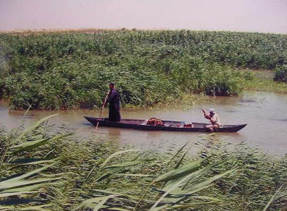
The Enki texts mention his boat possessing three means of propulsion: (1) a punting pole, (2) an oar, (3) a tow rope, perhaps for going upstream against a canal or river's flow. The below photo shows punting poles still in use by today's Marsh Arabs in Iraq. The below photo of a shallow reed-filled lagoon "probably" is what the area about Eridu looked like 2500 years ago, before the Euphrates moved away (today the Euphrates flows several miles to the north of Ur which in turn, is about 12 miles north of Eridu).
Dilmun in the "Sea of the Rising Sun":
A Proposal for the Sebkha adjacent to and east of Eridu
being the "Sea of the Rising Sun" and the location of Dilmun
14 February 2009 (revisions through 02 July 2009)
Please click here for Dilmun possibly being Umm Daleimin by Qurnah on the Shatt al Arab River in Iraq
----------------------------------------------------------------------------------------------------------------------------------------------------------------------
Special update of 03 March 2009:
I now realize that this article is in _error_ in identfying the "sea of the rising sun" with the Sebkha east of Eridu as appears on Professor Zarins' below map. Over the past several days (14 February through 04 April 2009)
I have been studying satellite maps of Eridu, Iraq and came to realize that the southernmost branch of Euphrates that empties into the Sebkah east of Eridu does not continue eastwards to Tell al Lahm (ancient Kisiga for some), it ends at the Sebkha. For it to get to Tell al Lahm it would have to "ascend" from the basin east of the Sebkah and that of course is a geographical impossibility. Please click here for additional satellite photos of Eridu and its Sebkhah. Ergo, Enki could not get to Tell al Lahm from Eridu via the Euphrates channel which empties into the Sebkah. However, via a canal going north from Eridu to Ur, as revealed by satellite images, Enki could glide downstream from Ur to Tell al Lahm.
Below, a map _incorrectly_ showing the Euphrates heading east from Eridu to the Sea Land or marshes near Tell al-Lahm (cf. p. 109. "Trade and Warfare 2000-1600 B.C." Micheal Roaf. Cultural Atlas of Mesopotamia and the Ancient Near East. New York & Oxford. Facts on File. 1990). This _incorrect_ rendering led me to mistakenly believe Enki at Eridu could via boat reach Tell al-Lahm which I thought might be Dilmun.
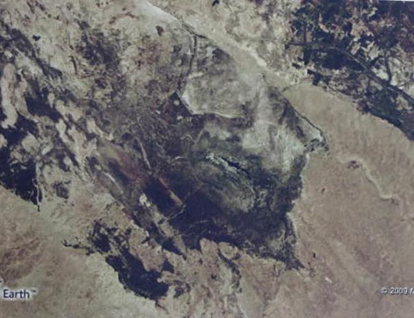
Below, a satellite photo of the basin Eridu lies in. The photo shows four modern levee walls (erected in the 1980's? by Saddam Hussein?) surrounding Eridu and a highway atop a levee going north towards Ur which lies on the alluvial plain above Eridu (top of photo). Eridu lies in a great basin 20 feet below the alluvial plain Ur is on. The Sebkha lake lies east of and lower than Eridu (viewer's right). The Euphrates cannot ascend some 20 feet or more out of this basin to go on eastwards to Tell al-Lahm, so this satellite image reveals Roaf's map is _wrong_ in showing the Euphrates passing to the south of Eridu and going on eastwards to Tell al-Lahm. The river channel seen at the viewer's right is of a wadi that flows _westward_ to empty into the basin.