Exodus Red Sea Crossing Map (Suez)
03 Jan. 2004
Please click here for my "latest map" showing the site of Israel's "crossing of the Red Sea" in the Exodus
as being at Ras el Ballah as of 21 November 2009
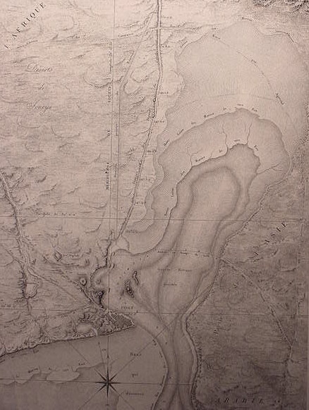
Map of Suez (1797-99) Napoleon Bonoparte's cartographic survey of Egypt) showing the "Persian Canal" begun by Pharaoh Necho in 610 BCE and completed by the Persian king Darius ca. 513 BCE, emptying into the bay north of Roman Clysma (modern Arabic Kolzum/Qolzoum) founded by the Roman Emperor Trajan (98-117 CE). Early Christian traditions of the 4th/5th century CE locate Israel's crossing of the Red Sea near Clysma as noted in the diary account of the Pilgrimess Egeria/Etheria, who visited the area. Another map by Smith shows various scholars suggestions for Israel's crossing of the Red Sea near Suez/Clysma. In the 1960's archaeological excavations revealed an ancient Egyptian fortress built by Ramesses III (ca. 1182-1151 BCE) beneath Trajan's fortress. Could this Ramesside fortress be the Bible's "Migdol" by Yam Suph (the Red Sea) ? Migdal in Semitic means a "tower-fortress." Another map (of 1856) outlines the shoals exposed at Low Tides to the north and south of modern Suez. In 1915 Tides as high as 10 feet were recorded for the port of Suez. A "Ship's channel" (a feature created by nature ?) hugs the western shore of the bay above the port of Suez and ancient Clysma/Kolzum/Qolzoum. Extensive shoals exposed at low tides flank both sides of the channel. Some scholars have suggested that Pi-ha-hiroth (Hebrew: pi-ha-chyiroth) may be a Semitic word (Akkadian/Babylonian), meaning mouth (pi) of the (ha) _canal or channel_ (Chyiroth, keeroth). Could the ship's channel passing by Clysma be the channel of Chyiroth/Keeroth ? The bay opposite Clysma is called in Arabic "Bahr el Kahrira." Could Kharira be Hebrew Chyiroth (-oth being a sufformative or word ending not preserved in Arabic) ? Does the Arabic Kharira preserve the Akkadian/Babylonian Kharru ("water-channel" or "irrigation-channel") ? The Mouth of the Channel would be the ship's channel in Kharira bay (the channel or Akkadian "Kharru," being transferred to the bay as Kharira (?) opposite Migdol (Clysma, the Ramesside fortress) ? George Lamsas' English translation of the Aramaic "Peshitta" (Holy Bible) says of Pi-ha-hiroth, "the inlet of Kheritha", suggesting it is a body of water which is part of the Red Sea. Is the "inlet" the ship's channel ? The map shows a "Camel Ford" beginning at the mouth of the Persian canal and crossing the bay of Bahr el Kharira. Was Israel envisioned as utilizing this ford at low tide ?
Alternately, If Pharaoh Necho began the building of the Red Sea canal at two sites, Wadi Tumilat in Egypt north of the two Bitter Lakes and simultaneously at Clysma ca. 610 BCE, perhaps the "mouth of Necho's Canal" above Clysma, became the "mouth of Kheritha" by ca. 562 BCE when I understand the Primary History (Genesis-2 Kings) to have been composed in the Exile. That is to say, if the "mouth or entry point" of Necho's canal above Clysma is Pi-ha-Hiroth, then the Exodus account, as we have it today, was written AFTER 610 BCE and no later than 562 BCE in the reign of the Babylonian King Evil-Merodach (cf. 2 Kings 25:27).
An excellent series of maps of Egypt, 1797-1798 by Napoleon's cartographers is available on the internet at the David Rumsey Historical Maps Archive.
To access these maps click on the below active url links.
When the map appears on your screen move your cursor across its surface, this will cause a zoom bar to appear.
Click on the + (plus sign) to activate the map's zooming bar's features; repeated clicking on the + magnifies the map, repeated clicking on the - (minus sign) decreases the magnifying effect.
By placing your cursor on the map while holding down your mouse key a hand will appear allowing you to move the Map about to various sectors, right, left, up and down.
Please Click Here for 1797-1797 a breathtaking overview of Egypt, the Sinai, and Palestine.
Please click here for "another" version (more details) of Egypt, including Suez harbor.