I understand that Genesis is _denying, refuting and challenging_ the Mesopotamian myths' explanation of Who, What, Why, Where, When and How man came to made, what his purpose on earth is, and why he does not possess immortality. I understand that the Hebrews accomplished these denialsor challenges by taking motifs and concepts from a variety of contradicting myths and giving them "new twists," changed the names of the characters, the locations, and sequences of events. It is my understanding that the Hebrews were deliberately CHANGING _or_ RECASTING the earlier myths and their motifs IN ORDER TO REFUTE AND DENY, AND CHALLENGE THEM, hence the "reason why" there are _no_ individuals called Adam, Eve, the Serpent, Yahweh, Noah, Shem, Japheth and Ham appearing in _any_ of the Mesopotamian pre-biblical myths. This "understanding" explains why there appear to be "echoes" or "parallels" or "similarities" between Genesis and the Mesopotamian concepts and motifs regarding man's creation. The Hebrews are NOT "copying" the Mesopotamian stories, they are RECASTING CERTAIN MOTIFS AND CONCEPTS WITHIN THEM in order TO REFUTE THEM.
Why did the Hebrews seek to deny, refute and challenge the Mesopotamian beliefs? Why did Christianity refute and deny Judaism? Why did Islam refute and deny Judaism and Christianity? Apparently each felt that its predecessor had wrong or erroneous beliefs regarding the relationship between God and Man and accordingly each sought to "correct" these "false" views via recastings or reworkings of the earlier stories in order to_deny, refute, and challenge_. For example, the New Testament while preserving verses from the Old Testament, gives these verses new meanings, rejecting the Jewish interpretations. Islam recast certain stories in the Old and New Testaments, Abraham offered his son Ishmael to God instead of Isaac, Jesus is not the God who made Adam and Eve in his role as the Logos or Word, Allah is the God of Abraham, not Yahweh or Christ.
For two millennia (2000 years) scholars have attempted to locate the Garden of Eden by identifying the Edenic rivers. It is obvious to me after some 30 years of personal research that this is a flawed and unproductive methodology. The below article will explore the "problems" in using modern maps of rivers and wadies (dry river beds) to pinpoint the location of the Garden of Eden.
I understand that the Garden of Eden is a myth, a later Hebrew reworking of motifs appearing in earlier Mesopotamian myths regarding how and why man came to be created by the gods. These myths reveal that man was created inorder to work in their city-gardens located in Lower Mesopotamia, then called Akkad and Sumer.
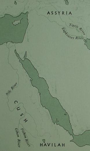
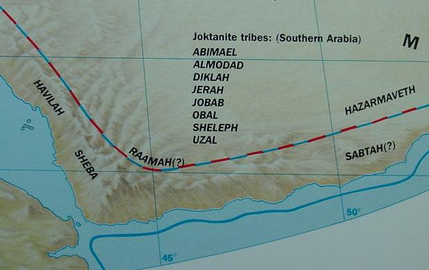
My research suggests that Genesis' notion that a river rises in Eden and becomes four streams is recalling the Euphrates subdividing into three or four branches in the Lower Mesopotamian floodplain. In support of this proposal I have provided several maps drawn up by scholars showing just such a situation. The perceptive reader will, of course, quickly realize there is _not_ agreement among scholars on how to show these subdivisions of the Euphrates. Some show three, others four streams. To some degree the subdivisions are based on attempts to align the streams with the remains of ancient cities who drew their water for irrigation purposes from them. On just about any subject there exists scholarly disagreements and controversy. The purpose of the below maps is to call to the reader's attention that "some" scholars understand the Euphrates subdivided into three or four streams in antiquity and this phenomenon _becomes for me_ the "background" for Genesis' portrayal of a river rising in Eden and becoming four streams. Some scholars have noted that the Hebrews in the book of Genesis appear to have borrowed and recast the Sumerian notion that ten kings reigned before the Shuruppak Flood of circa 2900 B.C. making them into Abraham's pre-flood ancestors (Genesis 5:1-28), denying that they are kings and changing their names. I suspect these scholars are correct. Perhaps the "four" streams crossing the Lower Mesopotamian floodplain called edin in Sumerian were _also_ "recast" with different names as well? That is to say, the Hebrews apparently preserved two of the four streams' names as the Euphrates (Purattu) and Hiddekel (Id-iqlat), but changed the names and locations of the other two streams, the Arakhtu/Arahtu and Abgal/Apkallatu (the Pishon associated with Havilah and Gihon associated with Cush)? With these caveats or warnings in mind let the reader proceed!
The first century A.D. Jewish historian Flavius Josephus understood that Eden's river subdivided into four great rivers which encompassed the world. Whether this is his speculation or he is passing on a tradition will never be known. If he is correct then it may possibly be that Genesis' narrator took the notion that a river in Eden subdivided into four streams (the Euphrates subdividing into four major channels in Lower Mesopotamia, the Sumerian edin/eden floodplain) and gave this phenomenon "_a new twist_," by having two of the streams flowing through the Mesopotamian edin/edin as flowing in other parts of the world? Perhaps Wadi Bishah near the Yemen becoming the Pishon (Khawlan in the Yemen becoming Havilah) and the Gihon becoming the Nile in Cush (Sudan)? In other words he was engaged in a little "tongue-in-cheek" over-embellishment or "stretching of the truth" of the real geographical facts: that a stream leaving God's garden in Eden is the source of water for _all_ the great streams of the known world, no matter how farway they are from Mesopotamia (the Gihon/Nile in Cush/Sudan and the Pishon/Bishah near the Yemen).
Many Christians are interested in locating the Garden _OF_ Eden. The Bible however, states that God planted a Garden _IN_ Eden:
Genesis 2:8 TANAKH (Philadelphia. The Jewish Publication Society. 1988. [5748 since the Creation])
"The LORD God planted a garden _in_ Eden, in the east, and placed there the man whom He had formed."
Some scholars understand Eden is Sumerian edin (Note: Sumerian edin is rendered as eden by some scholars), the great semi-arid plain of Lower Mesopotamia (where lay ancient Akkad and Sumer) crossed by the Tigris and Euphrates rivers and I am in agreement with this understanding.
Three CONTRADICTING Mesopotamian myths reveal man was created in three cities: Eridu, Nippur and Babylon by the gods Enki (Ea), Enlil (Ellil) and Marduk (biblical Merodach). Other myths, the so-called "Ewe and Wheat" and "Eridu Genesis Myth," state that primeval man aimlessly wanders a steppe (edin), abandoned and ignored by the gods, in a state of nakedness with wild animals for companions, eating grass and lapping water at waterholes before the goddess Nintur takes him from this place of desolation and has him build cities for the gods and care for their city gardens.
My personal research reveals that "many Mesopotamian locations or sites" are bound up in Yahweh-Elohim's "Garden _in_ Eden" account from differing myths involving different characters. That is to say, EVERY MESOPOTAMIAN CITY had its GOD'S GARDEN in which man worked, to provide food for the god. There is NOT _A_GARDEN_IN_EDIN, but _MANY_ GOD'S CITY GARDENS _IN_ EDIN. The Hebrews in "recasting" the Mesopotamian myths are _REFUTING_ this fact, replacing the many GOD'S CITY-GARDENS IN EDIN with ONE GOD'S GARDEN IN EDEN, portraying it as "unassociated" with a city; another Hebrew _refutation_ of the Mesopotamian belief that a God's garden is an aspect of the city the god dwells in. Genesis has Cain building the world's first city, Enoch, AFTER THE EXPULSION from the Garden in Eden. Genesis is refuting, challenging and denying the Mesopotamian understanding of how man came to be created and PLACED IN A GOD'S CITY GARDEN to care for it.
So, dear reader, in reality, it is quite impossible to "locate" the Garden _in_ Eden using Genesis' description of one river becoming four streams because this is a "recasting" of earlier Mesopotamian myths. No such river system exists or has ever existed except in the realm of fantasy and imagination.
Some Christian scholars claim Eden's garden can never be found because Noah's flood destroyed the original beds of the Edenic rivers, burying them under tons of Flood sediment. Some Roman Catholic scholars date Noah's Flood to ca. 2958 B.C. while some Protestants claim the Flood was ca. 2348 B.C. Both dates fall in the 3rd millennium BC. The problem? According to Geologists and Archaeologists there is no evidence of a worldwide flood covering the earth's mountaintops in the 3rd millennium B.C. Villages in the Middle East (Turkey, Syria, Iraq, Iran, Palestine and Egypt) are documented from the 12th through 1st millenniums B.C. and there is no universal Flood deposit in this period of time.There is also no geological evidence that the Tigris (biblical Hiddekel) and Euphrates rivers ever arose from one river. The biblical portrayal of Eden's river system is then, fantasy.
If scholars are "correct" that Sumerian edin was later transformed into Eden, and I assume they are, and if I am correct that the city gardens of edin (ancient Akkad and Sumer of Lower Mesopotamia) have been transformed into Genesis' Garden _in_ Eden, what then is recoverable for pinpointing the biblical "Paradise" on a modern map?
The "Golden Key" for unlocking the mystery of where the Garden in Eden lies is to _isolate the prototype_ for Mesopotamia's city gardens of the gods. In other words, WHAT CITY WAS THE _FIRST_ TO BE CREATED WITH ITS GOD'S CITY GARDEN according to the myths ? This "prototype" was identified over 100 years ago in the 19th century by professional scholars (Assyriologists). Even today, in the 21st century, one encounters in the scholarly literature the acknowledgement of the site which constitutes "the prototype" for the gods' city gardens in edin. This site has been excavated by trained archaeologists, its modern name is Tell Abu Shahrein, in the Sumerian myths it was called Eridug meaning "the good city," (Akkadian/Babylonian: Eridu). For further information on Eridu being the Mesopotamian EQUIVALENT of the Garden of Eden you will need to access an article which is divided into TWO parts. Please click here for PART ONE and click here for PART TWO (Note: after clicking on the article go to your browser menu at the top of your screen, click on the "FIND" Box, enter Eridu, and the FIND Box will scan the article highlighting this word, saving you the tedious task of reading the whole article. PLEASE READ _BOTH_ PARTS. A little warning: Eridu is but _one_ of several pre-biblical sites that came fused together into Genesis' garden of Eden)
Now, on to the Original Subject, the Four Rivers of Eden and the "Problems" in identifying them:
Apparently Sumerian edin, later superceded by Akkadian seru or seri, meaning "plain," also rendered "steppe" or "desert" by others, applies equally well to the "semi-arid desert-plains" of _both_ Upper AND Lower Mesopotamia. The Sumerians knew of two edins, a high steppe/plain called an edinand a low steppe/plain called ki edin. The term edin was applied to _uncultivated land_. The gods' city-gardens were _never_ called edin. The cities and their city-gardens were surrounded by uncultivated steppe/plain called the edin. Thus the gods' city-gardens were _in_ the edin, or surrounded by the edin. The Tigris and Euphrates rivers flow through the uncultivated edin, later, according to myths, the gods created Mesopotamia's cities and city-gardens in the formerly uncultivated edin and make man to care for their city-gardens.
For approximately 100 years (cf. Friedrich Delitzsch. Wo Lag das Paradies? [Where Lay the Paradise?] Leipzig, Germany. 1881) various scholars have suggested that Genesis' Eden is recalling the Sumerian word edin which is variously rendered by different scholars as "plain" or, on other occasions, "steppe," "desert," and "wilderness."
Therein lay the problem for me ! A "plain" can be a flood-plain _or_ a high plain ("steppe"). My earlier error was in assuming that edin or "plain" applied exclusively to the Lower Mesopotamian flood-plain. Steppe and Flood-plain are not synonymous in geographical nomenclature although both are types of a plain. Because I understand that the Euphrates is the "river of Eden" which becomes four rivers, it finally dawned on me that it is a single river ONLY in the high plain or "steppe" (Sumerian: an-edin) once it leaves this area near Sippar it breaks up into numerous channels across a much lower plain, the flood-plain (Sumerian: ki edin). Because I understand that edin is the Mesopotamian plain from Haran to Eridu, the river of Eden mentioned in Genesis is the Euphrates from the Habur river to Ramadi. Near Sippar (south of Ramadi) it becomes several channels, thus Genesis' "single" river in Eden as well as its four streams, both lie in edin the plain, the high plain or steppe as well as the low plain or flood plain of Lower Mesopotamia!
Maisels on edin being the uncultivated "steppe" surrounding Mesopotamian cities:
"The wool and meat requirements were met by continuous movements from the periphery of Mesopotamia to the temple centres, funneled largely through Dreham (Calvot 1969:103-13) to supplement the state herds kept on both the alluvial fallow and upon the surrounding non-cultivable (edin) steppelands (Adams 1981:148). Steppe, stubble, and riparian verdure were, however, systematically linked in the ecology of pastoral nomadism, tribally organized." (p. 186. Charles Keith Maisels. The Emergence of Civilzation, From hunting and gathering to agriculture, cities, and the state in the Near East. London & New York. Routledge. 1990, 1993. ISBN 0-415-096596 paperback)
To the degree that Sumerian edin means "uncultivated steppe" please click here for a map showing the Tigris and Euphrates rivers flowing through steppelands as demarcated by Maisels. In other words, Maisel's map of "the steppe" reveals the location of "edin-the-uncultivated-steppe," and to the degree some scholars have suggested the biblical Eden is derived from Sumerian Edin you will "see" what Eden looks like, its huge! Note: The Mesopotamians never called their city-gardens Edin. Their cities and city-gardens LIE IN or WERE SURROUNDED BY UNCULTIVATED STEPPE (THE EDIN).
Pinches:
"Like Sippar too, Babylon was situated in what was called the plain, the edina, of which Babylonia mainly consisted, and which is apparently the original of the Garden of Eden." (p. 43. Theophilus G. Pinches. The Old Testament In the Light of the Historical Records and Legends of Assyria and Babylonia. London. Society For Promoting Christian Knowledge. 1908)
Pinches -if I am reading him right- notes the mention of Sumerian edin as a "plain" of verdue (my emphasis):
"Though one cannot be dogmatic in the presence of the imperfect records that we possess, it is worthy of note that _Eden DOES NOT OCCUR_ as the name of the earthly paradise in any of the texts referring to the Creation that have come down to us; and though it is to be found in the bilingual story of the Creation, it there occurs simply as the equivalent of the Semitic word _serim_ in the phrase "he (Merodach) made the verdue of the _plain_." (p. 72. "From the Creation to the Flood." Theophilus G. Pinches. The Old Testament In the Light of the Historical Records and Legends of Assyria and Babylonia. London. Society For Promoting Christian Knowledge. 1908)
Some explanation is needed here regarding Akkadian seru, seri or serim and its replacement of Sumerian edin:
Professor Blenkinsopp of Notre Dame University (1992) on motifs and concepts drawn from the Atrahasis Flood myth and the Epic of Gilgamesh by Genesis' author:
"...just as Genesis 1-11 as a whole corresponds to the structure of the Atrahasis myth, so the garden of Eden story has incorporated many of the themes of the great Gilgamesh poem." (pp. 65-6. "Human Origins, Genesis 1:1-11:26." Joseph Blenkinsopp. The Pentateuch, An Introduction to the First Five Books of the Bible. New York. Doubleday. 1992. ISBN 0-385-41207-X)
I understand that Enkidu and Shamhat have been recast by the Hebrews into Adam and Eve in agreement with Professors Graves and Patai (cf. pp. 78-79. "The Fall of Man." Robert Graves & Raphael Patai. Hebrew Myths: The Book of Genesis. New York. Greenwich House. 1963, 1964, reprint of 1983) and the watering hole they encountered each other at has been transformed into Genesis' Garden _in_ Eden.
What "baffled" me for the longest time was, how did the encounter of Enkidu (Adam) and Shamhat (Eve) at a watering hole in the Akkadian seru ("steppe") come to be morphed later by the Hebrews into the Hebrew word `eden?
The Sumerian word for uncultivated steppeland is edin. The Epic of Gilgamesh although written in Akkadian which renders "steppe" as seru or seri, states unequivocally that Shamhat saw Enkidu at the watering hole as a wild man of "edin" (the steppe). How is it that the watering hole is described as being in _the edin_ instead of being in _the seru_?
Akkadian scribes were trained in both Sumerian and Akkadian, they frequently used Sumerian LOGOGRAMS (cuneiform signs) as "substitutes" for Akkadian words. Hence Enkidu "the wild man of the steppe" was written using the Sumerian logogram (EDIN)! The scribe knew upon seeing this logogram that it was synonymous with the Akkadian word seru or seri, meaning steppe.
Professor Spieser on Enkidu's arrival at the watering hole in the steppe (steppe in Sumerian being edin, Akkadian seru), where wait Shamhat the harlot-priestess of Uruk and the Hunter (Note: the below bold print is transcribed by Heidel, which follows, into Akkadian):
"The creeping creatures came, their heart DELIGHTING in water.
But as for him, Enkidu, born in the hills-
With the gazelles he feeds on grass,
With the wild beasts he drinks at the watering-place,
With the creeping creatures his heart DELIGHTS in water-
The lass beheld him, the savage-man,
The barbarous fellow from the depths of the steppe:
"There he is, O lass, Free thy breasts,
Bare thy bosom that he may possess thy ripeness!
Be not bashful! Welcome his ardor!
As soon as he sees thee, he will draw near to thee.
Lay aside thy cloth that he may rest upon thee.
Treat him, the savage, to a woman's task! Reject him will his wild beasts that grew up on his steppe,
As his love is drawn unto thee."
The lass freed her breasts, bared her bosom,
And he possessed her ripeness.
She was not bashful as she welcomed his ardor..."
(p. 44. E. A. Speiser. "The Epic of Gilgamesh." James B. Pritchard. Editor. The Ancient Near East, An Anthology of Texts and Pictures. Princeton, New Jersey. Princeton University Press. 1958. paperback)
Heidel reproduces the above words (which I have rendered above in bold print) from the Epic of Gilgamesh ("he" is in reference to Enkidu):
"...while on Tablet I. 4:7, he is called
itlu (GURUS) sag-ga-sa-a sa-qa-bal-ti seri (EDIN):
"The savage man from the midst of the seru."
(cf. p. 233. Alexander Heidel. "A Special Usage of the Akkadian Term Sadu." The Journal of Near Eastern Studies. Vol. 8. No. 3. July 1949)
My thanks to Robert M. Whiting, PhD. of Helsinki, Finland, a professional Assyriologist (Managing Editor of the world-renown Neo-Assyrian Text Corpus Project, The Assyrian State Archives Series) for explaining to me that Heidel's 1949 transcription reveals that the scribe actually wrote the word "steppe" using the Sumerian LOGOGRAM (EDIN), and that modern scholars "read" (EDIN) as a substitution for seru. Heidel's transcription also reveals that the Akkadian word itlu was actually written as (GURUS) another Sumerian LOGOGRAM. Whiting explained that the use of Sumerian logograms in lieu of Akkadian words is quite common in Akkadian compositions.
Whiting's explanation solved the the long-standing mystery for me of how _seru_ the "steppe" came to become Hebrew `eden, I realized that the Hebrews had apparently _morphed_ the Sumerian logogram (EDIN) into Eden! Hebrew `eden means "DELIGHT" or a "placed well-watered," and we are told when Enkidu appeared at the watering hole in EDIN, his and the wild animals' heart's DELIGHT was its "WATER." So, I understand that the Hebrews took this notion of a naked man's DELIGHT over WATER and _morphed_ EDIN's watering hole into Hebrew `eden, a place of DELIGHT (The Mystery solved at long last, after some 3000 years!).
Enkidu's exploits first appear in several Sumerian short stories which were later brought together to create the Akkadian Epic of Gilgamesh and the plain/steppe he wanderd naked with animal companions (like Adam) is edin in Sumerian. The Akkadian "rewrite" apparently preserved the original Sumerian logogram (EDIN). So a naked Shamhat had sex with a naked man of (EDIN), and this act of copulation lasting 6 days and 7 nights caused his wild animal companions the gazelles to flee from him when he attempted to rejoin them. Shamhat convinced him to leave (EDIN) with her and go to Uruk to meet Gilgamesh. He agrees and she covers his nakedness with part of her clothing. The naked man of (EDIN) who has been forsaken by his animal companions casts his lot with womankind for companionship (just as naked Adam's animal companions were supplanted by a naked Eve) and together they leave (EDIN"S) watering hole clothed and naked no more. Down through the millennia the "undoing" of a naked man of (EDIN) and his casting his lot with a naked woman instead of the animals of edin/seru was preserved in the Sumerian logogram (EDIN). Clay tablets written in Akkadian from Jerusalem were found at Tell el Amarna in Egypt, the capital of Pharaoh Akhenaton (reigned: 1350-1334 B.C.). These tablets reveal the city had scribes trained in Sumerian and Akkadian and I suspect they passed on to their Jewish sons and daughters the story of the wild naked man of (EDIN) who was forsaken by edin's beasts over a naked woman, and these Jews in Iron Age II (1100-587 B.C.) rewrote this account as Adam and Eve in Eden. When Enkidu arrived at the watering hole we are told his and the beasts' hearts' _DELIGHT_ was its water. Shamhat, however saw the watering hole as a place of DESOLATION, bereft of shepherds, urging Enkidu to leave with her this edin. I "suspect" the Jews _morphed_ Enkidu's and the beasts' heart's DELIGHT with water at the watering hole in (EDIN) with the Hebrew word 'eden meaning DELIGHT or "a place well-watered" (so, some scholars). The Hebrews (Jews) are denying, refuting, and challenging the Mesopotamian understanding that the gods' gardens are city-gardens and their hearts' delight is to live in cities. The Hebrews have God's garden as being in the midst of the wilderness of 'eden (edin) where can be found in Mesopotamian myths naked man with wild animals for companions DELIGHTING in the water of the watering holes of edin. Edin's watering hole is _not_ presented in the Epic of Gilgamesh as a God's city-garden or a lush garden, it is a place of desolation in city dweller's eyes, only naked primeval man and his wild animals have their "heart's DELIGHT" here in its water.
Please click here for a map showing what I believe to be the location of watering hole where Enkidu (Adam) was "undone" by Shamhat (Eve), which became Genesis' garden in `eden.
As regards the Iron Age II (1100-587 B.C.) Jews being _descendants_ of Jerusalem's Jebusites who had scribes trained in writing and reading Sumerian and Akkadian here's the Bible's explanation:
Judges 3: 5-6 RSV
"So the people of Israel dwelt among the Canaanites, the Hittites, the Amorites, the Perizzites, the Hivites, AND _THE JEBUSITES_; and they took their daughters to themselves for wives, and their own daughters they gave to their sons; and they served their gods."
Note: Some Conservative Protestant Scholars understand the Exodus was circa 1446 B.C. and Conquest of Canaan circa 1406 B.C. For these scholars "the days of the Judges" extend from 1406 B.C. to Saul's reign circa 1020 B.C. The Jebusites of Jerusalem, circa 1350-1334 B.C., _in_ "the days of the Judges" possessed scribes trained in writing Akkadian and Sumerian as witness the letters from Jerusalem to Pharaoh Akhenaten advising him only Jerusalem remains loyal to Pharaoh, the rest of the land has gone over to Pharaoh's enemies described as "slaves who have become Habiru." I "suspect" the Jewish descendants of the Jebusites transformed the Mesopotamian accounts handed down to them from their Jebusite ancestors, transforming them into Genesis' Garden of Eden account.
Alternately: Perhaps Terah, Nahor and Abraham of Ur of the Chaldees transformed edin into `eden?
There is some confusion on how to interpret Genesis' statement regarding the "river of Eden" and its four streams, do the streams divide after leaving the garden or does the division of one river into four streams occur within the garden? What is mean by "THERE"? The land of Eden? or the garden of Eden?
Genesis 2:10, RSV
"A river flowed out of Eden to water the garden, and THERE it divided and became four rivers."
The Jewish scholar Yahuda (1934) thought the splitting of the four rivers occured _after_ leaving the garden of Eden:
"It must first be emphasized that in Genesis 2:10 there is no mention of four rivers flowing through paradise. Quite on the contrary, it is expressly stated that "a river went out of Eden to water the garden," which can only mean one river. The four rivers mentioned immediately afterwards actually have nothing to do with paradise itself. The whole passage (Genesis 2:10-14) does not refer to paradise, but to the relation of the four rivers to that one river of paradise. All that this passage meant to convey was that the one river of paradise gave origin to the four greatest world streams, thus representing paradise as the source of prosperity and fertility for the whole earth...As already stated, the text of the Paradise story does not say a single word which suggests that the four rivers were within the paradise "to water the garden." The Hebrew text of Genesis 2:10 does not mean that the division of the one river into four was effected within the area of paradise. What it means to convey is that those rivers came forth from that one river after it had left the garden." (pp. 164-165; 168. "The Story of Paradise." Abraham S. Yahuda. The Accuracy of the Bible, the stories of Joseph, the Exodus and Genesis Confirmed and Illustrated by the Egyptian Monuments and Language. London. William Heinemann Ltd. 1934)
The Jewish scholar Cassuto seems to agree with Yahuda (1944):
"...we are told that a river flowed out of Eden to water the garden, and thereafter it divided into four big rivers..." (p. 77. Umberto Cassuto. A Commentary on the Book of Genesis. Vol. 1. [From Adam to Noah]. Jerusalem. The Hebrew University. 1944-1968 in Hebrew; 1961-1989 in English. ISBN 965-223-480-X)
If the Hebrew Eden is recalling the Sumerian/Akkadian edin-the-steppe, the problem becomes finding a river in "edin-the-steppe" of Mesopotamia that becomes four rivers!
I suspect that what is being recalled here is the Euphrates being the source of numerous streams which crisscross the floodplain of Lower Mesopotamia. That is to say edin-the-steppe (a steppe is geographically described as a high plain, usually grassy with no trees, except where a river in the steppe might provide enough water for their growth) is NOT exclusively Lower Mesopotamia's great floodplain from Baghdad to the Persian Gulf -as I had earlier and mistakenly thought- but instead, _also_ Northern Mesopotamia's high steppe from the vicinity of ancient Haran to Sippar (modern Abu Habbah west of Baghdad). Thus I am _now_ proposing that "the river of Eden" is the Euphrates between Haran and Sippar and that Eden is both the "High Plain" and Low Plain . That is to say, the "Garden of Eden" appears to have been located in Mesopotamia! We are told Eden was located "IN THE EAST" and we are told that Haran, which came to be identified with Abraham's adoptive home was "IN THE EAST". That is to say, Haran is in edin-the-plain of Northern Mesopotamia:
Genesis 29:1, 4 RSV
"Then Jacob went on his journey, and he came to the land of the people OF THE EAST...Jacob said to them, "My brothers, where do you come from?" They said, "We are from Haran."
Ancient Mesopotamian texts spoke of Sippar as Sipar Edina, translated by Pinches (1908) as "Sippar of Eden." Geologically speaking _the High Steppe of northern Mesopotamia _begins near Sippar_, and it is in this location that the Euphrates is transformed from a single stream to several watercourses as it meanders over the great floodplain of Lower Mesopotamia and eventually empties into the Persian Gulf. So, perhaps Sipar Edina means "Sipar of the Steppe"?
Pinches (1908) on edin (his edina) possibly being Eden of the Bible:
"It had long been known that one of the Akkadian names for "plain" was edina, and that that word had been borrowed by the Babylonians under the form edinnu, but it was Professor Delitzsch, the well-known Assyriologist, who first pointed out to a disbelieving world that this must be the Eden of Genesis. The present writer [Pinches] thought this identification worthless until he had the privilege of examining the tablets acquired by Dr. Hayes Ward in Babylonia on the occasion of his conducting the Wolfe expedition. Among the fragments of tablets that he then brought back was a list of cities in the Akkadian language (the Semitic Babylonian column was unfortunately broken away) which gave the following:
TranscriptionTranslation
Sipar, D.S. Sippara.
Sipar Edina D.S. Sippara of Eden.
Sipar uldua D.S. Sippara the everlasting.
Sipar Shamash D.S. Sippara of the Sun-god.
Here at last was the word Eden used as a geographical name, showing that the explanation of Delitzsch was not only plausible, but also, in all probability true in substance and in fact." (p. 70. "From the Creation to the Flood." Theophilus G. Pinches. The Old Testament In the Light of the Historical Records and Legends of Assyria and Babylonia. London. Society For Promoting Christian Knowledge. 1908)
Perhaps Genesis' notion that the Euphrates and Tigris were once a part of an edenic stream is recalling a 4th millennium B.C. situation preserved in very ancient oral traditions "from before" Abraham's 3rd millennium B.C. world?
Cf. the below statements by Michael Roaf (an Associate Professor at the University of California, Berkeley) and Susan Pollock (an Associate Professor at the State University of New York, Binghamton) on the Tigris and Euphrates _separating from each other_ in this time period:
Roaf (emphasis mine in capitals):
"In the Early and Middle Uruk periods there was a vast increase in the number and size of sites. The northern part of the region near Nippur, where meanders of an old river course can still be seen, was particularly well populated. This ancient course was about the same size as the modern Euphrates. It appears that in the Early and Middle Uruk times THE TIGRIS AND EUPHRATES JOINED FARTHER UPSTREAM and then flowed in a number of channels through the alluvial plain." (p. 59. "The Urban Explosion, 4000-3000 B.C." Michael Roaf. Cultural Atlas of Mesopotamia and the Ancient Near East. Facts on File. 1990. ISBN 0-8160-2218-6)
Pollock on the _union_ of the Tigris and Euphrates prior to the 4th millennium B.C. and their consequent separation when the Euphrates moved westwards (emphasis mine in capitals):
"Around the middle of the fourth millennium, the Euphrates abandoned one or more of its major channels in the northern alluvium, shifting its bed further to the west. This shift RESULTED IN THE SEPARATION OF THE TIGRIS AND EUPHRATES. It may have contributed to the frequent movement of settlements in the Nippur-Adab region during that time as people relocated to follow water availability." (pp. 71-72. "Settlement Patterns." Susan Pollock. Ancient Mesopotamia, The Eden that Never Was. New York. Cambridge University Press. 1999, 5th printing 2004. ISBN 0-521-57568-0 paperback)
"The frequent shifting of settlements, especially smaller ones, is a striking feature of the settled landscape of southern Mesopotamia...Cessation of flow in river or irrigation channels must also have played an important role in settlementshifts. Channel movement need not have been dramatic AS THE SPLITTING OF THE TIGRIS AND THE EUPHRATES in the first half of the fourth millennium; even relatively small shifts could have left communities without adequate water supplies." (p. 76. "Settlement Patterns." Susan Pollock. Ancient Mesopotamia, The Eden that Never Was. New York. Cambridge University Press. 1999, 5th printing 2004. ISBN 0-521-57568-0 paperback)
Leick on Sippar's being founded in the fourth millennium at a time when the Euphrates and Tigris were joined in the Uruk period, circa 3500 to 3200 B.C. (Emphasis mine):
"Sippar lies some 20 kilometres south of Baghdad, where the courses of the Euphrates and Tigris come closest together. Like so many other Mesopotamian cities, its fate depended on the often erratic behaviour of these rivers, and the close proximity and interaction of the two flows resulted in particular hydraulic effects. ACCORDING TO GEO-ARCHAEOLOGICAL SURVEYS _THE RIVERS WERE ACTUALLY CONNECTED_ WHEN THE SITE WAS FIRST INHABITED DURING THE URUK PERIOD. Deposits of silt left by the Euphrates formed levees to make a habitable elevation above the flood plains. The city itself was situated along the Euphrates. The high content of sediment carried by this river had the gradual effect of burying the older Tigris channels, pushing that river further to the east. At the same time, the rising of the river bed caused a shift of the Euphrates further westwards, which resulted in a steady separation of the twin rivers, leaving an area of land which could be cultivated...Sippar had access to both major streams and their side-arms, though, during the historical periods, the Euphrates was far more important than the Tigris as a navigable waterway." (p. 167. "Sippar, A Tale of Two Cities." Gwendolyn Leick. Mesopotamia, The Invention of the City. London. Penguin Books. 2001)
Leick cites the work of de Meyer, Gasche and Paepe (1971), pp. 25-26 on the joining of the Euphrates and Tigris in antiquity (p. 299. Leick); cf. L. de Meyer, H. Gashe and R. Paepe (1971), Tell ed-Der I. Rapport preliminaire sur la premiere compagne, fevrier 1970, Leuven. (p. 323. Leick)
Crawford on the possibility that the Tigris and Euphrates united in the 6th-5th millennium B.C. from which arose several streams, stating that Adab, Umma and Larsa were fed by the Tigris. I note that after leaving Larsa the Tigris MERGES with the Euphrates just west of Ur, and eventually a COMBINED AND MERGED TIGRIS/EUPHRATES empties into the sea that Ur and Eridu lay next to in 3rd millennium B.C. texts. The fabled island of Dilmun, believed to ba a prototype of the Garden of Eden by some scholars was said to "lie at the mouth of the rivers," and the mouth of the Combined and Merged Tigris and Euphrates is near Ur/Eridu, suggesting for me Dilmun is Tall al-Lahm 20 miles east of Ur/Eridu.
Crawford (Emphasis mine):
"Here, in the southern plain, we can provide better evidence for the changes which have taken place in the environment over the six or seven thousand years since the plain was first permanently settled. The most important of these changes is in the course of the rivers. A combination of aerial and ground surveys indicates that the Tigris and Euphrates may at one time have formed ONE STREAM in the vicinity of modern Baghdad. A number of streams then ran out into the alluvium. Adams (1981) suggests that this may have been the position at the time of the earliest settlement on the plain in the fifth or early sixth millennium. Gradually some of the smaller streams dried up, leaving a forerunner of the modern Euphrates running approximately in the middle of the alluvium, while the Tigris lay slightly to the east of it, flowing through Adab, Umma and Larsa. The latter river was not edged eastwards into its modern bed until after the Kassite period in the later second millennium (Steinkeller 2001). The westward movement of the Euphrates can be traced on the ground, and by the progressive abandonment of ancient sites, such as the old religious capital of Nippur, which were founded on the old course of the river. The two rivers come together again at the southern end of the alluvium to form the Shatt-el-Arab, which winds its way through the great reed beds described so vividly by Wilfred Thesiger (1964), among others, out into the Arabian Gulf." (p. 9. Harriet Crawford. Sumer and the Sumerians. Cambridge, England. The Cambridge University Press. 1991, 2004)
The late Professor Andrew Sherratt (Oxford and Sheffield Universities, United Kingdom) on the Tigris and Euphrates "uniting" with each other from the fourth to the start of second millenniums B.C.:
"In the fourth millennium B.C., the UNIFIED TIGRIS AND EUPHRATES RIVERS ran down the spine of the elongated fan; by the beginning of the second millennium the two rivers appear to have split into separate channels, displaced outward from the central axis; in later historical times the two main watercourses have been further displaced, now running along the margins of the basin before being forced back together by the Batin and Karun-Karkeh fans, to flow through Basra to the present head of the Gulf. In consequence the central axis, once the best-watered and most fertile region, is now relatively arid and saline; in almost complete contrast to the landscapes which surrounded the earliest cities." (Map commentary #17. "Evolution of the Tigris-Euphrates Fan System." Andrew Sherratt. 'Environmental Change: The Evolution of Mesopotamia', ArchAtlas, October 2006, 2nd Edition, http://www.archatlas.org/EnvironmentalChange/EnvironmentalChange.php, Accessed: 15 April 2007)
Below, Professor Sherratt's map showing the Tigris _merging_ with the Euphrates in the vicinity of ancient Sippar south of modern Baghdad.
The Bible's chronology suggests for some scholars that Abraham was born at or near Ur of the Chaldees, modern Tell al Muqayyar (according to some), circa 2100 B.C. That's within the 3rd millennium B.C. portrayed on the above map showing this area circa 3000-2400 B.C. Could Abraham of Ur be "the source" of the Hebrew notion that Eden's river divided into four other rivers or "heads"? He would have received this tradition from the citizens of Ur. This city does possess cuneiform records that could have kept alive the memory of a river dividing into four parts as it crossed the floodplain of Lower Mesoptamia.
Of interest here is an observation made by Martin who made a survey in 1973 at nearby Shuruppak (Arabic: Tell Fara) that in this millennium the Euphrates subdivided into four heads or streams, which recalls for me Genesis' notion the river of Eden divides into four heads (Hebrew: rasim):
Leick on Martin's observations about Shuruppak (emphasis mine):
"As Martin has observed, 'undoubtedly its [Shuruppak's] position on the Euphrates near THE HEADS OF FOUR WATERCOURSES flowing down the eastern Euphrates was at least responsible for this boom. Similarly she sees the decline of Shuruppak in the later peiods as a result of a weakened economy caused by the shifting of the Euphrates to its western branch." (p. 64. "Shuruppak." Gwendolyn Leick. Mesopotamia, The Invention of the City. London. Penquin Books. 2001. Paperback. Citing H. P. Martin. Fara: A Reconstruction of the Ancient Mesopotamian City of Shuruppak. Birmingham, England. 1988)
This event may have occured about 3000 B.C. :
"The city of Kish...had a particularly favoured position on the upper Euphrates after the major shifting of the river to its western branch at around 3000." (p. 81. Gwendolyn Leick. Mesopotamia, The Invention of the City. London. Penquin Books. 2001. Paperback)
Leick on the Shuruppak flood:
"That flood stories should be popular in the alluvial plains of Mesopotamia is not surprising. Rivers are liable to sudden shifts of course since there are no natural obstacles to stop them meandering. Archaeologists have found deposits of silt in several places, including one at Shuruppak, where Schmidt identified an 'inundation level' composed solely of alluvial silt between the Jemdat-Nasr and the Early Dynastic I level. The city was rebuilt a little bit further away and life reasserted itself. It appears that floods were local phenomena rather than the whole-scale destructions of the myths since none of the archaeologically documented layers of silt are from the same period. Nevertheless, for the affected region the effects of a sudden flooding would have been devastating enough to leave a lasting impression. The flood level also speaks for the authenticity of the association with Shuruppak as the last antediluvian kingdom, since it is likely that the transition from the Jemdet-Nasr to the Early Dynastic period also marked the relative leading importance of Shuruppak at this time in Mesopotamian history.
The wise man of Shuruppak, his knowledge of 'words' and his devotion to his god, epitomize the specific values much admired in Mesopotamian culture. The message of the flood heroes and the eponymous sage Shuruppak is that the most lasting achievements of urban civilization are not buildings and walls, since they can be swept away and turned into ruins and fields; and not power, since the gods control all destiny, but knowledge and humility." (pp. 83-84. "Shuruppak." Gwendolyn Leick. Mesopotamia, The Invention of the City. London. Penguin Books. 2001. Paperback)
Professor Pritchard (emphasis mine) on Shuruppak being where the "Mesopotamian Noah" (Here called Utnapishtim, but in other texts, Atrahasis and Ziusudra) is warned by his god of a universal flood to be sent by the gods to destroy all of mankind, and build a boat of reeds from his reed-hut to save self, family and animals:
"Utnapishtim said to him, to Gilgamesh:
"I will reveal to thee, Gilgamesh, a hidden matter
And a secret of the gods will I tell thee:
SHURUPPAK -a city which thou knowest,
[(And) which is on Euphrate's [banks] is situate-
That city was ancient, (as were) the gods within it,
When their heart led the great gods to produce the flood...
MAN OF SHURUPPAK, son of Ubar-Tutu,
Tear down (this) house, build a ship !
Give up possessions, seek thou life.
Forswear worldy goods and keep the soul alive !
Aboard the ship take thou the seed of all living things."
(p. 66. The Epic of Gilgamesh." James B. Pritchard. Editor. The Ancient Near East, An Anthology of Texts and Pictures. Princeton University Press. 1958. paperback)
How did a "local" flood at Shuruppak become in later ages a worldwide flood? Perhaps the "mechanism" is the Sumerian word KUR which can mean "land," "country," "underworld," and "mountain." Perhaps at some later point in time someone either "playfully, deliberately, or mistakenly" understood a flooded KUR (land) to be a flooded KUR (mountain) ? Via this misunderstanding, it would be logically concluded that if a KUR (mountain) is being engulfed by a flood, ergo the whole world and its mountains (KUR) are also being flooded? The Hebrew word for mountain is HAR, pronounced CHAR/KHAR. THe country called by the Assyrians Urartu is rendered Ararat by the Hebrews, could the u/a interchange account for kur becoming Hebrew har (pronounced khar/char)?
Please click here for a photo of a 3rd millennium B.C. bas-relief found at Shuruppak perhaps showing "Noah's Ark."
All proposals on Eden's one river becoming four are in the end only "speculations." I recall some scholars suggesting Wadi Batin from Saudi Arabia being the Pishon connecting with the Euphrates near the Shatt al Arab and then the Euphrates itself along with the Tigris empty into the Shatt al Arab, then the Karkun (Gihon according to some) from Iran's Zagros mountains also connects with the Shat al Arab. However these "four" rivers are not coming _out of one river_, they are flowing _into it_ just the "opposite" of Genesis' scenario.
As regards Noah's Flood destroying the Edenic river courses- this is a pretty common understanding since the late 17th century A.D. among some scholars.
Delumeau:
"The conviction that the earthly paradise had been destroyed was almost universal among Protestant commentators on Genesis...Catholic commentators in increasing numbers agreed with their Protestant adversaries on this subject. At the end of the seventeenth century the most widely accepted view was that the earthly paradise had indeed existed as a historical reality, but that it had been erased from the surface of the planet." (p. 154. Jean Delumeau. A History of Paradise, The Garden of Eden in Myth and Tradition. New York. Continuum Publishing Company. 1995)
The problem? A Mesopotamian text of the 2d millennium B.C. has the flood at a city called Shuruppak in Sumer, its king, called Ziusudra (also called Atrahasis and Utnapishtim) is warned by his god Enki to build a boat and save himself, family and animals. He does.
Shuruppak has been identified as present day Tell Fara. When excavated a "flood layer" of two feet of clay was found and dated to circa 2900 B.C. It was the _only_ flood deposit found at the city. It appears at the end of Jemdat-Nasr phase and above it lies a new era called Early Dynastic I. The residents of Shuruppak rebuilt their city after the flood but "nearby" rather than directly over the flooded site. Microscopic analysis of the alluvial sediment overlying "Jemdat-Nasr" Shuruppak was determined to be caused by a flooding Euphrates, not a world wide flood. While many Protestant King James Version Bibles calculate Noah's Flood as ca. 2345 B.C., the Roman Catholic Bible, descended from the Septuaginta and Latin Vulgate, calculates the Flood as occurring circa 2958 B.C., a scant 58 years "off" from the circa 2900 B.C. Shuruppak alluvial flood deposit ! The Jewish Seder Olam Rabbah, dates the Flood to circa 2522 B.C. Which _CONTRADICTING_ BIBLE DATE FOR THE FLOOD IS CORRECT? It would appear that the Roman Catholic Flood date of 2958 B.C. is "closest" to Shuruppak's 2900 B.C. Flood. Please click here for the "many" CONFLICTING DATES for the Flood found in various Bibles, Protestant, Catholic, Jewish, Samaritan, Aramaic, and Greek Orthodox.
Many scholars who study the Mesopotamian account are struck by the "parallels" between the Shuruppak flood and the Genesis' flood. Both heroes are warned by a god to save themselves by building a boat. The flood occurs at the "end" of a _600_ year cycle for Ziusudra; Noah is _600_ years old (Ge 7:11) when the flood occurs. Both heroes are given seven days notice before the flood's arrival; After the flood both send out birds to find evidence of land appearing above receding waters; both offer a burnt offerings sacrifice after the flood. The god (Enlil) who sent the flood gives the survivors of the flood (on the boat) a blessing; Yahweh gives a blessing to Noah after the flood too. A god (Enlil) swears he will never send another flood to destroy all of mankind; so too Yahweh.
The biblical chronology for the Flood suggests for some Conservative scholars a date circa 2348 B.C., in the 3rd millennium BC. Archaeologists dated Shuruppak's flood layer to the 3rd millennium BC, circa 2900/2800 B.C. Other flood layers have been found at other cities in Sumer, but they are of different periods of time. Not finding any evidence of a flood destroying _all_ the cities of 3rd millennium B.C. Sumer, some scholars, understandably, have reservations about the biblical account of a 3rd millennium B.C. Flood.
Some scholars understand the biblical flood is recalling the Shuruppak flood event because of above noted similiarities in the two accounts, Mesopotamian and Biblical. Because they also understand the Shuruppak flood did not encompass the world, they therefore seek the river of Eden and its four "heads" (Hebrew: rasim) somewhere in the confines of a 5th through 3rd millennium B.C. Mesopotamia (The world being created by Yahweh ca. 4004 B.C. according to the biblical chronology worked out by a 17th century A.D. Christian scholar, Archbishop James Ussher of Armagh, Ireland).
To date, archaeologists have failed to find evidence of world wide flood in the 5th-3rd millenniums B.C. in Mesopotamia, Syria or Canaan. They date some settlements in Sumer to the Ubaid period of circa 4900 B.C., specifically the ancient city of Eridu (modern Abu Shahrein near Ur of the Chaldees), which in Mesopotamian myths was the very first city built by the god Enki. This myth has the world covered in water, then a freshwater stream eurpts from the depths of the ocean, land forms about it and Enki builds the first city Eridu. Of course in the Bible the first city is built by Cain and called Enoch after his son (Ge 4:17). So, it is clear that Genesis' author understands at least _one city_ built by Cain sometime in the course of the 4th millennium was engulfed by Noah's 3rd millennium B.C. flood, but the archaeological evidence does not support this notion.
Bright (1961) on a world encompassing flood's absence in the 3rd millennium B.C.:
"Has Archaeology Found Traces of the Flood?
...For excavations in Palestine and Syria the answer is an unqualified "No." In these two countries some of the oldest towns in the world have been excavated. We know now that Jericho was founded near the beginning of the Late Stone Age. While we cannot be certain that the town was first settled in such an early period, we can be sure that the town was first settled between about 5000 and 4500 B.C. This city and others in Palestine established after it show no evidence whatever of a flood...
1. The evidence from Ur...At Ur Wooley found a continuous occupation from the Early Dynastic back to the Obeid Period. In the middle of the Obeid level he found a stratum of river mud or deposit some ten feet thick -conclusive proof that a deluge had interrupted the occupation of the place, at least temporarily, during the fourth millennium. Wooley is confident that he has here the evidence of Noah's flood (see, for example, his Ur of the Chaldees [1929] p. 29) and his assurance is enthusiastically shared by most popular handbooks which deal with the subject.
2. The evidence from Kish. The excavations conducted at this site between 1923 and 1932 also yielded evidence of inundation. But the flood level here lies well within the Early Dynastic Period l that is, considerably later than 3000 B.C. and many centuries after the Ur flood deposit, The two cannot refer, therefore, to the same catastrophe (see Watelin and Langdon, Excavations at Kish, Vol, IV, pp. 40 ff.).
3. The evidence from Fara [ancient Shuruppak]. During the excavations at this site in 1931 a sterile, alluvial layer some two feet thick was found between the Jemdet Nasr and Early Dynastic layers -thus indicating an inundation at the site which was earlier than the one at Kish and yet much later than the one at Ur (see Schmidt, Museum Journal, XXII, 193 ff.). (pp. 34-35. John Bright. "Has Archaeology Found Any Evidence of the Flood?" pp. 32-40. G. Ernest Wright & David Noel Freedman, editors. The Biblical Archaeologist Reader. Chicago. Quadrangle Books. 1961)
"This concludes the actual archaeological evidence bearing on the flood...Archaeology has given us no trace of it..." (p. 37. John Bright. "Has Archaeology Found Any Evidence of the Flood?" pp. 32-40. G. Ernest Wright & David Noel Freedman, editors. The Biblical Archaeologist Reader. Chicago. Quadrangle Books. 1961)
I personally favor Shuruppak as the flood being recalled in Genesis, and thus "my interest" in finding a river in a 5th-3rd millennium B.C. Mesopotamian context which divides into "four heads." I noted in my above article that in the preceding eras the Euphrates did divide into four heads or streams as it fanned out over the floodplain between Sippar and Nippur (as shown on the above archaeological map).
Some conservative scholars, noting that the present-day Euphrates and Hiddekel (Tigris) do not have their origins in an Edenic river as portrayed in Genesis, claim that Noah's Flood destroyed the courses of the Edenic rivers. The problem? Geologists understand there is _no evidence_ for Noah's flood as portrayed in the Bible. The Protestant King James Bible dates the event to circa 2348 B.C., in the 3rd millennium B.C., and archaeologists have found settlements in the Near East dating back to 10,000 B.C. with no evidence of a worldwide Flood layer.
Some conservatives have countered that the Bible is _never_ in error, it being God's word, consequently the error lies with archaeologists and geologists in their dating of these settlements. The problem? Archaeologists have recovered clay tablets written in cuneiform from Mesopotamia mentioning a worldwide flood, some of whose details parallel those found in Genesis' Flood account. Some conservatives have conceded that the parallels do exist, noting however there are differences as well. Thus for these scholars a proposal is made that the Bible and the Mesopotamian accounts are recalling "the same event" but due to a monotheistic versus polytheistic background some of the details differ. They also argue _only_ the Bible as God's word gives the "correct" details, the Mesopotamian account's details -when differing- being obviously "corrupted."
The problem in this conservative paradigm is in identifying the Flood in the archaeological and geological strata of the earth. Some conservatives have rejected the dating schemas of archaeology and geology and seek the Flood in earlier strata, the world of the dinosaurs! Why? Because they understand, using the Bible's chronology, God created the world circa 4004 B.C., ergo, the dinosaurs are no earlier, and their extinction is attributed to the Flood. They accuse geologists and archaeologists of using "flawed methodologies" in dating these creatures to millions of years ago.
The Protestant King James Bible's Flood date of circa 2348 B.C. places the Flood in the 3rd millennium B.C. The Mesopotamian account of the event portrays the Mesopotamian "Noah," called Ziusudra (also called Atrahais or Utnapishtim) as living in a city called Shuruppak in Sumer in Lower Mesopotamia when his god appears there and forewarns him of the Flood, telling him to build a boat and save himself, family and animals. What is "most amazing," is that when archaeologists dug into Shuruppak (modern tel Fara) they found a Flood deposit, about two feet thick from a flooding Euphrates river, circa 2900 B.C., in the 3rd millennium B.C., _the same millennium_ the Bible dates the Flood to. This is the_only_ Flood layer found at that location. Other Mesopotamian cities did not have this Flood layer, causing the archaeologists to realize that the Shuruppak flood was a local phenomenon which had over the ages been "embellished" into a worldwide flood.
As noted above, some conservative scholars had taken the position that as there were similarities in details between the Mesopotamian and biblical accounts of the Flood that both must be recalling the _same_ event, and as the Bible dates the event to the 3rd millennium and as the Shuruppak flood is dated to the same millennium, the notion that the flood is of the time of the dinosaurs appears to be unfounded.
Garrett on 17 similarities between the Mesopotamian and biblical Flood accounts:
"When compared form-critically to other major ancient Near Eastern flood accounts (especially the account in Gilgamesh, but also the Atrahasis, Ras Shamras, and Sumerian versions), the Genesis narrative is found to have a remarkably high number of formal parallels to those versions. Wenham has isolated seventeen features the Genesis and Gilgamesh accounts have in common, and these usually occur in the same sequence. There are, to be sure, significant theological differences between Genesis and the other versions, but formally they are of the same category." (p. 27. Duane Garrett. Rethinking Genesis, The Sources of Authorship of the First Book of the Pentateuch. Grand Rapids, Michigan. Baker Books. 1991)
Wenham on the biblical flood account's parallels with the Mesopotamian flood myth:
"The relationship between the biblical flood story and the Mesopotamian parallels, it was pointed out above, can be explained on the assumption that both go back to a common tradition (the minimalist view) or that the Genesis account is a deliberate rewriting of the Mesopotamian versions of the flood story (the maximalist view)." (p. 168. Gordon J. Wenham. Word Biblical Commentary on Genesis 1-15. Waco, Texas. Word Inc. 1987)
Another problem is Genesis' description of some the rivers of paradise. We are told that the Hiddekel (Tigris) lies to the "east of" Assyria (Hebrew: Asshur). Archaeologists have determined that Assyria's borders were to the east of the Tigris, that is to say, the Tigris was NOT the eastern border of Assyria as portrayed in the Bible. Another problem is that according to Genesis Asshur was born _after_ the Flood (Ge 10:1, 22). Genesis also has Nimrod going "to Assyria" to build Nineveh and Calah. It appears to me that in describing the Hiddekel as "east of Assyria," the narrator is describing a postflood geography, NOT a pre-flood world. Of course some Conservatives argue that the region was called Asshur before the Flood and the name remained afterwards.
Another anomaly is the Pishon river encircling the land of Havilah (Ge 2:11). Genesis has Havilah being born after the Flood just like Asshur (Ge 10:1, 29). So we have two of the Edenic rivers being described as encircling lands whose names are associated with individuals who were born _after_ the Flood. Of course some Conservatives argue that these regions "must have" bore their names before the Flood and that the individuals appearing in Genesis got their names from the pre-flood regions !
My research into archaeological anomalies appearing in Genesis has caused me to conclude it was written in the Exile circa 560 B.C. Please click here for my article and all the anomalies noted. In other words, I understand that Genesis' anonymous author is describing Eden in a 6th century B.C. world and his audience is an Exilic one. However, Genesis does contain transformed motifs which date back as far as Sumerian times, the 4th and 3rd millenniums B.C.
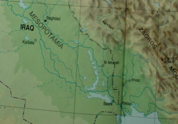
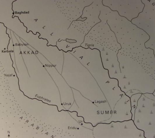
I find "most remarkable" the below map of modern Iraq (1990) showing _four streams_ crossing what was in Sumerian times the floodplain of Lower Mesopotamia. The Euphrates today breaks up into three streams as it crosses the floodplain and a branch of the Tigris "wanders westward" across the same plain of what was once ancient Sumer. That is to say, some 5,000 years later, Lower Mesopotamia is crossed again by four streams (Note on the below map"the recently built" canal northwest of Baghdad linking the Euphrates and Tigris) ! (for the below map cf. p.12. Michael Roaf. Cultural Atlas of Mesopotamia and the Ancient Near East. New York. Facts on File. 1990. ISBN 0-8160-2218-6).
As the reader is probably well aware there are "other" proposals for Eden's river and its four streams. Dr. Juris Zarins suggested in the 1980's that the Pishon was Wadi al-Batin in modern day Saudi Arabia, feeding into the Shatt al-Arab from the West. Other streams feeding into the Shatt al-Arab are the Euphrates and Tigris at Qurnah where they meet to form this waterway, and the Karkun ( Zarin's Gihon) from the Zagros mountains of Iran which meets the Shatt al-Arab on its east side. He located the garden of Eden under the Persian Gulf near the mouth of the Shatt al-Arab. His theory is frequently encountered at various Christian Websites. The problem? The four streams, the Wadi al-Batin, Euphrates, Tigris and Karkun are emptying into one stream, the Shatt al-Arab, _contrary to_ Genesis' notion of one stream becoming four streams. That is to say he has four streams becoming one.
Of late, David Rohl has captured the public's attention (David Rohl. Legend-The-Genesis-of-Civilisation. London. Century [imprint of Random House, United Kingdom]. 1998. ISBN 071267747X.) and has proposed that Eden's garden is in northern Iran near Tabriz and lies in a valley called the Adji Chay. For him, Eden's four rivers are the Gaihun/Aras (Gihon), the Kezel Uizhun (Pishon), the Tigris (Hiddekel) and Firat (Euphrates); however, not all emanate from one river as portrayed in Genesis, each arises from separate headwaters in the mountains between Lake Urmia and the Caspian Sea (modern Armenia, Kurdistan and Azerbaijan).
One can also encounter a number of Christian websites claiming that Eden's river and its four streams will never be found because Noah's Flood destroyed these rivers and their beds. This of course, is nonsense, as Archaeology and Geology have demonstrated that no universal or even regional flood ever occured in the Ancient Near East in 3rd millennium B.C. said date being suggested by the Bible's chronology.
Eden is probably ultimately derived from Sumerian _edin_ meaning "plain," or "steppe" and this plain is not exclusively the Lower Mesopotamian "flood-plain," its also the "high plain" of Northern Mesopotamia, from Haran to ancient Sippar. The "river of Eden" is the Euphrates in the high plain (Sumerian: an edin) of Northern Mesopotamia. The "garden _in_Eden" planted by God was then, apparently in Northern Mesopotamia, perhaps at Bit Adini, (associated by some scholars with Isaiah's bene Eden in Tel-assar [Isa 37:12]) or even perhaps 18th century B.C. Mari where exists a mural showing two trees guarded by fabulous winged beasts, the possible precursors of the Cherubim. The river's four streams are perhaps recalling the Euphrates breaking up into numerous watercourses as it meanders across the Lower Mesopotamian flood-plain or Sumerian _ki edin_ and its outflow into the Tigris in the 5th-4th millennium B.C.
However, the "origins" of the concept of gods making man, leaving him naked to roam edin-the-steppe with wild animals for companions is probably Sumerian and Mesopotamian. So too is the notion that the gods "made man" to tend and till their gardens which they had planted next to their cities _before_ man was created. There is a caveat though, Leick has sounded a warning that some Amorite notions appear in the Sumerian myths. The notion that a naked man wanders edin-the-steppe, _if_ it is the high plain of Northern Mesopotamia, "might" be a "marker or clue" that this may ultimately be an Amorite concept grafted into Lower Mesopotamian myths in the 4th-3rd millenniums B.C. when Semitic peoples from Amurru ("the West") settled in Sumer! Of interest here is Professor Clay's proposal (1919) that some of Genesis' motifs appeared to be Amorite in origin.
Clay:
"The first battery against the prevailing view that the Hebrews had borrowed their religious traditions from Babylonia, was opened up in the Reinicker Lectures, for 1908...resulting in a publication entitled Amurru the Home of the Northern Semites, a Study Showing that the Religion and Culture of Israel are not of Babylonian Origin." (cf. Albert T. Clay. The Origin of Biblical Traditions, Hebrew Legends in Babylonia and Israel. New Haven. Yale University Press. 1922. Yale Oriental Series. Researches. Vol. XII)
These originally Sumerian motifs apparently "migrated" northwest up the Euphrates (or southeast down the Euphrates with the Amorites according to Clay?) to the high plain between Sippar and Haran and took root in the trade centers established in this area by Lower Mesopotamians in the 4th-3rd millenniums B.C.
Israel traced her ancestors, Terah and Abraham to two regions, Ur of the Chaldees in ancient Sumer in Lower Mesopotamia's flood-plain (the source of the legends about the gods making man to toil in their gardens), and Haran in the high plain or steppe of Northern Mesopotamia.
I understand that Genesis was written in the Exile circa 560 B.C., by one author who used earlier compositions and traditions, mixing a 6th century BCE world with that of the 5th millennium B.C. He correctly recalled his ancestor's traditions about a river rising in Eden and watering a garden there (Mari had date palm plantations near the Euphrates via irrigation projects) and its breaking up into four streams later.
The notion that Noah's 3rd millennium B.C. Flood erased Eden's river courses is nonsense, as archaeology reveals no worldwide flood ever happened from the 12th millennium B.C. to modern times.
In the Bible a "river" is the source of water for God's garden which he placed man in to till and keep. Some Mesopotamian myths portray the gods building cities to dwell in and planting gardens to provide food for themselves. Later, "man is made" to toil in their gardens giving the "junior gods" (the Igigi) eternal rest from agricultural toil in the god's gardens as already enjoyed by the "senior" gods (the Annunaki). The principal source of freshwater for "the gardens of gods" near the cities in which the gods dwelt, in Akkad and Sumer, was the Euphrates river and its various streams which crisscrossed the flood-plain of Lower Mesopotamia.
Because the Euphrates was the only supplier of water to the god's gardens, I understand that "Eden's river" which watered Yahweh-Elohim's garden is the Euphrates. And Genesis' notion that a god places man in his garden to care for it is also drawing from Mesopotamian creation myths explaining why man was created
The importance of the Euphrates to "Southern Mesopotamia" (emphasis mine in CAPITALS):
Saggs (Professor Emeritus of Semitic Languages, University College, Cardiff, Wales):
"North and south Mesopotamia differ in climate and in natural resources. The north has stone and various minerals, and much of it enjoys rainfall normally sufficient to grow crops of corn [wheat]. Southern Mesopotamia, beginning at about Hit on the Euphrates and north of Baghdad on the Tigris, comprises the delta of the two rivers. Everywhere the soil is alluvial silt, stone is wholly lacking until well out into the western desert, and the rainfall, at less than 150 mm (6 inches) per year, is inadequate to support permanent vegetation cover. However, because of the rivers the region is not totally arid. The river friinges are well watered and productive, with belts of willow and poplar and dense thickets of tall grass, rushes and tamarisk and other undergrowth. Between Nasariyah on the Euphrates and Amara on the Tigris there is a vast region of marsh, with beds of giant reeds, and lakes full of fish and water birds. Wherever canals are cut from the rivers for irrigation, vegetation can be lush. But such luxuriance is the exception, and today the greater part of the region is, unless irrigated, desert except for a brief carpet of verdu from spring storms...The ruins of most of the earliest cities lie in regions which are now markedly arid, and one may wonder how civilization could begin in such adverse conditions. In fact it did not; EVERY CITY OF SOUTH MESOPOTAMIA ORIGINALLY LAY ON A MAJOR CHANNEL OR STREAM OF THE EUPHRATES, which has since shifted...Finds of Paleolithic stone tools in north Iraq proves the existence of humans there from about 100,000 B.C., and small camps or settlements from about 9000 B.C. show the early stages of change from total dependence on hunting and gathering, towards the domestication of animals and exploitation of cereal plants. We do not know when the first humans arrived in south Mesopotamia. Archaeology can trace farming settlements there only from the mid-sixth millennium, but it could have been the haunt of hunters, fishers and nomadic pastoralists many millennia earlier, without their leaving evidence traceable by present archaeological techniques.
Because of the behavior of the Euphrates over the preceding millennia, the first human comers would have found a region much more inviting and less arid than now. Besides several major channels of the Euphrates (THERE WERE STILL AT LEAST THREE IN THE THIRD MILENNIUM), there would have been many more minor streams and ditches, and swamps like the present southern marshlands. Such conditions produced more vegetation than now, so that the region was not only highly favourable for hunting, fishing and cattle rearing, but also offered easy possibilities for any settlers who broght with them a tradition of growing grain crops; they had only to sow their grain on the dry levees of former river-banks, and it would produce crops with minimal further attention until harvest. As population increase called for bigger harvests, the settlers could easily increase the area of cornland [wheat-land] by digging ditches to drain strips of wet land, and using those ditches -primitive canals- to bring water to further strips of land which were otherwise too dry. These were the small beginnings, but they began the process which over the millennia gave the world such great ancient cities, known from the Bible, as Uruk (Erech of Genesis 10:10), Ur of the Chaldees and Babylon." (pp. 8-9. "The Rediscovery of Babylonia." H. W. F. Saggs. Peoples of the Past: Babylonians. Berkeley, California. University of California Press. 2000 [The Trustees of the British Museum, London]. ISBN 0-520-20222-8)
Saggs' description of Southern Mesopotamia as being pretty much an arid region with the exception of the water from the Euphrates, recalls to my mind Genesis' description of the earth as arid and without water until God provided a river to water his garden. Saggs also noted that ancient cities of this region received their water for their gardens of the gods principally from one source, a river, the Euphrates. In Genesis it is a river that waters God's garden. In the temple of Solomon at Jerusalem the walls were decorated with Cherubim and Palm Trees (1 Kings 6:32, 35; 7:36), I note that Date Palm plantations or orchards line the banks of the Euphrates and its streams or channels throughout this region. Date Palms also appear on a wall mural at ancient Mari on the Euphrates guarded by fabulous winged beasts. Archaeologists have found the remnants of the canals and irrigation ditches about Mari which made these Date Palm plantations possible.
Also of interest is Saggs' comment about the Euphrates possessing THREE channels or streams in the third millennium BCE (However his map, cf. above, shows FOUR channels or stream beds). Factoring this in with Roaf's, Pollock's and Leick's observation that in the 4th milllennium BCE the Euphrates split from the Tigris, we have four streams crossing the floodplain in antiquity. Are these the four edenic streams recalled in Genesis? When the Tigris is factored in with the Euphrates' three channels (due to the latter's discharge into the former) we have the four rivers of Eden (edin).
There is a "caveat" here, if the above maps are merely showing a "migrating" Euphrates river leaving behind over the millennia, three or four empty riverbeds, then the notion that it at one time split into three or four channels that were contemporary with each other is invalid, and these ancient beds have nothing to do with the four rivers of the Edenic River.
Dr. Oates (of the McDonald Institute for Archaeological Research in Cambridge, England) noted that at NO time was the Euphrates a SINGLE stream in crossing this region, but that it was as many as FOUR streams in the 3rd millennium BCE. She apparently understands that the Sumerian word _edin_, which she translates as "open desert" is applicable to this area (Note Genesis' description of Eden as being ARID and without water before God created a river to water this area and his garden aligns somewhat with Oates' observation of edin meaning "desert" as in the "desert-plain" of Lower Mesopotamia):
"In Babylonia settled occupation outside the marshes occurred, of necessity, along the water-courses, tending to concentrate in areas favourable for irrigation, separated by long stretches where the river ran through desert or swamp. This pattern produced in ancient Sumer two groups of cities separated by AN AREA OF OPEN DESERT KNOWN IN SUMERIAN AS _THE _EDIN_...The sluggish Euphrates, with its relatively high bed, provided a more easily exploited source of irrigation water than the faster-flowing Tigris; thus the earliest vilages yet known in Sumer -Ur, Eridu and Uruk (Warka)- are found along its course." (p. 12. "Introduction." Joan Oates. Babylon. London. Thames & Hudson. 1979, 1986. ISBN 0-500-27384-7)
"Archaeological surveys and historical sources both confirm this pattern of shifting water-courses and associated concentrations of population. They also indicate the later maintenace of SOME ORIGINALLY NATURAL WATER CHANNELS AS 'CANALS'. It is clear too THAT AT NO TIME DID THE EUPHRATES OCCUPY ONE SINGLE CHANNEL. In the earliest period for which we have evidence there seem to have been THREE MAJOR BRANCHES, running respectively through Kish, Cutha, and Jamdat Nasr, settlement apparently having been heaviest along the easternmost branch. By the 3rd millennium the Kish channel was undoubtedly the most important, just as Kish was the major city. The earliest documentation for the then apparently minor BABYLON BRANCH comes later in the 3rd millennium; it was not until the end of the 2nd millennium that this channel became the most important of the Euphrates courses. It remains today an impressive river, although the main Euphrates channel now flows even further to the west." (p. 13. Joan Oates. Babylon. London. Thames & Hudson. 1979, 1986. ISBN 0-500-27384-7)
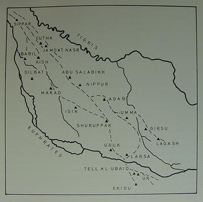
Below, Oates' map showing with dotted lines FOUR streams or channels of the Euphrates in the 3rd millennium BCE; the present modern day courses of the Tigris and Euphrates are rendered in solid lines.
Stream 4: Sippar, Jamdat Nasr (cf. p. 13. map titled "Map of Southern Iraq 3rd Millennium Courses of the Euphrates." Joan Oates. Babylon. London. Thames & Hudson. 1979, 1986. ISBN 0-500-27384-7).
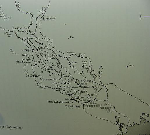
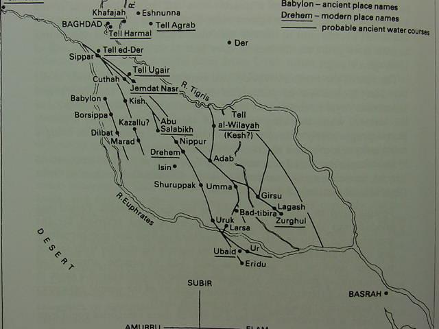
Below, Professor Saggs' map shows that _all_ of the cities of ancient Akkad and Sumer with the exception of Larak drew their water from ONE RIVER, the Euphrates and its channels. To the degree that Genesis understands ONE RIVER waters God's garden in Eden, and some Mesopotamian myths state that the gods made man to tend and till their gardens which they had planted next to their cities (built before man's creation), AND Sagg's observation that ALL the cities of Southern Mesopotamia derived their water from ONE RIVER, the Euphrates, I see the below FOUR channels or streams (dotted lines) as recalling the Edenic river dividing into four streams (Note: He shows the "modern-day course" of the Euphrates and Tigris in solid lines). The four ancient river beds of the Euphrates' channels on the below map: Stream 1: Sippar, Agade, Babylon, Borsippa, Dilbat, Isin; Stream 2: Agade, Kish, Nippur; Stream 3: Kutha, Tell Abu Salabikh, Adab; Stream 4: Kutha, Tello/Girsu, Lagash, Surghul/Nina (For the map cf. p. 181. H. W. F. Saggs. Peoples of the Past: Babylonians. Berkely, California. University of California Press. 2000 [The Trustees of the British Museum, London]. ISBN 0-520-20222-8)
Although Saggs' map shows the Euphrates subdividing into four streams or channels he has noted that as many as
_six channels_ (perhaps even more?) existed in ancient times:
"In southern Mesopotamia...most settlements were associated with the Euphrates. The Euphrates had at least six major channels, some of them further subdivided, and some flowing into lakes or disappearing into marshes..."
(p. 37. "City-States and Kingdoms." H.W.F. Saggs. Civilization Before Greece and Rome. New Haven & London. Yale University Press. 1989)
Of interest here with Oates' above understanding that in the 3rd millennium B.C. the Euphrates had divided itself into four streams as it crossed edin, is that some biblical scholars understand that the Israelite Patriarch Abraham had been born at Ur of the Chaldees circa 2166 B.C., in the SAME MILLENNIUM that the Euphrates had become FOUR water courses.
Finegan (Professor Emeritus of New Testament History and Archaeology at the Pacific School of Religion in Berkeley, California):
"Isaac's father Abraham was 100 years old when Isaac was born (Gen. 21:6), therefore Abraham was BORN IN 2166 (2,066+100=2,166). Abraham was 75 years of age when he went on from Haran to Canaan (Gen 12:4), therefore he came to Canaan in 2091 (2,166-75=2,091)."
(pp. 201-202. Jack Finegan. Handbook of Biblical Chronology. [Revised Edition]. Peabody, Massachusetts. Hendrickson Publishers, Inc. First Edition 1964 Princeton University Press. 1998, 1999. ISBN 1-56563-143-9)
Is it just possible that Abraham _really existed_ in the 3rd millennium B.C. and that through him the notion that a river "in Eden" watered a God's garden and subdivided into four streams ? As a native of Ur of the Chaldees (Modern Tel al-Muqayyar according to some scholars) he would know of these four channels or water-courses or streams. He may have crossed some of them in his migration to Haran, following the Euphrates into Northern Mesopotamia. It would be his descendants who centuries later would transform the Euphrates and its four streams into Genesis' Edenic river.
The late Professor Kramer, a prominent Sumerologist (Curator Emeritus of the Tablet Collection at the University Museum of the University of Pennsylvania, and Clark Research Professor Emeritus), on Abraham possibly being "the source" of some of Genesis' notions which appear to be reflected in Mesopotamian beliefs:
"To be sure, even the earliest parts of the Bible, it is generally agreed, were not written down in their present form much earlier than 1000 B.C., whereas most of the Sumerian literary documents were composed about 2000 B.C. or not long afterward. There is, therefore no question of any contemporary borrowing from the Sumerian literary sources. Sumerian influence penetrated the Bible through the Canaanite, Hurrian, Hittite, and Akkadian literatures -particularly through the latter, since, as is well known, the Akkadian language was used all over Palestine and its environs in the second millennium B.C. as the common language of practically the entire literary world. Akkadian literary works must therefore have been well known to Palestinian men of letters, including the Hebrews, and not a few of these Akkadian literary works can be traced back to Sumerian protoypes, remodeled and transformed over the centuries.
However, there is another possible source of Sumerian influence on the Bible, which is far more direct and immediate than that just described. In fact, it may well go back to Father Abraham himself. Most scholars agree that the Abraham saga as told in the Bible contains much that is legendary and fanciful, it does have an important kernel of truth, including Abraham's birth in Ur of the Chaldees, perhaps about 1700 B.C., and his early life there with his family. Now Ur was one of the most important cities of ancient Sumer; in fact, it was the capital of Sumer at three different periods in its history. It had an impressive edubba; and in the joint British-American excavations conducted there between the years 1922 and 1934, quite a number of Sumerian literary documents have been found. Abraham and his forefathers may well have had some acquaintence with Sumeriabn literary products that had been copied and created in their home town academy. And it is by no means impossible that he and the members of his family brought some of this Sumerian lore and learning with them to Palestine, where they gradually became part of the traditions and sources utilized by the Hebrew men of letters in composing and redacting the books of the Bible."
(p. 292. "The Legacy of Sumer." Samuel Noah Kramer. The Sumerians, Their History, Culture, and Character. Chicago. The University of Chicago Press. [1963] reprint 1972. ISBN 0-226-45237-9. paperback)
I note that extra-biblical evidence suggests a Jewish understanding from as early as the Hasmonean period (late 2nd century B.C.), that the Israelite forefathers were indeed originally of Babylonia, and only later of Haran of Mesopotamia and that because they had departed from the forms of worship embraced by their ancestors, they were apparently driven away as heretics to Haran and later to Canaan. If I am right in suppossing that the "INVERSIONS, transformations and reformatting" of the Mesopotamian myths are Terah and Abraham's doing, one can see why they would be "driven out" of Ur of the Chaldees by the local inhabitants who would object to their religious myths being NULLIFIED by the "revelations" of these two men.
Here is the account from Judith (believed by some scholars to date from the late 2nd century B.C.):
Judith 5:5-9
"Then Achior, the leader of all the Ammonites, said to him, "Let my lord now hear a word from the mouth of your servant, and I will tell you the truth about this people that dwells in the nearby mountain district. No falsehood shall come from your servant's mouth. This people is descended from the Chaldeans.At one time they lived in Mesopotamia, because they would not follow the the gods of their fathers who were in Chaldea. For they had left the ways of their ancestors, and they worshipped the God of Heaven, the God they had come to know; hence they drove them out from the presence of their gods; and they fled to Mesopotamia, and lived there a long time. Then their God commanded them to leave the place were they were living and go to the land of Canaan. There they settled, and prospered..." (Herbert G. May & Bruce M. Metzger. Editors. The New Oxford Annotated Bible with the Apocrypha. [Revised Standard Version]. New York. Oxford University Press. 1977)
Ezekiel's "Eden" (Ez 27:2, 22-23) RSV:
"Now you, son of man, raise a lamentation over Tyre, and say to Tyre, who dwells at the entrance to the sea, merchant of the peoples on many coastlands...Haran, Canneh, _EDEN_, Asshur, and Chilmad traded with you."
Below, Aharoni and Avi-yonah's "Beth-Eden" transformed into Ezekiel's Eden. (cf. p. 89. Map number 116. "The Trade of Tyre, 10th to 7th Centuries B.C." Yohanan Aharoni & Michael Avi-Yonah [Anson Rainey, editor]. The Macmillan Bible Atlas. Carta, Jerusalem & Macmillan of New York. [Revised 3rd Edition] 1968, 1977, 1993. ISBN 0-02-500605-3)
It is my understanding that the ONE river _in_ Eden which arose and watered God's garden is the Euphrates, the SAME river which is also responsible for watering _ALL_ the "gardens of the gods" adjacent to the cities _in_ Lower Mesopotamia in the form of FOUR streams no later than the 3rd millennium B.C.
The city of ancient Mari (18th century B.C.) lay on the Euphrates just west of the "E" in Euphrates on the above map. It had irrigation networks for Date Palm gardens. On the palace walls two trees appear guarded by three fabulous beasts, two of which are winged, a goddess in the garden raises her hands in praise.
If I am correct in proposing the Euphrates is the river _in_ Eden (Ezekiel's Eden?) south of Haran where Abraham and Jacob roamed from, and that the Euphrates' four streams are the four rivers of Eden, where then lies the Pishon and Gihon and the lands associated with them, Havilah and Cush?
Some scholars have suggested Havilah may be related to Hebrew hol, meaning "sandy" which might describe the great desert of Arabia west of the Euphrates from Ezekiel's Eden to the "desert-edins" of Lower Mesopotamia interspersed between the Euphrates' four channels (as noted by Oates). Cush, pronounced Kush has been related to several toponyms by various scholars: the Kassites who ruled Babylonia who were called in Akkadian Kashshu, or possibly one of the leading cities of Lower Meopotamia, Kish; or even the Hellenstic Greek Cossae, modern Khuzistan in western Iran abutting the Mesopotamian flood-plain. It has been noted by some scholars that Nimrod is portrayed as a son of Cush who established an empire in Babel (Babylon ?), Erech (Uruk), and Accad (Akkad) in the land of Shinar. Thus Cush appears to be associated in the Bible with two different locations, Egypt and Babylonia. Havilah appears to be a South Arabic tribe associated with Sheba in Genesis. But "if" Hebrew hol, "sandy" is allowed as a possible etymology for Havilah, perhaps the Arabian desert abutting the Euphrates was the original location? As regards the Pishon, the Hellenistic Greeks called a portion of the Tigris the Pasi-tigris, could this preserve Pishon?
Another possible solution for the location of the Pishon and Havilah is that it is wadi Baish near the Yemen and the region of Haulan, northwest of San'a. The Gihon would then be the Nile in Cush (Sudan). How would these far-off rivers link with the Euphrates and Tigris? Perhaps stage 1) was a river becoming four streams, the Euphrates and its branches under Abraham's influence (?); stage 2) Perhaps Kashshu, Kish or Cossae/Khuzistan became "confused" with Cush (Sudan) causing the transfer of location? or perhaps faraway unrelated rivers are included due to 7th century B.C. Hebraic embellishment or hyperbole: "Eden's river is the source of all great rivers despite their location." There is a history behind this notion. The Sumerians understood that an underground ocean called the Apsu or Absu was the source of all rivers via springs. The Hebrews had their tehom or "underground waters" as a source of Eden's river and all rivers. The Greeks had a notion of a mythical freshwater River Ocean (Homer) that encircled the world and was the source of all the world's rivers (via underground rivers which connect to the world river). Perhaps this Greek notion explains Flavius Josephus' (1st century A.D.) notion that the river of Eden encircles the world and is the source of all rivers? Perhaps Greek mercenaries serving in king Josiah of Judah's armed forces introduced the Jews to the Homeric notion of "River Ocean" and they adapted it to an Edenic river? They apparently adapted the Greek mercenaries' Titan Iapetos and Deucalion's Flood to their traditions of a Flood traced to Shuruppak in Mesopotamia circa 2900 B.C. They also apparently accepted the Greek notion that the Medes were descendants of Iapetos via Medus the son of Aeetes of Athens and Medea of Colchis. So, the 7th-6th centuries B.C. could be the source of several Greek concepts entering Genesis' portrayal of the world? Greek mercenaries served not only in Josiah's army they also served in the armies of the Saitic Pharaohs who put and end to Josiah and they served in Nebuchadrezzar's army too.
Below: Aharoni and Avi-Yonah's proposal for the location of the "rivers of Eden" (Emphasis mine):
"It is natural that the ancients should believe the rivers of Eden to be those flowing through the lands most abundant in water, the foremost being the Tigris and Euphrates in Mesopotamia. The Pishon and the Gihon have not been identified and may have merely been symbolic. But since HAVILAH is one of the regions of CUSH (Gen. 10:7), it would seem that the two major brances of the Nile (the Blue and the White) are intended." (cf. p. 21. Map number 14. "The Rivers of the Garden of Eden." Yohanan Aharoni & Michael Avi-Yonah [Anson Rainey, editor]. The Macmillan Bible Atlas. Carta, Jerusalem & Macmillan of New York. [Revised 3rd Edition] 1968, 1977, 1993. ISBN 0-02-500605-3)
Genesis 10:6-7 RSV
"The sons of Ham: Cush, Egypt, Put, and Canaan. The sons of CUSH: Seba, HAVILAH, Sabtah, Raamah and Sabteca. The sons of Raamah: Sheba and Dedan."
Note: In the Middle Ages some Jewish scholars thought Ethiopia was Havilah, and that Eden lay somewhere south of that location, as they identified the Nile with the Geon. The Greek translation of the Hebrew Bible called the Septuaginta (3rd century BCE) identified the Gihon/Geon with the Nile as did the 2d century B.C. Hasmonean Book of Jubilees.
The temple of Solomon had on its walls Cherubim and Palm Trees (1 Kings 6:32, 35), these trees do not grow in the Taurus or Zagros mountain ranges where Rohl locates his Eden and its rivers. The winter snows would kill the trees. So his proposed location "ought" to fit the facts, Palm Trees should be able to thrive. They do exist, however, in the thousands in Lower Mesopotamia, watered by the Tigris and Euphrates on the plain. They also exist on the Euphrates at Mari, where a wall mural shows three fabulous beasts guarding the two trees. To the west of Mari lies Bit-Adini (Beth-Eden) identfied as Ezekiel's Eden that traded with Tyre. So the Euphrates river flows _from_ Beth-Eden/Eden to Mari, watering the goddess' Date Palm garden, worked by men, and thence on to the Mesopotamian plain to water the "gardens of the gods" and their thousands of Date Palms, still grown in plantations today.
Ezekiel does speak of the "Cedars of Eden" envying Pharaoh as a great towering Cedar (Ez 31:9-18). This "Cedar connection" would favor Rohl's mountainous Eden. The problem? Solomon's temple is decorated with Palm Trees and Cherubim _not_ Cedar Trees (although it has a cedar beam roof, walls and doors). So, actually, Ezekiel's mountainous Eden with its Cedars _contradicts_ the Temple's Palm Trees which are not a mountain growing species. How to reconcile the two species and their locales? This is another example of an amalgamating of different _impossible locales_, just like the wadi Baish (Pishon?) in the Yemen and Euphrates in the Mesopotamian flood plain. The Ziggurats next to the gardens of the gods in the Mesopotamian flood-plains are part of the story behind Ezekiel's Cedar mountain of Eden. Ziggurats were artificial mountains, recalling the ancestors who first lived in the Taurus and Zagros ranges before settling the flood-plain. Plain is rendered edin in Sumerian, so it is _unlikely_ edin is the mountains Rohl favors for his Eden. Naked man would freeze in the mountains, but he could survive in the plain, living off the Date Palms, and they also exist in the Sudan near the Nile (Gihon?) and in the Yemen at lower elevations.
The Pishon is probably Wadi Baish or the nearby Wadi Bish northwest of San'a the capital of the Yemen, Havilah being the region called Haulan (as noted by W. W. Muller, "Pishon." Vol. 5, p. 374. David Noel Freedman. Editor. The Anchor Bible Dictionary. 1992. Doubleday).
I am unaware of any Egyptian, Phoenician, Amorite (Ugaritic), Hittite or Mesopotamian myths claiming all rivers emanate from one stream. ONLY THE HOMERIC GREEKS HAVE THIS NOTION. Ezekiel has tehom sending its water from under the earth to form a river to water the garden of Eden. How can a Gihon/Nile in Cush/Sudan and a Pishon/wadi Baish in Haulan/Havilah (Yemen) be connected to the Euphrates ? Its impossible ! Its also impossible for Eden to have Palm Trees and Cedar Trees guarded by Cherubim, as these grow in different locations. But a Homeric "Freshwater River Ocean," source of all rivers via underground streams could accomplish the impossible ! If "River Ocean" is the source of a Geon (Nile) and Pishon (Wadi Baish near the Haulan of Yemen), perhaps the Jews picked this notion up from either Greek merchants/traders or Greek mercenaries present in Judah circa the 7th and 6th centuries B.C. (I understand Genesis was composed ca. 560 BCE in the Exile)? Archaeologists have found evidence of Greek wares in Judah in these eras and excavated a couple of fortresses suggesting that Josi'ah of Judah may have even had Greek mercenaries in his army at this time. Thus the "Pre-Exilic" Jews of Judah might have been aware of River Ocean as a source of all the world's streams from either Greek merchants or mercenaries. Homer is believed by some scholars to have been an Ionian of Asia Minor (present day Turkey) and Ionians are known to have served as mercenaries in the 7th century B.C. armies of the Saitic pharaohs who defeated Josiah (2 Kings 23:29-30) and hauled his successor, Jehoahaz, off to Egypt in chains (2 Kings 23:30-34), appointing a new king of Judah, Jehoiakim in his place (2 Kings 23:34-35). Perhaps the Greek mercenaries at Tell Arad were left by Necho to "ensure" the collection of tribute from Jehoiakim (2 Kings 23:33--35)? That is to say, either Greek mercenaries hired by Josiah or left in Judah by Pharaoh Necho to keep Jehoiakim "in line," _may have been the source_ of a Freshwater River Ocean being the source of all the world's rivers ? Please click here for a further discussion of the Homeric River Ocean as the source of _all_ the world's rivers.
Some scholars have even suggested that Genesis' narrator was playfully _signaling_ his "sophisticated" audience with an impossible scenario of these rivers arising from one stream that all this Edenic stuff was "fantasy" and to be regarded merely as a make-believe story or fairy-tale. The problem? I doubt the audience was that "sophisticated." Perhaps some of the well-educated were acquainted with the distances involved and realized all this was "tongue-in-cheek" playfulness? If so, how sad that millions have believed this "tongue-in-cheek" fairy-tale and have killed and died for it.
Why waste my time arguing for Eden's four streams arising from one as recalling the Euphrates and its four streams during the course of the 6th through early 2nd millenniums B.C. if the Pishon is Wadies Baish in the Yemen and Bishah of Asir in Saudi Arabia, the Gihon being either the Nile in the Sudan or possibly Wadi Aqiq east of Medina?
Because I believe several traditions have been fused together.
The 6th through early 2nd millennium B.C. recollection of the Euphrates having four streams was probably transformed in the 7th/6th century B.C. into a river in Cush/Sudan and a river in the gold fields of Arabia, the Wadi Baish/Bishah of Haulan/Havilah. This transfer suggested itself in noting a Cush was the father of Nimrod in Babylon. So a Cush (Sudan) or a Harrat Kishb and its wadi Aqiq of Saudi Arabia and a Cush (the city of Kish? The Kassites? or the Kossae?) in Lower Mesopotamia were possibly utilized to "transfer" one of the 2nd millennium B.C. streams from Mesopotamia to Africa/Arabia in the 7th/6th century B.C. The Homeric (Ionian Greek) notion that _ALL_ the rivers of the world derive from one river may possibly have faciliated the connection between the Mesopotamina Cossae and Egyptian Cush/Kush (today's Sudan), making the Nile the Geon as preserved in the Septuaginta Bible of the 3rd century B.C.
Inscriptions in Ionian Greek, left presumably by Ionian mercenaries in Cush at Abu Simbel may explain why Genesis has a single river the source of a stream (Geon) in Cush and Tigris and Euphrates in Mesopotamia; Ionian mercanaries probably also served on the Euphrates under Pharaoh Necho at Car'chemish (Jer 46:2-6), and note the allusion to Egypt's "hired soldiers" by Jeremiah (Jer 46:21).
Ray noted that Ionians and Carians were probably in Egypt, serving Pharaoh Psammetichus I (664-610 B.C.) in the 7th century B.C.:
"Carians, together with their Ionian cousins, soon migrated to the banks of the Nile. Herodotus (2.152) dates their arrival to the early years of Psammetichus I, whose reign began about 664...This early date for the Carian's arrival is confirmed by the account of the military historian Polyaenus (2nd century B.C.E.) and archaeolgy suggests that it was in this period that the settlement of Naukratis was first established as an emporium for traders from the Aegean...In 593, Psammetichus II, grandson of the founder of the dynasty, undertook a major campaign into Nubia. This was a time-honored pharaonic custom, but on this occasion the Egyptian army included contingents of Ionians, Phoenicians, and Carians. On their return toward Egypt, they camped at the foot of the colossal statues of the temple of Abu Simbel...One of the Ionians left an inscription below the knee of the broken colossus south of the doorway; this is probably the earliest historical inscription in the Greek language anywhere. Carian inscriptions were also carved on the legs of this colossus."
(Vol. 2, pp. 1189-1190. John D. Ray. "Soldiers to Pharaoh: The Carians of Southwest Anatolia." Jack M. Sasson. Editor. Civilizations of the Ancient Near East. Peabody, Massachusetts. Hendrikson Publishers. [1995 Charles Scribner & Sons] reprint 2000 rebound into 2 vols)
The 6th century B.C. narrator of Genesis (it being written ca. 560 B.C.) was making an impossible claim that the great rivers of Africa, Arabia, and Mesopotamia were all derived from one stream which watered a God's garden. The 7th/6th century B.C. Ionian Greek mercenaries under Homeric influence, serving in the fortresses of Judah in the days of Josiah, Jehoahaz, and Jehoiakim, would have had NO PROBLEM, embracing Genesis' notion of ONE RIVER being the source of the Geon/Nile in Cush, the Pishon/Baish near Haulan in the Yemen and the Euphrates and Tigris in Mesopotamia.
Skinner (Professor of Old Testament Language and Literature, Westminster College, Cambridge, England) on Eden's geography not corresponding to any known geographical reality:
"...it is obvious that a real locality answering to the description of Eden exists and has existed nowhere on the face of the earth. The Euphrates and Tigris are not and never were branches of a single stream; and the idea that two other great rivers sprang from the same source places the whole representation outside the sphere of real geographical knowledge. In 10-14, in short, we have to do with a semi-mythical geography, which the Hebrews no doubt believed to correspond with fact, but which is based neither on accurate knowledge of the region in question, nor on authentic tradition handed down from the ancestors of the human race. Nevertheless, the question where the Hebrew imagination located Paradise is one of great interest; and many of the proposed solutions are of value, not only for the light they have thrown on details of 10-14, but also for the questions they raise as to the origin and character of the Paradise-myth."
(p. 62. "The Site of Paradise." John Skinner. A Critical and Exegetical Commentary on Genesis. Edinburgh. T & T Clark. 1910, revised 1930. reprint of 1994. ISBN 0567050017)
Skinner (1910) on the Euphrates' discharge into the Tigris, critiquing Delitzsch's proposal for Eden's rivers, which parallels somewhat my own notions presented here (emphasis mine in _italics_):
"Several recent theories seek an exact determination of the locality of Paradise...That of Freidrich Delitzsch (Wo lag das Paradies?, 1881) is based partly on the fact that north of Babylon (in the vicinity of Baghdad) the Euphrates and Tigris approach within some twenty miles of each other, _the Euphrates from its higher level discharging water through canals into the Tigris, which might thus be regarded as an offshoot of it._ The land of Eden is the plain (edinu) between the two rivers from Tekrit (on the Tigris: nearly a hundred miles north of Baghdad) and 'Ana (on the Euphrates) to the Persian Gulf; the garden being one specially favoured region from the so-called isthmus to a little south of Babylon. The river of verse 10 is the Euphrates; Pishon is the Pallakopas canal, branching off from the Euphrates on the right a little above Babylon and running nearly parallel with it to the Persian Gulf; Gihon is the Shatt en-Nil, another canal running east of the Euphrates from near Babylon and rejoining the parent river opposite Ur; Hiddekel and Euphrates are, of course, the lower courses of the Tigris and Euphrates respectively, the former regarded as replenished through the canal system from the latter. Havilah is part of the great Syrian desert lying west and south of the Euphrates; and Kush is a name for northern and middle Babylonia, derived from the Kassite dynasty that once ruled there. In spite of the learning and ingenuity with which this theory has been worked out, it cannot clear itself of an air of artificiality at variance with the simplicity of the passage it seeks to explain. That the Euphrates should be at once the undivided Paradise-stream and one of the heads into which it breaks up is a glaring anomaly; while _verse 14 shows that the narrator had distinctly before his mind the upper course of the Tigris opposite Assur, and is therefore not likely to have spoken of it as an effluent of the Euphrates._ The objection that the theory confuses rivers and canals is fairly met by the argument that the Babylonian equivalent id is used of canals [id is used of a canal as well as a river], and also by the consideration that both the canals mentioned were probably ancient river-beds; but the order in which the rivers are named tells heavily against the identifications. Moreover, the expression 'the whole land of Havilah' seems to imply a much larger tract of the earth's surface than the small section of desert enclosed by the Pallakoppas; and to speak of the whole of northern Babylonia as 'surrounded' by the Shat en-Nil is an abuse of language."
(p. 62. "The Site of Paradise." John Skinner. A Critical and Exegetical Commentary on Genesis. Edinburgh. T & T Clark. 1910, revised 1930. reprint of 1994. ISBN 0567050017)
Skinner critiques Sayce's and Hommel's proposals that Eridu is Eden and the river of Eden is the Persian Gulf:
"According to Sayce...the garden of Eden is the sacred garden of Ea at Eridu; and the river which waters it is the Persian Gulf, on the shore of which Eridu formerly stood. The four branches are, in addition to the Euphrates and Tigris (which in ancient times entered the Gulf separately), the Pallakopas and the Choaspes (now the Kerkha), the sacred river of the Persians, from whose waters alone their kings were allowed to drink (Herodotus 1.188). Besides the difficulty of supposing that the writer of verse 10 meant to trace the streams upwards toward their source above the garden, the theory does not account for the order in which the rivers are given; for the Pallakopas is west of the Euphrates, while the Choaspes is east of the Tigris. Further, although the description of the Persian Gulf as a 'river' is fully justified by its Babylonian designation as Nar Marratum ('Bitter River'), it has yet to be made probable that either Babylonians or Israelites would have thought of a garden watered by 'bitter' (i.e. salt) water. These objections apply with equal force to the theory of Hommel...who agrees with Sayce in placing Paradise at Eridu, in making the single stream the Persian Gulf, and one of the four branches the Euphrates. But the other branches, Pishon, Gihon, and Hiddekel, he identifies with three north Arabian wadies: Wadi Dawasir, Wadi Rumma, and Wadi Sirhan (the last the 'wadi of Diklah'= had-dekel...the name having been afterwards transferred to the Tigris."
(p. 63. "The Site of Paradise." John Skinner. A Critical and Exegetical Commentary on Genesis. Edinburgh. T & T Clark. 1910, revised 1930. reprint of 1994. ISBN 0567050017)
Skinner on the Armenian mountain as sources of the Tigris and Euphrates and Eden's site:
"Since none of the above theories furnishes a satisfactory solution of the problem, we may as well go back to what appears the natural interpretation of verse 10, and take along with it the utopian conception of four great rivers issuing from a single source. The site of Paradise is then determined by the imaginary common source of the two known rivers, Euphrates and Tigris. As a matter of fact, the western arm of the Euphrates and the eastern arm of the Tigris do rise sufficiently near each other to make the supposition of a common source possible to ancient cosmography; and there is no difficulty in believing that the passage locates the garden in the unexplored mountains of Armenia. The difficulty is to find the Pishon and the Gihon. To seek them amongst the smaller rivers of Armenia and Trans-caucasia is a hopeless quest; for a knowledge of these rivers would imply a knowledge of the country, which must have dispelled the notion of a common source."
(pp. 63-64. "The Site of Paradise." John Skinner. A Critical and Exegetical Commentary on Genesis. Edinburgh. T & T Clark. 1910, revised 1930. reprint of 1994. ISBN 0567050017
Skinner's conclusions:
"It seems probable that the resources of philology and scientific geography are well-nigh exhausted by theories such as have been described above, and that further advance towards a solution of the problem of Paradise will be along the line of comparitive mythology...the mention of the well-known Tigris and Euphrates clearly shows that the form of the myth preserved in Genesis 2:10-14 located the earthly Paradise in the unknown northerly region whence these rivers flowed. And the conclusion is almost inevitable that the myth took shape in a land watered by these two rivers, -in Babylonia or Mesopotamia."
(p. 65, 66. "The Site of Paradise." John Skinner. A Critical and Exegetical Commentary on Genesis. Edinburgh. T & T Clark.1910, revised 1930. reprint of 1994. ISBN 0567050017)
I have NO PROBLEMS with Skinner's penetrating analysis. Eden is a "myth" and cannot be pin-pointed to a single location (its a fusion of several locations in contradicting Mesopotamian myths). My research suggests a number of "motifs" from several Mesopotamian myths have been fused together by the Hebrews into Genesis' story of Eden and its inhabitants, Yahweh-Elohim, Adam, Eve and the Serpent. Please click here for the "multiple edens."
One of these "Edens" does lie in what Skinner calls "the unknown northerly region," that is to say, the Euphrates is a single river from just west of ancient Mari to Sippar, in northern Mesopotamia, where it broke up into four streams in the 3rd millennium BCE. Mari's 18th century B.C. mural shows fabulous beasts guarding two trees, and these motifs may lie behind Genesis' two forbidden trees and the Cherubim. That is to say, the Hebrew's notion that a single stream watered God's garden might recall Mari's Date Palm plantation as the Garden of Eden. However, the motifs of a god planting a garden and placing man in it to care for it appear to be preserved in myths regarding Enki's making of man to care for gardens located at Eridu and Nippur in the Lower Mesopotamian flood-plain. So, it would appear several locations have been fused together. The notion that one river was the source of the Euphrates and Tigris may be recalling the union of these two streams in the 6th-3rd millenniums B.C. and possibly even later, the discharge of the higher Euphrates into the lower Tigris via various channels and canals as late as the 19th century A.D.
A warning or "caveat":
The commonly encountered Christian claim that Noah's Flood destroyed the Edenic streams and their beds, thus Eden will never be located is _bogus_ nonsense. The disciplines of Geology, Archaeology and Anthropology have conclusively shown that there never was a 3rd millennium B.C. world-wide flood as suggested by the Bible's chronology. Settlements in the Near East have been dated back to the 12th millennium B.C. with no universal flood layer ever being found in Egypt, Canaan, Syria, or Mesopotamia. Noah's "mythical flood" has been _in my estimation_ correctly identified with the Shuruppak flood myth of Mesopotamia of the 2d millennium B.C. clay tablets written in cuneiform and archaeologists have dug up Shuruppak and found its flood occurred in the 3rd millennium B.C., circa 2900 B.C. at the close of the Jemdet Nasr Period. That is to say, the Bible has remarkably preserved the correct millennium for "The Flood" as the Shuruppak event did occur in the 3rd millennium B.C.! Thus Eden's rivers should be identifiable, as there was no world-wide flood to erase them. As noted by Skinner in 1930, no geographical location fits, this is embellished myth. Underlying this myth though, as noted by the German Assyriologist Friedrich Delitzsch (Wo Lag das Paradies? [Where Lay the Paradise?] Leipzig, Germany. 1881), is the Euphrates' breaking up into several streams in the Lower Mesopotamian flood-plain, and it is this archaeologically attested phenomenon which probably lies behind Eden's four rivers. Please click here for a "possible" Sumerian rendering of "Noah's Ark" circa 2600 B.C. on a bas-relief found at Shuruppak.
Some Christian scholars claim Eden's garden can never be found because Noah's flood destroyed the original beds of the Edenic rivers, burying them under tons of Flood sediment. Some Roman Catholic scholars date Noah's Flood to ca. 2958 B.C. while some Protestants claim the Flood was ca. 2348 B.C. Both dates fall in the 3rd millennium BC. The problem? According to Geologists and Archaeologists there is no evidence of a worldwide flood covering the earth's mountaintops in the 3rd millennium B.C. There is also no geological evidence that the Tigris (biblical Hiddekel) and Euphrates rivers ever arose from one river. The biblical portrayal of Eden's river system is then, fantasy. However a two foot deep flood deposit was found at Tell Fara (ancient Shuruppak) where, according to Mesopotamian myths the "Mesopotamian Noah" (variously called Ziusudra, Atrahasis or Utnapishtim) lived when told to build a boat to preserve the seed of animal and mankind from the coming flood. The uncultivated land contguous to the cities of Lower Mesopotamia (Sumer) was called in Sumerian the edin, and archaeologists did document that this edin about Shuruppak had been flooded circa 2900 B.C. So an edin (eden) was submerged under a flooding Euphrates, but not the whole world.
Easton back in 1897 remarked upon the great flood-plain of Lower Mesopotamia being the ONLY area where streams branch off from each other, reminiscent of Eden's river that subdivides into four streams:
"The site must undoubtedly be sought for somewhere along the course of the great streams the Tigris and the Euphrates of Western Asia, in "the land of Shinar" or Babylonia. The region from about latitude 33 degrees 30' to latitude 31 degrees, which is a very rich and fertile tract, has been by the most competent authorities agreed on as the probable site of Eden. "It is a region where streams abound, where they divide and re-unite, where alone in the Mesopotamian tract can be found the phenomenon of a single river parting into four arms, each of which is or has been a river of consequence."
Below, Pollock divides up Mesopotamia, "the land between the rivers", into three plains, 1) The Upper Mesopotamian Plain, 2) River Plain, 3) Delta Plain, following Butzer. To the degree that some scholars understand that the word "plain" is rendered edin in Sumerian (seru or seri in Akkadian), apparently these three "plains" are edins, or to put it another way, edin is, in effect, the whole land of Mesopotamia? (cf. p. 30. Figure 2.1 Map titled "The Alluvial Plains of Mesopotamia." Susan Pollock. Ancient Mesopotamia, the Eden that Never Was. Cambridge, England. Cambridge University Press. 1999. Fifth printing 2004. ISBN 0-521-57568-0 paperback)
Pollock noted that the Euphrates is a single river as far as Ramadi, south of that location it breaks up into several streams (emphasis mine):
"The Euphrates...emerges from the mountains into the Upper Mesopotamian PLAIN, where it flows in a single, entrenched channel as far as Ramadi. Southeast of Ramadi it breaks out onto the alluvial PLAIN...The alluvial plain itself is further divisible into the river PLAIN and the delta PLAIN..."
(p. 31. Susan Pollock. Ancient Mesopotamia, the Eden that Never Was. Cambridge, England. Cambridge University Press. 1999. Fifth printing 2004. ISBN 0-521-57568-0 paperback)
Pollock noted that trees AS NATURAL FLORA grow near the rivers or channels crossing the plain on levees formed by the Euphrates. Perhaps in antiquity trees once grew wild atop/near levees? This would explain Kramer's translation from the Epic of Gilgamesh, cf. below, that has Gilgamesh coming to _a garden of the plain_ and chopping down its trees? Pollock (emphasis mine):
"The NATURAL FLORA OF THE LEVEES included dense growths of willow (Salix), poplar (Populus), tamarisk (Tamarix) and licorice (Glycyrrhiza)...Because of their good drainage, levee soils are prized for cultivation. DATE PALMS, _FRUIT TREES_, CEREALS, legumes, and other vegetables are preferentially planted on the levee tops...The soils on the backslopes and in the basins are finer in texture and lie closer to the water table than the soils of the levee top. As a result, they are less optimal for cultivation. Nonetheless, their nearness to river channels facilitates irrigation by means of short gravity-flow canals, making them suitable for growing creeals, legumes, and other vegetables...Away from the rivers, the natural vegetation is classifed as subdesert."
(pp. 32-33. Susan Pollock. Ancient Mesopotamia, the Eden that Never Was. Cambridge, England. Cambridge University Press. 1999. Fifth printing 2004. ISBN 0-521-57568-0 paperback)
I understand that the biblical Eden's "fruit trees" planted by God (Ge 2:8,15-17) are recollecting the appearance of these trees (being planted by man) near levees in the Mesopotamian plain or edin. Cereals recall the growing of wheat for "bread" by Adam (Ge 3:19). In the Mesopotamian myths, however, it is not man who planted the fruit trees, but instead the gods, who built for themselves cities to dwell in, in edin the plain, and who also planted gardens of the gods adjacent to the cities. Later, the gods make man to work in their gardens, ending the lesser gods' toil in these gardens.
Of interest _to me_ is a passage from The Epic of Gilgamesh speaking of "a garden of the plain," as plain is "edin" in Sumerian (Akkadian/Babylonian: "edinu"), perhaps we what we have here is the earliest or "_first_" mention of a "garden of edin"? Also of interest is the presence of trees in this "garden of edin," the biblical garden of Eden being famed for its trees.
Professor Kramer ("Plain" being rendered as serim rather than edin?):
"To the...GARDEN OF THE PLAIN he [Gilgamesh] directed his step,
The...-tree, the willow, the apple-tree, the box-tree, the
...-tree he felled there."
(p. 178. "Slaying of the Dragon [Huwawa or Humbaba], the First St. George." Samuel Noah Kramer. History Begins At Sumer, Twenty-seven "Firsts" In Man's Recorded History. Garden City, New York. Doubleday Anchor Books. 1959. paperback)
Patrick Ryan's Sumerian Glossary renders edin as a noun, meaning steppe, plain, grazing land between the two long rivers;
Another caveat: The Sumerian edin over time, apparently came to eclipsed by Akkadian seri or serim. It is this latter word which appears in many of the compositions above cited from instead of edin/edinu, as noted by Pinches (I "wonder" if what Pinches is saying is that the Akkadian scribe used the Sumerian logogram (EDIN) in lieu of serim in the below citation? emphasis mine):
"Though one cannot be dogmatic in the presence of the imperfect records that we possess, it is worthy of note that Eden DOES NOT OCCUR as the name of the earthly paradise in any of the texts referring to the Creation that have come down to us; and though it is to be found in the bilingual story of the Creation, _it occurs simply as the equivalent of the Semitic_serim_in the phrase "he (Merodach) made the verdu of the plain."
(p. 72. "From the Creation to the Flood."Theophilus G. Pinches. The Old Testament In the Light of the Historical Records and Legends of Assyria and Babylonia. London. Society For Promoting Christian Knowledge. 1908)
Brinkman on seri meaning uncultivated "steppeland":
"With the physical shift in water resources and reallocation of cultivable terrain comes evidence for new agricultural practices. Real eastate documents reflect new terminology and usage, differing from those of the Middle Babylonian period:
eqel seri : "steppeland" was used as a designation for real estate purchased for cultivation; its precise significance is yet to be determined, but an obvious inference is that a percentage of land being sold fell in former open countryside outside the previous village-town-city agricultural network. taptu : "opened (land)" used to describe previously uncultivated newly brought into agricultural use: this term is first attested in Babylonia in the late 8th century and becomes a frequent designation for real estate, once again, land not previously used or arable was becoming part of the productive landscape."
(p. 24. J. A. Brinkman. "Reflections on the Geography of Babylonia (1000-600 B.C)." in Mario Liverani. Editor. Neo-Assyrian Geography. Roma. Universita di Roma "La Sapienza." 1995)
The "strange" notion that the Tigris (Hebrew Hiddekel) and Euphrates were branches of an Edenic stream has been explained as _perhaps_ memories of a time when the Euphrates and Tigris were united near ancient Sippar. Various scholars citing "archaeo-hydrological surveys," such as Roaf, Pollock, Leick and Sherratt have noted the Euphrates and Tigris were perhaps once joined in this vicinity in the 6th through early 2nd millenniums B.C. Others, like Delitzsch, Wright and Skinner, have noted that as late as the 20th century A.D., the Euphrates still emptied into the Tigris via various channels, and that this phenomenon "might have been" why the Tigris was considered a part of the single Edenic stream (from Mari to Sippar). That is to say, for a 3rd millennium B.C. dweller of Ur of the Chaldees in Lower Mesopotamia (like Terah, Nahor and Abraham), the Euphrates and Tigris could have been conceived as branches of the Edenic river which split into numerous streams near Sippar.
Professor Sayce (1912) understood that Eden was the Babylonian plain between the Tigris and Euphrates rivers and the "garden of Eden" was watered by these rivers and was principally a plantation of fruit trees:
"The Babylonian plain was called the Land of Eden by its inhabitants -Eden signifying a plain in the primitive language of Babylonia. It was in this plain that the garden was situated. It was not a garden in our sense of the term. The word signified what we would now call a plantation mainly of fruit trees...It was thus the annual flood of the Babylonian rivers which irrigated Paradise."
(p. 145. Professor Sayce, John Jackson, L. W. King, F. R. Maunseh & William Willcocks. "The Garden of Eden and its Restoration: Discussion." The Geographical Journal. Vol. 40. No. 2 (August 1912). pp. 145-148)
Some scholars have suggested that the Sumerian King List some versions of which listed as many as 10 pre-flood kings (the Shuruppak Flood of circa 2900 B.C.) was recast in Genesis as the 10 pre-flood ancestors of Shem, Ham and Japheth, Noah being the 10th. I find myself in agreement with this theory. If one "grants" or "allows" that the Hebrews were not troubled about preserving the names of the 10 pre-flood kings (denying they were kings), why should it be insisted that the names of Eden's four rivers "must be identical" to the four streams of the Euphrates as it crosses the Lower Mesopotamian Flood Plain south of Sippar? The fact that two streams have been identified is enough (the Euphrates and Tigris); that the other two names have not been preserved (Pishon and Gihon) in Sumerian or Akkadian accounts is not important for our purpose. Perhaps the Pishon and Gihon were "conjured up" at at later time or age after the 3rd/2nd millennium B.C. in the 1st millennium B.C.? This would explain why a Gihon "Nile" flows in Cush and a Pishon in Havilah (Southwest Arabia). That is to say the 3rd/2nd milllennium B.C. "four" channels of the Euphrates were later morphed in the 1st millennium B.C. into streams flowing in Cush (Sudan) and Havilah (Southwest Arabia)?
Please click here for a "stunning" series of color maps by the late (1946-2006) Professor Andrew Sherratt (Oxford and Sheffield Universities, United Kingdom) reconstructing the channels of the Euphrates and Tigris rivers in antiquity based on geological investigations as well archaeological findings of ancient villages, explaining in detail the physical forces that changed repeatedly the landscape of Lower Mesopotamia from Baghdad to the Persian Gulf.
Please click here for the Euphrates connection with the Tigris in antiquity and four streams flowing through Lower Mesopotamia or Akkad and Sumer by Professor Samuel Noah Kramer (p. 181. Samuel Noah Kramer. "The Sumerians." October 1957. pp. 179-190, in C.C. Lamberg-Karlovsky, Editor. Hunters, Farmers, And Civilizations. Old World Archaeology. San Francisco. W.H. Freeman & Company. 1979)
Please click here for Part Twoand the Conclusion with Bibliography to this article, _including a map_ showing a canal called the "Gena" near Girsu (Telloh) in Sumer. Was Gena morphed into the Gihon River?
Crawford understands that the Tigris flowed through Adab, Umma and Larsa. I note that both Oates' map (above) and Maisel's map (below) show the Tigris flowing these sites. What is most interesting is that these maps show that the Tigris after leaving Larsa "MERGES" with the Euphrates just west of Ur. The Euphrates enters the "sea" near Ur.
Crawford:
"...the Tigris lay slightly to the east of it, flowing through Adab, Umma and Larsa. The latter river was not edged eastwards into its modern bed until after the Kassite period in the later second millennium (Steinkeller 2001). The westward movement of the Euphrates can be traced on the ground, and by the progressive abandonment of ancient sites, such as the old religious capital of Nippur, which were founded on the old course of the river. (p. 9. Harriet Crawford. Sumer and the Sumerians. Cambridge, England. The Cambridge University Press. 1991, 2004)
I note that the Epic of Gilgamesh has Utnapishtim (the Mesopotamian Noah) stating that after the Flood he is settled by the gods in kur Dilmun which lies "at the mouth of the rivers." Most scholars assume that "the mouth of the rivers" is referring to the Tigris and Euphrates rivers, the two principal streams of Mesopotamia. Sumerian inscriptions state that Ur and Eridu lay on the "edge" of the sea, and corings made by oil companies have confirmed that in antiquity the shoreline of a marine estuary existed in the vicinity of Ur and Eridu. Kur can mean "land," "region," "mountain," and "underworld," so Kur Dilmun could mean the "land" or "region" of Dilmun, and _not_ necessarily "mount" Dilmun. Other inscriptions describe Dilmun as an "ISLAND IN THE MIDST OF THE SEA."
Perhaps Utnapishtim's statement that "Dilmun lies at the mouth of the rivers" is referring to the mouth of the MERGED Tigris and Euphrates rivers, the Tigris having merged with the Euphrates just west of Ur, and thus Dilmun lies just east of Ur where the Euphrates' mouth in antiquity entered "the sea" or Marine Estuary? Other maps of the Neo-Babylonian period show the Euphrates continuing on to Tell el Lahm (Tall al Lahm) identified by some with ancient Kisiga. Perhaps Tell el Lahm is Dilmun also rendered by some as Tilmun? In the time period of the 3rd-2nd millenniums B.C. when the combined Tigris and Euphrates' mouth entered the sea east of Ur, Tell el Lahm some 20 miles east of Ur would have lain in the midst of this sea, which today, due to silting up over thousands of years has receeded to the modern Hawr al Hammar lagoon east of Tell el Lahm. Today, the 21st century A.D. the Tigris and Euphrates meet at Qurnah, where some Arab traditions locate the Garden of Eden, but in Antiquity, the 3rd-2nd millenniums B.C., the mouth of the combined Tigris/Euphrates was _not_ at Qurnah, but near Ur. All this is to say that scholars are perhaps wrong in identifying Dilmun with the islands of Failaka and Bahrain in the Persain Gulf, its Tell al Lahm, lying today in the midst of a desert. A number of scholars have suggested that Dilmun may be a Sumerian prototype for Genesis' Garden of Eden.
Below, Maisels' map of "Early Dynastic Sumer" showing _what I understand to be_ four branches of the Euphrates: Stream 1: Sippar to Babylon, Borsippa, Dilbat and Marad; Stream 2: Sippar to Kish, and Kazallu; Stream 3: Sippar to Cuthah, Nippur, and Eridu; Stream 4: Sippar to Tell Ugair, Jemdat Nasr, Adab, and Lagash (cf. p. 152. Map 5.2. "Watercourses and Settlement in Early Dynastic Sumer." Charles Keith Maisels. The Emergence of Civilization, From hunting and gathering to agriculture, cities, and the state in the Near East. London & New York. Routledge. 1990, 1993, 1999. ISBN 0-415-096596 paperback).
While Aharoni and Avi-Yonah are correct about Havilah being a "son" of Cush, there exists another Havilah, the son of Joktan, who is generally associated with South Arabia instead of Cush:
Genesis 10:26-31 RSV
"JOKTAN became the father of Almodad, Sheleph, Hazarmaveth, Jerah, Hadoram, Uzal, Diklah, Obal, Abimael, Sheba, Ophir, HAVILAH, and Jobab; all these were the sons of Joktan. The territory in which they lived extended from Mesha in the direction of Sephar to the hill country of the east."
Below, the Joktanic HAVILAH of South West Arabia (cf. p. 59. James B. Pritchard. Editor. The Harper Concise Atlas of the Bible. New York. HarperCollins Publishers. 1991)
Please click here for more detailed maps of the Joktanic Havilah as a region called the Haulan (Khawlan) northwest of San'a (the capital of the Yemen), and Wadies Bishah and Baish believed by some scholars to be the Pishon river associated with the Garden of Eden.
I understand that many of the motifs and concepts found in Genesis 1-9, Creation to the Flood, are later recastings of Sumerian ideas. Sumer _is_ located in Lower Mesopotamia and the great FLOOD PLAIN which is crossed by several streams. As noted above by several scholars, the Tigris once joined the Euphrates near modern Baghdad and flowed through Sumer as a part of the Euphrates' river system. Crawford stated that the Sumerian cities of Adab, Umma and Larsa were located on the Tigris. The maps on this page reveal that the Tigris after leaving Larsa, MERGES AGAIN with the Euphrates (the FIRST MERGING of the Tigris and Euphrates being just south of Baghdad). Terah, Abraham and Nahor were of Ur, understood by some to be Sumerian Urim, south of Babylon. From a Sumerian or Lower Mesopotamian perspective the TIGRIS WOULD BE ONE OF FOUR BRANCHES OF THE RIVER OF EDIN (the Euphrates from Mari to Sippar) THAT SUBDIVIED INTO SEVERAL STREAMS IN LOWER MESOPOTAMIA. I "realize" that technically speaking the Tigris' origin is _not_ from the Euphrates, but because it merges with the Euphrates near Baghdad, and flows through Sumer (Adab, Umma and Larsa) as a "part of the Euphrates river system it came to be erroneously identified as one of the four major streams flowing through ancient Sumer in the 6th through early 2nd millenniums B.C. Here then is the explanation behind Genesis' notion that a river rises and Eden (Edin) and becomes four streams.
Of interest, is a statement by Pinches citing Rassam (who excavated at Sippar) that in antiquity a canal existed apparently linking the Euphrates near Sippar with the Tigris ( If I am reading Rassam correctly?). This canal was called the Nahr Malka "River of the King" (Pinches' "Royal River"). If canals were called "rivers" in antiquity, could this be why the Euphrates and Tigris were understood to be part of one great river system in Genesis (cf. also, below, Wright's statement in 1915 that in his day branches of the Euphrates flowed into the Tigris)?
Pinches (cf. the below map for the Nahr-Malka canal connecting the Euphrates to the Tigris. Abu-Habbah does not appear on the map but it is near the map's Fallujah on the Euphrates):
"The city...Sipar, the Sippara of the Greeks...now represented by the mounds known as Abu-Habbah...was situated on the Euphrates...The name of this river is written, when phonetically rendered, by the characters Purattu (probably really pronounced Phuraththu), in Akkadian Pura-nunu, "the great water channel," often expressed (and then, of course, not phonetically) with characters meaning "the river of Sippar," showing in what estimation the ancient Babylonians held both river and city. The mound of Abu-Habbah is four miles from the river Euphrates, and situated, in reality, on the canal called Nahr-Malka, "the royal river," which runs through it; but the tablets of the period of which we are now speaking refer not only to the city itself, but to the district all around from the Tigris on the east to the Euphrates on the west.
The following paragraph from Mr. Rassam's Asshur and the Land of Nimrod will give a fair idea of what this district is like:
"It is most interesting to examine this canal (the Nahr-Malka) all the way between the Euphrates and the Tigris, as it shows the magnitude of the Babylonian agricultural industry in days gone by, when it irrigated hundreds of miles of rich alluvial soil. The remains of countless large and small watercourses, which intersect the country watered by those two branches [the Yosephia and Habe-Ibraheem] of Nahr-Malka, are plainly seen even now. Vestiges of prodigious basins are also visible, wherein a surplus supply must have been kept for any emergency, especially when the water of the Euphrates falls low in the summer." (pp. 158-159. "Babylonia at the Time of Abraham." Theophilus G. Pinches. The Old Testament In the Light of the Historical Records and Legends of Assyria and Babylonia. London. Society For Promoting Christian Knowledge. 1908)
Apparently as late as 1915 when an article on Eden was prepared by Professor George Frederick Wright (a trained Geologist), various branches of the Euphrates flowed into the Tigris:
"The other theory, advocated with great ability by Friedrich Delitzsch, places Eden just above the site of ancient Babylon, where the Tigris and Euphrates approach to within a short distance of one another and where the country is intersected by numerous irrigating streams which put off from the Euphrates and flow into the Tigris, whose level is here considerably lower than that of the Euphrates..."(George Frederick Wright. "Eden." James Orr, Editor. The International Standard Bible Encyclopedia. 1915. http://bibletools.org/index.cfm/fuseaction/Def.show/RTD/ISBE/ID/2882 )
Below, a map from 1905 showing the discharge of the Euphrates into the Tigris via 6 canals from the area near Baghdad to as far south as the vicinity of Hillah _in Medieval times_ near which lies the ruins of the ancient city of Babylon. Perhaps these canals are the "streams" connecting the Euphrates with the Tigris alluded to in Professor Wright's above statement? (cf. p. 40. figure 1.18 "Medieval Iraq." [after LeStrange 1905: Map II]. in D.W. Potts. Mesopotamian Civilization: The Material Remains. Ithaca & New York. Cornell University Press. 1997).
According to the ancient Mesopotamian myths the riverbeds of the Tigris and Euphrates and irrigation canals for city-gardens were dug out with hoes by the Igigi gods under the direction of the Anunnaki gods before man's creation. The word id can mean "river" and "canal" perhaps because in myth both were hewn-out by hoes and _not_ as a result of the actions of Nature. So, man-made (or god-made) canals connecting the Euphrates to the Tigris in antiquity could be viewed from a Mesopotamian perspective as the god's work and thus the "god-dug" Tigris and Euphrates are lumped together with canals as one great interconnected river system consisting of 4 great hoed-out streams/canals: the Tigris (Id-Iglat), Euphrates (Purattu), Arahtu and Pallukkatu, which in turn would be later recast as Genesis' four rivers of Eden (Sumerian edin is the uncultivated land about Sumer's cities and their city-gardens or fields that these streams flowed through).
Below, Wood's map (1992) resembles most closely Maisels' (1990) above map showing the Euphrates' subdivision into several channels, he showing the Euphrates in antiquity as subdividing into four streams south of modern Baghdad. The modern courses of the Euphrates and Tigris appear in heavy black lines whereas the ancient streams appear in light gray lines (cf. p. 13. map titled: "Southern Iraq, showing the old courses of the Tigris and Euphrates." Michael Wood. Legacy: The Search For Ancient Cultures. New York. Sterling Publishing Company. 1992)
Of interest in regards to "edin-the-steppe" being Eden, is ancient Mari on the Euphrates, which lies in the high plain or steppe of Northern Mesopotamia. On one of its 18th century B.C. walls is a mural showing three beasts (two of which are winged) at the base of TWO TREES. A goddess raises her hands as she beholds the scene. Two men climb a date palm, the adjacent flowering treee appears not a be a date palm as its trunk is different and there are no palm branches. Elsewhere on the mural men hold pots with four streams of water gushing from them. Are these motifs from "edin-the-steppe of Northern Mesopotamia" behind Genesis' Garden of Eden? Did these beasts come to be transformed into the Cherubim and the two trees into the "Tree of Knowledge" and the "Tree of life" in later Hebrew myths (some later Jewish and Christian traditions understood the "Tree of Life" in the garden of Eden was a date palm)? The pot with streams of water gushing from it symbolized a source of water for irrigating the gardens of the gods. Please click here for the mural.
Scholars have noted that in the so-called Ubaid phase (5th millennium B.C.), settlements appear for the first time in Lower Mesopotamia's flood plain like Eridu, Ubaid and later Uruk. They have also noted that later, this Lower Mesopotamian civilization seems to spread northward following the Euphrates, into the high steppe of Northern Mesopotamia (present day northern Syria and Iraq). To the degree that Mesopotamian myths stress that the gods made man to tend and till their gardens for them and these gardens are always associated with cities the gods had at first built for themselves and later brought man to live in and serve them, could these motifs also have been current in Haran and Mari too ? That is to say by the time Abraham was born in the 3rd millennium B.C., the Lower Mesopotamian motifs about "why and how the gods had come to make man" had long been transplanted to edin-the-plain or high steppe of Northern Mesopotamia with the cities planted there as trade outposts of Akkad and Sumer.
Also of interest is the mention in the Hebrew Bible of a tribe called the "sons of Eden" or Hebrew bene Eden of Tel-assar (Isa 37:12), identified by some scholars as appearing as a region called Bit-Adini ("House of Adini") in Neo-Assyrian records near the conjunction of the Balich/Balih and Euphrates rivers (Please click here for a map). Could Isaiah's Bene Eden be the Assyrian Bit-Adini, and Genesis' Eden? Bit-Adini is located in the High Steppe (edin) which is watered by the Euphrates.
Isaiah 37:12 RSV
(The Assyrian's boast to Hezekiah's men of their invincibility):
"Have the gods of the nations delivered them, the nations which my fathers destroyed, Gozan, Haran, Rezeph, and THE PEOPLE OF EDEN who were in Tel-assar?"
Johnson made an important observation on Eden's rivers overlooked by many:
"The Bible says that a single river flowed "out" of Eden and then does something that most rivers DO NOT do. Specifically, split into four separate "rivers" downstream all fed from a common single river source. Almost all rivers start from a single source or are fed by multiple sources (tributaries). For example, the Ohio river actually begins where two rivers (the Monongahela and Allegheny ) flow together at Pittsburg, Pennsylvania. The Ohio river terminates when it flows into the Mississippi river as one of that river's many tributaries. So the "names" of rivers are an arbitrary thing, usually denoting only a portion of a greater complex stream system, with one stream flowing into another, which in-turn, may flow into yet another. This pattern of rivers, as observed in nature, is just the opposite of what the Bible describes about the river of Eden." (Gaines Johnson, "The Lost Rivers of the Garden of Eden." http://www.kjvbible.org/rivers_of_the_garden_of_eden.html)
The above observation is on target. However a river is known to split into several streams when it empties into a delta. At the Mississippi's delta-mouth it divides into four streams. The Nile becomes 7 streams in the Egyptian delta. Geologists and Archaeolgists have established that in antiquity the Euphrates as it entered the great plain of Lower Mesopotamia, was never less than three streams and sometimes as many as four before it emptied into the marshlands beginning near Eridu and Ur in antiquity (3rd millennium B.C.).
The below map shows the Euphrates as breaking up into four main branches between Sippar and Nippur. Is Genesis recalling this archaeologically attested phenomenon? That is to say, Genesis is possibly relaying a very ancient Mesopotamian tradition of a river of edin, the Euphrates, dividing into four streams in the period circa 5000 to 3000 B.C. (For the below map cf. p. 80. "Distribution of Pottery 3000-2400 B.C." Michael Roaf. Cultural Atlas of Mesopotamia and the Ancient Near East. New York. Facts on File. 1990. ISBN 0-8160-2218-6).
Below, a map (1919) showing the Euphrates' discharge into the Tigris, Willcocks arguing that this is why Genesis has the Tigris as one of the four streams of the Edenic river. This phenomenon may be based on Willcock's realizing that several canals or channels in his day discharged into the Tigris from the Euphrates as in the above 1905 map. Willcocks places the Garden of Eden on the Euphrates south of Anah and north of Hitt. He has the Pishon ("The Pison") as a branch of the Euphrates extending south from Ramadi to Kerbela and Kufa. Cush is south of Babylon. He places a "Sumerian Garden of Edin" near Ur and Eridu. (cf. William Willcocks. Map titled: "The Garden of Eden and the Four rivers of Genesis" from his book titled From the Garden of Eden to the Crossing of the Jordan. Cairo. The French Institute of Oriental Archaeology. 1919. cf. p.350. Figure 11.4. cited in Alessandro Scafi. Mapping Paradise, A History of Heaven on Earth. Chicago, Illinois. University of Chicago Press. 2006)