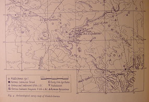
Below, an archaeological site map of "Kadesh-Barnea" and vicinity as per Professor Beno Rothenberg (1962). Scholars are divided on the location of Kadesh Barnea. Some opt for Ain el Qadeis/Qudeis (Gades/Kudeis on earlier maps) or the nearby Ain el Qudeirat (Gudeirat/Kudeirat on earlier maps). Despite repeated archaeological surveys of the areas (Qadeis and Qudeirat) archaeologists have found NO evidence of either a Late Bronze Age (1540-1200 BCE) or Iron Age I (1260-1150 BCE) occupation by Moses' Israel. Both sites appear to be no earlier than ca. 1100 BCE, each possessing a fortress of stone. As Israel is portrayed dwelling in tents which leave no occupation evidence, this "absence of evidence" is thus accounted for by some scholars.
I understand that Ain el Qudeirat is Hazar-Addar, NOT Kadesh Barnea. I understand that Ain el Qusaima is Azmon, rendered in the Targum as Qesam (Nu 34:4-5) and that Israel's presence in this area is attested by two nearby Iron Age II (11th-10th century BCE) fortresses of stone. I understand the river of Egypt ("Egypt" in Hebrew is Mitzraim, Arabic Misr, 8th century BCE Neo-Assyrian Musri) is Wadi el Arish, which takes its name from Gebel Musraq, west of El Muweilah (not on this map) because Wadi Muweilah, which is a "headwater" of Wadi el Arish, encircles the mount, turning north to join Wadi el Arish. So, the "river of Egypt" Wadi Muweilah which is a headwater of Wadi el Arish, takes its name from headwaters near Gebel Musraq.
(cf. p.34 "Archaeological survey map of Kadesh-barnea." Beno Rothenberg, et al. God's Wilderness, Discoveries in Sinai. New York & Toronto. Thomas Nelson & Sons. 1962)
I understand that Kadesh-barnea has not yet been located and have proposed that it is somewhere near modern Israeli Sede Boqer, some 50 kilometers (30 miles) ENE of Ain el Qadeis and Ain el Qudeirat. Please click here for the arguments and maps.