Dilmun, the Sumerian "Paradise," is not Bahrain or Qurnah, its Tell al Lahm East of Eridu?
02 January 2004 (Revisions through 07 August 2010)
Please click here for Dilmun possibly being Umm Daleimin by Qurnah on the Shatt al Arab River in Iraq
Please click here for my latest research which supercedes this article on why Dilmun as of 2008 has not been successfully identified yet.
Cline (2007), an Associate Professor at George Washington University, favors the area about Qurnah as being possibly the site of the Garden of Eden citing earlier research by the late Professor Ephraim A. Speiser (1959) of the University of Pennsylvania at Philadephia:
"I would follow Speiser and suggest that the Garden of Eden, if it existed, is most likely to have been located somewhere in the region of Mesopotamia and the Fertile Crescent, perhaps even near the site of Querna..."
(p. 14. "The Garden of Eden." Eric H. Cline. From Eden to Exile, Unraveling Mysteries of the Bible. Washington, D.C. National Geographic. 2007)
Another scholar favoring Dilmun to be in the marshland area of Qurna, north of Basra, is Dr. Theresa Howard-Carter, Ph.D. (1981):
"However, because no objects from Mesopotamia found in either Bahrain or Failaka can be dated earlier than 2200 B.C., it is impossible that Dilmun was located there before that time. Thus, as I have attempted to demonstrate here, the earliest Dilmun is most likely to have been located in the region of Qurna."
(p. 223. Theresa Howard-Carter. "The Tangible Evidence for the Earliest Dilmun." Journal of Cuneiform Studies. Vol. 33. No. 3/4 (July-October 1981). pp. 210-223)
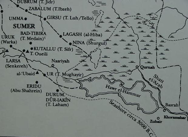
Below, a map of lower Mesopotamia showing the mouths of Euphrates and Tigris (The Greek word Tigris, which is from Persian Tigra, is the biblical Hiddekel, Arabic Diglat) rivers joining each other at Qurnah, where some Arab legends have the Garden of Eden located at.
In ancient myths Enki lived at Eridu on the edge of the marshlands and enjoyed punting his boat amongst the swamp reeds of lower Mesopotamia. He also lived at Dilmun with his wife Ninhursag. Some scholars locate Dilmun "at the mouth of the rivers" whence the Mesopotamian Flood survivor, Utnapishtim and wife (Noah and Wife of the Bible) was placed, enjoying immortality with the island of Failaka where the Shatt al Arab enters the Persian Gulf
(cf. for the map, Georges Roux. Ancient Iraq. London. Penguin Books. [1964] 1992). Ur of the Chaldees (Tell el Mughayir) where Terah and Abraham lived is just north of Eridu, the principal shrine of the god of wisdom and freshwaters called Enki or Ea. It was Enki/Ea who warned the Mesopotamian Noah to build an Ark to avoid the Flood being sent by the gods to destroy the world. In another myth Enki/Ea also confounded the one language of mankind into a babel of many tongues. He also gave Adapa personifying mankind in the Adapa and Southwind myth, great wisdom but denied him immortality as in the Adam and Eve myth. Uruk is biblical Erech (Ge 10:10) the home of Gilgamesh.
The problem in identifying Dilmun, also rendered Tilmun by some scholars with Qurnah is that I am unaware of any ancient settlement from the 4th through 1st millenniums B.C., when Dilmun appears in the records. Perhaps Dilmun/Tilmun is the site known today as Tell al Laham, 20 miles east of Eridu? (cf. above Roux's map where the site is identified as Durum, Dur-Iakin, Arabic T. Laham). However, Roaf identifies Tell al Lahm with a location called Kisiga (cf. pp. 199 & 231. Michael Roaf. Cultural Atlas of Mesopotamia and the Ancient Near East. New York. Facts on File. 1990).
Tell al Laham has 3rd millennium B.C. Sumerian burials and remains of an occupation from the 1st millennium B.C. In antiquity it would have lain in the midst of a great inland "sea" formed by the discharge of the Euphrates river and its various ancient channels or branches, said "sea" today having receded via thousands of years of silting-up to the present day Hawr al Hammar Lagoon. Ancient Sumerian texts mention Eridu as being "at the edge of the sea," and Tell al Lahm lies 20 miles east of Eridu, which would have placed it in antiquity in the midst of this sea. Hymns to Enki mention his seducing several maiden goddesses in Dilmun which is described as being in a "marshland setting" and praised for its "fish-filled lagoons and date palms." Dilmun is today identified with the island Of Bahrain (Bahrein) in the Arab Gulf (Persian Gulf) but it is not a marshland, nor does it have fish-filled lagoons or a river. In the Enki hymns he espies several maidens near a river's bank in Dilmun, gets into his boat, glides down "a river" and acosts them at the river's bank, in the marshes. Another problem in identifying Dilmun with Bahrain is that it was not settled until circa 2200 B.C. according to archaeological findings, yet Dilmun appears in Sumerian records from as early as 3300 B.C. (Uruk) to 2300 B.C. (Tello and Lagash). In other words for almost 1000 years, 3200-2300 B.C. there is no settlement at Bahrain for Sumer to trade with if Bahrain is Dilmun! Please click here for more details.
As regards "the Garden of Eden being Dilmun," further research on my part into Mesopotamian myths regarding the creation of man, reveal he is portrayed as being _created in several different locations_, Eridu (by Enki/Ea), Nippur (by Enlil/Ellil), Babylon (by Marduk/Merodach) and the steppe or flood-plains of Lower Mesopotamia near Uruk by the goddess Aruru (Enkidu of the Epic of Gilgamesh). The later location has him a NAKED savage wandering edin (Sumerian for steppe or plain) with wild animals, eating grass and lapping water like a beast. The gods take pity on man and bring him to their cities to serve them, teaching him the arts of civilization, he will tend and till their gardens next to their cities which they planted for themselves before man's creation (cf. the so-called "Eridu Genesis myth" for the details). Man is taught it is wrong to be naked like a savage animal, he must wear clothes like a god. He is shown how to grow food in irrigated gardens created by the gods for their self-nourishment (as the gods live on the earth in cities they have built in Sumer) and how to weave cloth garments to cover his nakedness. The Mesopotamian myths DO NOT PORTRAY man as being "made" and placed in Dilmun to work a god's garden. Why then, do so many scholars have Dilmun as the Mesopotamian "equivalent" of the Garden of Eden or "paradise"? The answer: Dilmun is portrayed as an "idyllic" place. Two myths exist about Dilmun: (1) The god Enki visits Dilmun and eats of the goddesss Ninhursag's plants without her permission in order "to know" them, she curses him with death. Eventually she is persuaded to change her mind. When Enki complains of his rib hurting from her earlier curse she makes a goddess called Nin-ti "lady of the rib" to heal his rib. Some scholars suspect this motif has been recast as Eve being made of Adam's rib. (2) The Mesopotamian equivalent of the Bible's Noah called variously Ziusudra, Atrahasis or Utnapishtim and his wife after the Flood is settled in Dilmun and given immortality. They will not have to toil for their food like the rest of mankind in the gods' city-gardens of Akkad and Sumer. This motif suggests for some scholars Adam and Eve in the Garden of Eden living an "idyllic" life having access to the the Tree of Life bestowing immortality.
As noted above, there are several pre-biblical Edenic prototypes, Dilmun, and three locations where man is made to be an agricultural servant of the gods, working in their city-gardens: Eridu, Nippur and Babylon, all of which are located in edin-the-floodplain between the Tigris and Euphrates rivers. In the 4th through 2nd milleniums B.C. "the mouth of the rivers" (the Euphrates and Tigris) where Ziusudra was placed in Dilmun, was near Eridu and Ur _not_ Qurnah. Thus Dilmun should lie east of Eridu and Ur at Tell al Lahm. Please click here for maps showing the mouths of the Tigris and Euphrates rivers as being near Eridu and Ur during the 4th-2nd millenniums B.C.
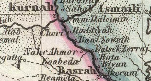
Below, a map (1860) showing a village (?) called Umm Daleimin east of Kurnah (Qurnah) and east of the mouths of the Tigris and Euphrates rivers. The Gilgamesh Epic mentions Dilmun being "at the mouth of the rivers" assumed by some to be the mouth of the Tigris and Euphrates. Is Umm Daleimin Dilmun? (Map titled: "Neueste Specialkarte von Persien." This map is on page 106 of an atlas titled: Grosser Hand-Atlas uber alle Theile der Erde in 170 Karten. Herausgegeben von J. Meyer. Hildburghausen Verlag des Bibliographischen Instituts. 1860). Please click here to access this map at the David Rumsey Historical Maps Archive). Please click here for more info on Umm Daleimin as possibly being Dilmun.
Professor Potts has recently challenged (1997) the commonly encountered scholarly perception that a "vast sea" once extended from near Ur and Eridu to the Persian Gulf in the 6th-2nd millenniums B.C. He understands that several ancient sites with traces of _irrigated fields_ found near the Hawr al Hammar Lagoon existed in the 2nd millennium B.C. and that they would have been "underwater" had such a vast sea actually existed.
He argues that these sites were strung-out in a line paralleling the Euphrates river south of the lagoon (today the Euphrates is north of the Lagoon). If he is right, then this may explain the "mystery" of Dilmun being sited near a "river" in a marshland environment. In one myth Enki is portrayed as espying maidens standing on the bank of a river in the midst of the marshlands. When he attempts sex, one maid cries out "no man take me in the marshes." Over time a succession of maidens appear at the river's bank and are accosted by Enki, who is said to glide down a river through the marshes to the bank which is described as being at Dilmun! The Euphrates presence in the marshlands east of Ur and Eridu, if rightly argued by Potts, would seem to align "Dilmun's river" in a marsh environment with any of the 2d millennium B.C. sites south of the present-day Hawr al-Hammar Lagoon. One of these sites is Tel al-Lahm, which is shown as being connected to the Euphrates via the Id-Nun canal which begins at Ur (cf. map figure 1.12. p. 28. D.T. Potts. Mesopotamian Civilization: The Material Foundations. Ithaca, New York. Cornell University Press. 1997). Potts (map figure 1.17, p. 37) shows the boundary of lands inundated by the Tigris and Euphrates rivers and this line passes to the south of Tell al-Lahm, so this site lies within the so-called "Sealands," the marshes and lagoons east of Ur and Eridu. The presence of irrigated fields at some of the sites south of the Hawr al-Hammar Lagoon reveals that apparently there existed sizable patches of land near these sites, they were not simply tiny islands in the midst of the marshes. In fact Potts has argued that the Hawr al-Hammar may be a recent phenomenon, coming into existence about 1870 (cf. pp. 36-41).
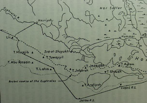
The below map by G. Roux (1960) shows pre-Islamic archaeological sites (2d millennium B.C.) in the vicinity of the Hor al-Hammar Lagoon from the vicinity of Ur to Basra. Dilmun might be one of these sites?
Potts (1997) on Georges Roux's discoveries (1960) near the Hor al-Hammar Lagoon:
"In cuneiform sources southernmost Mesopotamia was known as mat tamti(m) (Sumerian KUR A.AB.BA), the 'Sealand'...While B. Meissner could claim in 1920 that the lack of mounds in this region made it certain that it had been under water (Meissner 1920:4), G. Roux's survey of the Hor al-Hammar (fig. 1.17) showed that this was purely the result of insufficient exploration (Roux 1960:30), for there is in fact a string of mounds 'extending in an almost straight line from Tell Lahm to a point 23 miles north of Basrah' which, Roux suggests 'provides a strong argument against the classical theory according to which the whole of this region was under sea-water from prehistoric times to the dawn of the Christian era' (Roux 1960:30). The existence of sites such as Tells Kirbasi, al-Lahm, Aqram and Abu Salabikh in the area of the modern Hor al-Hammar underscores the fact that, from at least the early second millennium B.C. onwards, this was a populated area which, while it may have been marshy, was certainly not submerged beneath the Gulf. Rising no more than 2 meters above the water line, Tell Kirbasi is today periodically surrounded by water, yet it is difficult to imagine that a site like this was located on an island in the Kassite period, for there is little reason to suppose that if this were the case, Tell Kirbasi or indeed the Sealand generally would have been cited as a source of cattle and cereals. Thus, de Morgan's suggested shoreline in the time of Sennacherib would place under water sites such as Tell al-Lahm which we now know were occupied during the Neo-Assyrian period! The discovery of a cylinder of Nabonidus (555-539 B.C.) at Tell al-Lahm...moreover, confirms that 150 years after Sennacherib's time, the region was most definitely not submerged, and indeed Sanlaville's sea-level curve shows that sea-levels throughout the second millennium B.C. were only marginally higher (less than 1 meter) than they are today, while from the Neo-Assyrian through the latter part of the Parthian era, they were, contrary to de Morgan's belief, significantly lower than modern levels.
That is not to say, however, that the entire area of southernmost Mesopotamia was dry land, or that references to 'the sea' in Sennacherib's account or in texts relating to Ur and Eridu do not refer to some inland body or bodies of water which actually existed...more recently Adams has suggested, 'We may have to deal in in the past, as to a lesser extent we still do today, not with a well-defined shoreline but with a progression of swamps and more and more open, more brackish or saline lagoons' (Adams 1981:16). Nevertheless, this does not necessarily mean that the Hor al-Hammar itself existed when the sites found by Roux were inhabitated. As Roux himself remarked, the existence of relict canals near Tell Abu Salabikh and a well at Tell Aqram suggest that this region was once cultivated, as indeed the Kassite cuneiform sources cited above confirm, and drier than it is today." (pp. 37-38. Potts)
"Finally, had the Gulf actually reached the area of Ur, Eridu or Tello, one must ask whether these sites could have then existed. W. Nutzel has noted that the tidal pattern in the northern Gulf affects the waters of the Shatt al-Arab in that salt-waters enters it at least as far as Abdul Khasib, circa 10 kilometers east of Basra. The interchange of salt and sweet water would have made irrigation from such water impossible, for none of the staple cereals grown in antiquity would have been able to tolerate water with such a high salt content. Therefore, settlements must always have been situated outside the zone affected by such an interchange. The very existence of sites like Ur, or for that matter, the mounds discussed above in the Hor al-Hammar district, Nutzel argues, precludes the possibility that salt-water was present in close proximity to them (Nutzel 1980:98-9)."
(p. 39. D. T. Potts. Mesopotamian Civilization: The Material Foundations. Ithaca, New York. Cornell University Press. 1997)
For the below map cf. p. 37 map titled "The Hor-Al-Hammar." figure 1.17 Archaeological sites in the Hor al-Hammar (after Roux 1960: Map 1). D.T. Potts. 1997. Mesopotamian Civilization: The Material Foundations. Ithaca, New York. Cornell University Press.
Pre-Islamic sites are marked by a black pyramid symbol whereas Islamic sites have an "inverted" or "upside-down" pyramid and modern locations are maked by a small circle. The dotted line across the bottom edge of the map marks the boundary of where the alluvium ends (lands flooded by the Euphrates and Tigris) and the high desert not subject to flooding begins. Note that Tell al-Lahm which I have argued might be Dilmun lies within the alluvium. It is possible that Dilmun could be another site in this area such as perhaps Tells Murajib, Abu Rosain, Tuwayyil, Jabarah, Jedeidah, Aqram, or Abu Salabikh. It would need to possess evidence of a 4th-1st millennium B.C. occupation as Dilmun appears in Lower Mesopotamian records of this period of time. Tell al-Lahm and Jedeidah are documented for Early Dynastic through Ur III occupation according to Potts (2900-2000 B.C.). In antiquity Ur and Eridu were described at near the shore of a sea suggesting the Euphrates' mouth was near these two sites. To the degree Dilmun is at or near the "mouth of the rivers" in Sumerian myths about Ziusudra of Shuruppak, Dilmun might be one of the the below settlements in this area east of Ur and Eridu. Enki of Eridu in his boat, glided downstream to seduce Dimun's maidens who stood at a riverbank and the Euphrates on the below map does pass through the marshes, the maidens crying out they did not want to be taken (raped) in the marshlands by him.