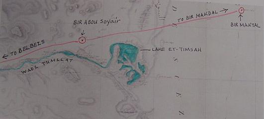
The Wilderness of Shur/Etham (Ex 15:22; Nu 33:8) Bir Abu Suwayr, Wadi Tumilat, and Lake Et-Timsah.
23 April 2010 (Revisions through 16 December 2020)
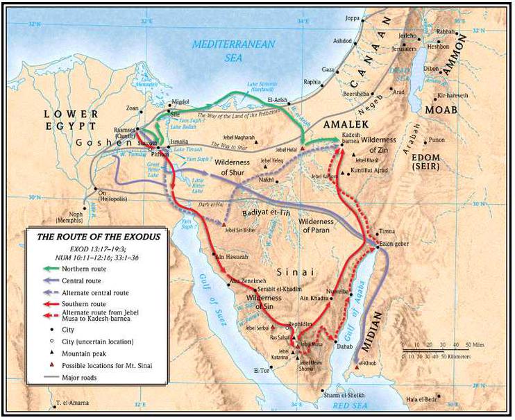
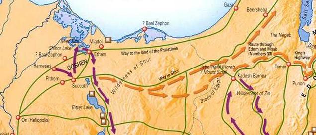
Below, various maps showing "the way to Shur" from Hebron and Beersheba crossing the Sinai and ending in the vicinity of Lake Timsah and the modern city of Ismailia founded circa 1869 at the time of the Suez Canal's dredging.
The Greek historian Herodotus (circa 425 BC) asked Egyptian priests: "What lands are Egypt?" They replied that "Egypt was the land covered in the flood waters of the Nile." Herodotus summed this up nicely by declaring "Egypt is the gift of the Nile."
Maps from the 1800s-1860s, before the Suez Canal was constructed, reveal that the annual Nile inundation reached and filled Lake Timsah. Thus Wadi Tumilat through which the flood waters flowed to fill Lake Timsah would be regarded to be a part of Egypt for the priests.
Israel camps at a location called Etham which is described as being "at the edge of the wilderness" (Ex 13:20; Nu 33:5). This suggests for me that Etham is probably either Wadi Tumilat or Lake Et-Timsah, also rendered at-Timsah, et-Temsah, an Arabic word meaning "crocodile." Crocodile's existed in the Nile in antiquity and via the Nile's annual flood waters could wind up in Lake Timsah, "the lake of the crocodile."
If I am correct in proposing that Tumilat or Timsah is Etham and part of Egypt, then the wilderness of Etham is probably the Isthmus of Suez east of the lake. Archaeologists found at Tell el-Maskhuttah in Wadi Tumilat a silver bowl dated circa the 5th century BC dedicated to the Arab goddess ilat, a feminine form of ila "god," perhaps Wadi Tumilat is a combining of two deities' names: Tum or Atum an Egyptian sun-god who's Ramesside statues were found in Wadi Tumilat and the 5th century BC Arabic goddess ilat?
I have proposed that Marah, the Greek Septuagint bible's Merrah, is the Bitter Lakes called Murra or Murrat in Arabic. Thus the "wilderness of Etham, for me, extends from the vicinity east of Lake Et-Timsah to the Bitter Lakes.
The Bible notes a track which begins in the Negeb south of Judah extending to a location called "Shur which is before Egypt." I note that the various below maps show this track as extending to the vicinity of Lake Et-Timsah.
Other Bible verses suggest that the wilderness of Etham was also called the wilderness of Shur (compare Ex 15:22 with Nu 33:8), suggesting for me that Shur and Etham are alternate names for the same area. Having proposed that Etham is Wadi Tumilat or Lake Et-Timsah I have accordingly sought a location in this area whose toponym in Arabic resembles somewhat Shur, Hebrew: shuwr. I find it at a location called Bir Abu Suwayr on the north side of Wadi Tumilat, just NW of Lake Et-Timsah. I note that the caravan track called the Darb el Shur (see p. ix, C. Leonard Wooley and T. E. Lawrence. The Wilderness of Zin. 1915) beginning at Beersheba passes the northside of Lake Timsah and goes on to Bir Abu Suwayr and the Egyptian Delta. Thus for me, shuwr is suwayr and Etham is either Lake Et-Timsah or wadi Et-Tumilat and "the wilderness" of Shur/Etham is the Isthmus of Suez east of Lake Timsah ending in the vicinity of the Bitter Lakes (Arabic murrat, meaning "bitter" whose double "r's" recall the Septuagint Bible's Greek rendering of Hebrew Marah as Merrah). The Aramaic Peshitta renders Marah as MORATH, which seems to me, to be preserved in modern Arabic's Murrat (see p. 83, Exodus 15:23, "And when they came to Morath, they could not drink the waters of Morath, for they were bitter; therefore the name of the place was called Morath." George M. Lamsa's Translation From the Aramaic of the Peshitta. Holy Bible From the Ancient Eastern Text. Harper and Row, San Francisco. 1968. Original copyright 1933, A.J. Holman Co.)
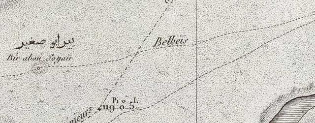
Below, a map published at Paris in 1826 based on a cartographic survey of 1796-1798 by Napoleon Bonoparte's French Army Corps of Engineers showing that the track passing to the north of Lake Timsah (C. L. F. Panckoucke. Paris. 1826. Scale: 1:100,000. "Canal de Suez") is in fact the same "way to Shur" on the above bible atlas maps. Abu Suwayr is rendered Bir Abou Soyair. Bir means "well," so Abu Suwayr was not only directly on the Way to Shur, its well made it an important stop for caravans between Judah and the Egyptian Delta. The French map calls this track to the way to Belbeis (in the Delta) from Bir Maktal. Suwayr does "lie before Egypt" as described in the Bible
(1 Samuel 15:7). Soyair/Suwayr does not receive the Nile's water so it is not a part of Egypt, it lies in the wilderness north of Wadi Tumilat. The Wilderness of Shur is an apt description of the arid land not only about Abu Suwayr but to its east, the Isthmus of Suez. Apparently the arid wilderness east of Tumilat/Timsah was called the wilderness of Etham. Thus we have at last the reason why the Bible called this area by two different names. Please click here to access this map at the David Rumsey Historical Maps Archive. I have noticed that Arabic preserves Beer Sheba as Bir es Seba, without the "h," in Egypt, Arabic preserves Seba as Saba (as in Saba Biar, "Seven Wells" in wadi Tumilat), again, without an "h" so perhaps Arabic preserves Shur, Hebrew shuwr as suwr, or Suweir, as Bir Abu Suwayr is called today?
Below, close-ups of the above map published in 1826 but surveyed in 1796-1798 showing Bir Abou Soyair (Abu Suwayr) on the track going to Belbeis in the Delta from Bir Makdal ENE of Timsah. To the viewer's lower right corner is a portion of Lake Timsah.
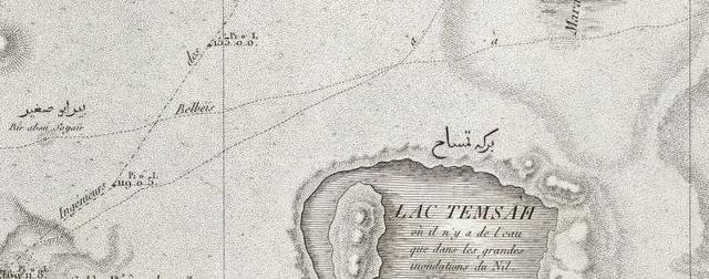
The French inscription on Lake et-Timsah (Lac Temsah) states that the lake received its water at the time of the annual flood or great inundation (French: "grande inundations du Nil"). This suggests to me that most of the year Timsah evaporated away into a stagnant marsh with a few crocodiles and marsh reeds and grasses deposited in its bed by the annual inundations from the Nile.
Professor Hoffmeier (2005) on Etham and Shur being near Lake Timsah (emphasis mine):
"The proximity of Etham to Egypt is undeniable, as it was a a toponym encountered prior to reaching yam suph, and was reported to be "on the edge of the wilderness" (Exod. 13:20; Num 33:6). The fact that the itinerary included Etham both before and after the crossing of the sea shows that a circuitous route was taken, which brought the Israelites back to the general area of Succoth and Etham (figure 1). In other words, when Israel turned back at Etham (Exod. 13:20, 14:2) they headed northward away from the Lake Timsah region where they encountered yam suph, that is, the Ballah Lakes, according to our reconstruction...Once they crossed it from its northern side, the Israelites would have traveled south, which would allow them to once again be in the wilderness of Etham. This reconstruction, as it turns out, is precisely like that of the Oxford Bible Atlas (2nd edition) and the revised Macmillan Bible Atlas. The reference to Shur in Exodus 15:22 reinforces this interpretation because of the consensus opinion that it lies in the vicinity of Lake Timsah, where the way to Shur terminated. Thus the reference to Shur and Etham place the Israelites in approximately the same place, that is, east of the lakes of the Isthmus of Suez, evidently traveling in a southerly direction."
(p. 161. "Wilderness of Shur/Etham." James K. Hoffmeier. Ancient Israel in Sinai, the Evidence for the Authenticity of the Wilderness Tradition. Oxford & New York. Oxford University Press. 2005)
Hoffmeier believes that Israel's daily rate of travel was approximately 20 miles a day, the rate of a travel of a camel caravan, which varies from 16-23 miles a day. He has Israel crossing the Red Sea or Yam Suph at the Ballah Lakes north of Lake Timsah. He locates the wilderness of Etham/Shur near Lake Timsah at Wadi Tumilat's east end. He locates Marah at Bir el-Mura in agreement with Professor Menashe Har-El of Tel Aviv University (1968). Israel's 3 days in the wilderness of Shur/Etham is for Hoffmeier a distance of 60 miles (roughly 20 miles a day) from Lake Ballah to Bir el-Mura east of the port of Suez (Bir el-Mura is 7 miles north of 'Ayun Musa).
Hoffmeier (2005) on the Red Sea crossing at Lake Ballah and Marah being Bir el-Mura east of the port of Suez:
"...a connection between the site named in Exodus 15:23 and the present day Bir el-Mura is certainly plausible, and it would fit within the distance of a three day's journey or approximately ninety-six kilometers/sixty miles from our proposed crossing point on the south side of the Balah Lake (figure 1)."
(p. 162. "Marah and Elim." James K. Hoffmeier. Ancient Israel in Sinai, the Evidence for the Authenticity of the Wilderness Tradition. Oxford & New York. Oxford University Press. 2005)
Hoffmeier on how many miles can be covered in a day's journey by camel or donkey caravans (16-23 miles):
"Travel in the Bible and in other Near Eastern texts is measured in terms of the number of days of travel required to cover the distance...Nineteeth-century explorers who traveled typically on camels, in the desert terrain of Sinai and adjacent territories, attempted to determine the distance one could travel in a day. One such investigator, H. Clay Trumbull, calculated that fifteen to eighteen miles (twenty-four to twenty-nine kilometers) approximates the distance. A more recent study based on texts from across the ancient Near East from the second and first millenniums was made by the historical geographer Barry Beitzel, who makes the following observation: "The evidence is generally uniform and mutually corroborating that one day's journey in the ancient world incorporated between 17 and 23 miles" (twenty-seven to thirty-seven kilometers)...An early second-millennium text from Mari, for instance, suggests that a caravan could move around twenty-two miles (thirty-five kilometers) per day in desert environs. This figure accords well with ethnographic evidence gathered from camel and donkey caravans, which travel between sixteen and twenty-three miles (about twenty-six to thirty-seven kilometers) per day."
(pp. 119-120. "The Wilderness Itineraries." James K. Hoffmeier. Ancient Israel in Sinai, the Evidence for the Authenticity of the Wilderness Tradition. Oxford & New York. Oxford University Press. 2005)
Three days in the wilderness of Etham/Shur extending from the crossing of Yam Suph (the Red Sea) to Marah would equate to either 48 or 69 miles at a rate of either 16 or 23 miles a day. One day's travel from Marah to Elim would be either 16 or 23 miles. Hoffmeier has Israel crossing Yam Suph at Lake Ballah and Marah at Bir el-Mura 7 miles north of Ayun Musa; he posits a distance of roughly 60 miles from Lake Ballah to Bir el Mura which upon being divided into 3 days in the wilderness of Shur/Etham has Israel's daily rate of travel at 20 miles a day.
Conclusions:
The Bible's statement that it took Israel 3 days to cross the Wilderness of Shur/Etham (Ex 15:22 & Nu 33:8) has been explained as being the same general location, the Isthmus of Suez, east of Bir Abu Suwayr (biblical Shur) and Wadi Et-Tumilat (biblical Etham), ending at the Bitter Lakes (Arabic: Murrat), biblical Marah, the Greek Septuaginta's Merrah. The Bible distinguishes between a location called Etham "at the edge of the wilderness," then a turning to Yam Suph, and after crossing Yam Suph, Israel is "in" the wilderness of Etham, not in Etham, but in the wilderness adjacent to Etham. This distinction, suggests for me Etham is probably either Wadi Et-Tumilat or Lake Et-Timsah.
The "way to Shur" (Hebrew: shuwr) from Beersheba on various bible maps passes to the north side of Lake Timsah and the Napoleonic map survey of 1796-1798 shows this track, north of Lake Et-Timsah, to pass by Bir Abou Soyair (Suwayr/Suweir). The caravans from Judah and Jerusalem to the Delta would probably stop at Suwayr for water. Suwayr is not a part of Egypt, it does not receive the Nile's waters. It is in the wilderness near Etham (Wadi Tumilat and/or Lake Et-Timsah?). It is "before Egypt, or east of Egypt" because the track after leaving Suwayr continues on to Belbeis in the Egyptian Delta as revealed on the Napoleonic map.
Etham "at the edge of the wilderness" (Ex 13:20) is in Egypt as Wadi Tumilat and Lake Et-Timsah receive the Nile's water via the annual inundations as noted on the Napoleonic map surveyed in 1796-1798, published 1826 at Paris. So the Bible is giving us two reference points for the Wilderness of Shur/Etham:
(1) A reference point outside of Egypt, in the arid wilderness: Bir Abu Suwayr on the great caravan route from Belbeis in the Delta to Beersheba in the Negeb.
(2) A reference point in Egypt: Etham at the "edge of the wilderness": Wadi Tumilat and or Lake Et-Timsah which receive the Nile's waters and thus are "a part of Egypt" according the Egyptian priests Herodotus consulted. Thus, the reason why the Bible has Israel in the Wilderness of Shur and Etham is because these two areas are side by side with each other or "cheek by jowl." Caravaneers would not be upset if the area was called the wilderness of Shur or the wilderness of Etham.
For 200 years, scholars, have in error, thought Shur was a "wall" of some sort, envisioning a system of ancient Egyptian forts or posts east of Egypt, barring access to the Delta by nomads. If I am correct, Shur is not a "wall," its a "well," Bir Abu Suwayr on the caravan route from Bilbeis in the Delta, thence to Beersheba in the Negeb!
Different spellings exist on various maps for Bir Abu Suweir, such as Abu Suwayr, Bir as Suwayr, Bir el-Suweir, Bir as-Suwayer, Bir es-Suweir, Soyer, Bir Abu Souer, and Bir Abou Suweirah. Today (2020) it is the site of an Egyptian Military Air Base with jet fighters.
As far as I am aware, I am the only individual identifying Shur (Hebrew Shuwr, Septuaginta Greek Sour) with the area of the 13 lakes at Bir Abu Suweir/Souer. My identification was made on the basis of my curiosity. I thought to myself, "IF the western terminus of the Darb el Shur is in the vicinity of lake Et-Timsah, as shown on maps in numerous Bible Atlases for the past 100 years, maybe, just maybe, somewhere in the vicinity of this western terminus, near the north side of Lake Et-Timsah, there is a site whose name resembles, somewhat, Shur (Hebrew Shuwr)? I noted that the Darb el Shur is shown on bible maps as ending just north of Lake Et-Timsah, and it was here, just west-north-west of the Lake Et-Timsah, at the western terminus of the Darb el Shur, that I found the 13 lakes of Bir Abu Suweir, just where one would expect Shur to be! I noted that Beersheba is rendered in Arabic as Bir Seba, the H not being preserved, and perhaps Arabic did not preserve the H in Shur? Thus Suweir with a missing H would be SHUWEIR, recalling Hebrew SHUWR. The locating of Shur at Suweir unlocks the mystery of where Yam Suph is, as, after crossing Yam Suph, Israel is in the wilderness of Shur, alternately called the wilderness of Etham. This suggests for me that Yam Suph (the Red Sea) is north of the western terminus of the Darb el Shur, which passes to the north of Lake Et-Timsah.
Shur, shuwr, 7793, a region of the desert, Shur (p. 114. Hebrew and Chaldee Dictionary. James Strong. Strong's Exhaustive Concordance, Complete and Unabridged, Compact Edition with Dictionaries of Hebrew and Greek Words. Word Books. Waco, Texas, 1977, paperback edition)
Please click here for the location of the Red Sea crossing which preceded 3 days in the Wilderness of Etham/Shur.
Please click here for the location of Marah the Septuaginta Bible's Merrah in Greek; Morath of the Peshitta Bible, in Aramaic, and Arabic Buheirat el Murrat, the "Bitter" Lakes.
Please click here for the location of Elim's 12 springs and 70 palm trees as Ayun Musa's 12 artesian springs and palm trees.
Please click here for the location of the Wilderness of Sin, either El Sanawi, Hosan abu Zenna or Ras Abu Zenimeh.
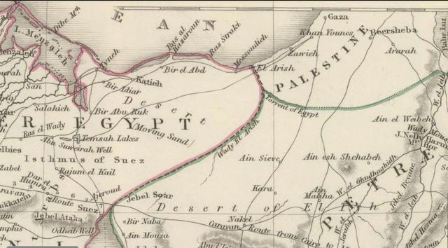
Below, a map (1848) showing an Abu Suweirah Well (Bir Abu Suweirah on other maps), my proposal for biblical Shur (Hebrew: Shuwr). Note the camel caravan tracks converging at Suweirah in 1848. Note also the tracks crossing Lake Ballah (not listed on this map), West of Bir Abu Ruk (Bir Abu Aruk on other maps), and a track crossing Lake Ballah from Salahieh, in the Delta, to Katieh. Perhaps the crossing of the Red Sea by Israel is recalling these four tracks converging on and crossing Lake Ballah? This map reveals Lake Ballah is an extension (an overflow lake) of Lake Menzaleh (see the 1848 map titled Egypt and Arabian Petraea. London. By J. W. Lowry, at the David Rumsey Historical Maps Archive on the internet)
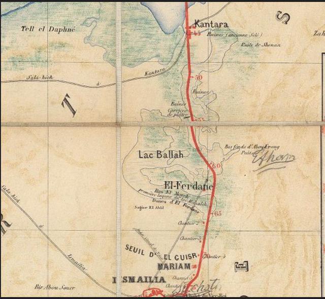
Below, a map (1869) showing that the Qantara/Kantara Land Bridge or Land Corridor separating Lake Menzaleh from Lake Ballah was apparently covered at times in flood waters from the Nile. Perhaps Israel's crossing of the Red Sea was at this seasonally flooded land corridor? We are told the sea was a wall on the right and left sides of Israel as she marched across the Red Sea (Exodus 14:21-22), this would describe the land corridor, with Lake Menzaleh being the sea/yam on the left and Lake Ballah being the sea/yam on the right side of Israel? In Hebrew, Yam can mean a sea or a lake, as for example the Dead Sea is a Lake, the Sea of Galilee is another Lake (For the map see the David Rumsey Historical Maps Archive on the internet. See the map titled Canal Maritime de Suez. Paris. Scale: 1:200,000. Author: F. P. Voisin). The light-blue-green areas show that the flooded areas could sustain marshes at times, filled with reeds and swamp grasses, deposited from the Nile, at the time of the annual great inundation, into Lakes Menzaleh and Ballah. Bir Abou Souer appears on the below map just west of Ismailia and Lake Et-Temsah.
An alternate crossing of the Red Sea might be the area labeled El Ferdane. A track is shown crossing the southernmost end of Lake Ballah. It appears on other maps as Ras el Moyeh/Ras el Ballah, and is called Birket el Karash. The below map declares this is the first lagoon encountered of Lake Menzaleh: "premiere lagune de lac Menzaleh" (Lake Ballah being an overflow extension of Lake Menzaleh). Note Bir Abou Souer (my proposal for Shur) just west of Lake Timsah and the modern port of Ismailia. I have noted that Souer does not preserve the Hebrew "h" of Shur/Shuwr. I also note that Arabic does not preserve Hebrew "h" in Beersheba, it is rendered as Bir es Seba. West of Lake Et-Timsah is Biar Saba, the "seven wells," again, Arabic does not preserve Hebrew "h" rendering "seven" as SABA, NOT SHEBA, so Souer/Suweir without the Hebrew "h" is not a strange thing to behold, in my way of thinking, that is to say Hebrew shuwr became in Arabic suwier/souer/suweirah, add the missing Hebrew "h" and we have shuweir, shouer, shuweirah.
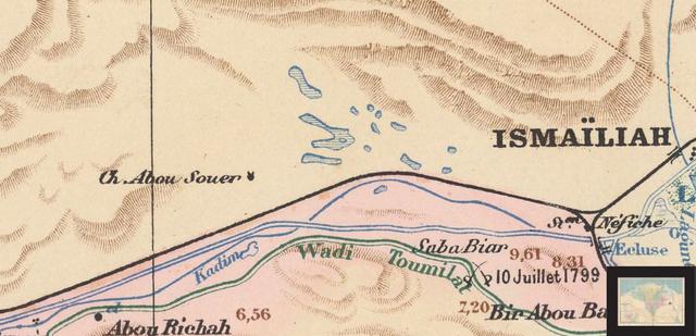
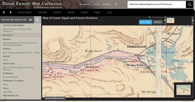
Below, a French made map showing Ch. (A French abbreviation for: Cheikh, English: Sheikh) Abou Souer, apparently a Holy Site or Tomb, marked by a black dot with horns, nearby are some 13 seasonal (Sebkah?) lakes (cf. Map Titled: Carte de la Basse-Egypte et de la Province du Fayoum, by Charles Audebeau. 1897, map scale: 1:200,000 and available at the on-line David Rumsey Map Archive). Perhaps these lakes are why Shur was such an important landmark, as in the Bible's statement: "The Way to Shur." These lakes would be an important stop for the watering of camel caravans on their way to Egypt from Beersheba. The Greek Septuaginta Bible of circa 275 BC renders SHUR as SOUR, which resembles somewhat Arabic Bir Abu SOUER (cf. Exodus 15:22 "Then Moyses ...led them into the wilderness of Sour." Pg. 62, Albert Pietersma and Benjamin G. Wright, editors. A New English Translation of the Septuagint. Oxford University Press. 2007)