Please click here for this website's most important article: Why the Bible Cannot be the Word of God.
Please click here for my latest map (21 Nov. 2009) showing the site of Israel's "crossing of the Red Sea"
in the Exodus as being at Ras el Ballah (my Baal-zephon)
Before reading any of the "below" the reader should _first_read_ my article titled "Exodus Problems" which argues that the Exodus route appearing in the Bible (Numbers 33:1-50) appears to be a figment of the imagination of a later writer circa 560 B.C. it is _not_ an eye witness account by a 16th (1512 B.C. for Catholics) or 15th century B.C. (1446 B.C. for Protestants) Moses or anyone else. Please click hereto access this very important article.I understand that the "real" route of the Exodus was, paradoxically, the very route the Bible claims was _not_ taken: "the way to the land of the Philistines" (Exodus 13:17) across the northern Sinai and skirting the south shore of the Mediterranean Sea!
Over the past 100 years the Exodus has generated an "enormous" literature. This article looks at just a "_few_" of the MORE RECENT examples of some of the "many" map proposals for the Exodus route. I have added "Critiques" noting the Archaeological evidence or lack thereof for the various proposals.
Many understand that the Exodus is a Late Bronze Age event (occurring within the timeframe of ca. 1560-1200 B.C.). One date in favor with many Conservative scholars is ca. 1446 B.C. on the basis of 1 Kings 6:1. Many Liberal scholars, however, favor a Ramesside era Exodus, ca. the late 13th or early 12th centuries B.C. (the Late Bronze-Early Iron I eras, Iron I being ca. 1230-1000 B.C.) on the basis of the mention of the store city built by Israel called Rameses, which they understand is Pi-Ramesses, built by Pharaoh Ramesses II.
Generally speaking there is no Late Bronze Age (LBA) evidence for the Sinai, Negev and Arabah, places Israel wandered in according to the Bible. There are, however, some "exceptions": Late Bronze Age (13th century B.C.) Ramesside fortresses or way-stations are documented for the N Sinai along the biblical "way to the land of the Philistines." LBA and Iron I (1560-1130 B.C.) also exists at various Egyptian-run mining camps in the SW Sinai near the Copper and Turquoise mines of Serabit el Khadim and Wadi Maghara. A Ramesside era presence (Seti I through Ramesses V, ca. 1291-1140 B.C.) is attested for the N Negev (Tell Masos and a site on Wadi Yattir near Arad being Iron I) and the Arabah (the Egyptian-run copper mines of Har Timna and Wadi Amran). A few LBA and Iron I sites exist in Edom near the juncture of Wadi el Hesa and the Dead Sea (Note: The Israeli scholar Israel Finkelstein claims some Edomite Iron II pottery is actually Iron I). Iron II is widely attested all over the Negev, Arabah and Edom. One Iron II site exists in the S Sinai at the Feiran Oasis.
Warning: To date (2004), archaeologists have failed to document a single "Israelite camp site" in the Sinai, Negeb or Arabah. Because no proposal for Mount Sinai, be it in the Sinai, the Negev, or in Arabia has produced the required Late Bronze Age _or_ Early Iron Age pottery debris, there is NO scholarly consensus on which location is the "correct" site. To get around this archaeological anomaly, some scholars have invoked "arguments from silence." That is to say, "just because we have no archaeological evidence of Israel in these areas, doesn't mean the event didn't happen or the site proposed is wrong." This then progresses to the next "argument from silence": The "rationalizing" or "explaining away" of the missing evidence: Israel was a nomadic tent dwelling nation in the Exodus and did not use pottery, only goatskins for water. So, as tents leave no evidence, and neither do waterskins, the "absence of evidence" is accounted for.
A "serious problem" in identifying Israel's encampments is that there is _no agreement_ among authorities as to the distance Israel traveled each day between camps.
Professor Hoffmeier noted that several ancient itineraries suggested that caravans consisting of either camels or donkeys could attain a daily rate of 15 to 20 miles, and he suggests that this is Israel's rate of travel in his Exodus campsite proposals. The problem? Other scholars dispute this. They argue that Bedouin nomads who make their living herding goats or sheep usually do not exceed anywhere from 6 to 10 miles a day so as to not exhaust their flocks. They argue that as Israel is portrayed leaving Egypt with flocks of goats and sheep and herds of cattle, it is impossible for her to achieve the daily rate of a camel or donkey caravan. The problem? If Israel's daily rate of travel is determined by her flocks then she could not have gone more than 6 to 10 miles each day between encampments. This is a "very serious" problem! Why? Because NO PROPOSAL from any authority (biblical scholar) can get Israel from one proposed campsite to another in one day at a rate of 6 to 10 miles a day! As proposed by Hoffmeier, the currently favored campsites are attainable if 15 to 20 miles a day is achieved. To illustrate what I mean: Gebel Musa or Ras Safsafeh near Saint Catherine's monastery is favored by some to be Mount Sinai and either Ain Qadeis or nearby Ain Qudeirat is thought to be Kadesh Barnea in the Negev. We are informed it is 11 days journey by the way to Mount Seir from Mount Horeb (Mt. Sinai) to Kadesh (De 1:2). The actual distance from Gebel Musa to Ain Qadeis as the crow flies is about 160 miles. This is possible if Israel covers 15 miles a day or 165 miles in 11 days. If her flocks of goats, sheep and herds of cattle allow only 6 to 10 miles a day it is not possible. At 6 miles a day 26 days would be needed. At 10 miles a day 16 days would be needed.
Hoffmeier, refering to Beitzel's investigations:
"This figure precisely lies between the twentyfour and thirty-two kilometers (fifteen and twenty miles) per day that was reckoned based on comparitive travel distances from ancient texts." (p. 144. James K. Hoffmeier.
Ancient Israel in Sinai, The Evidence for the Authenticity of the Wilderness Tradition. Oxford & New York. Oxford University Press. 2005. ISBN 0-515546-7)
Beitzel:
"Itinerary texts from the Mosaic period stipulate that caravans were able to cover no more than about 20-23 miles per day. With the Exodus, however, the size and the background of the group, when combined with the factors of accompanying women and children and flocks and herds (Ex 12:38; 34:3; cf. 17:2; Nu 20:19), eliminate any possibility...The average daily distance maintained by modern bedouin moving from camp to camp is about six miles." (p. 91. Barry J. Beitzel. The Moody Atlas of Bible Lands. Chicago. Moody Press. 1985, 1988. ISBN 0-8024-0438-3)
Bryant G. Wood, a trained archaeologist observes : "A large group of pastoralists moving with their possessions and animals can cover no more than 6 miles in a day, and usually less (Conder 1883: 79; cf. Beitzel 1985: 91). The limiting factor is the animals. When the Israelites left Egypt, they had "large droves of livestock, both flocks and herds (Ex 13:38)." http://abr.christiananswers.net/jebel_thoughts.html
Professor Har-El prefers a daily rate of travel for Israel of about 6 miles (10 kilometers), based on his once having been a shepherd himself. He is critiquing Shafei's 1946 proposal for the Exodus route from Rameses to Yam Suph (emphasis mine in capitals):
"Shafei's map indicates that the Israelites covered 18 km [11 miles]. on the first day of the journey, 26 km [17 miles] on the second, and 24 km. [15 miles] on the third. This view is entirely untenable for the following reasons: a) Old people, women and children could hardly progress at such a rate...b) Herds with their young cannot cover such long distances without collapsing on the way (I know this from my own experience as a shepherd); c) Such a large mass of people, weighed down by large quantities of baggage and heavily laden with posessions, could not possibly have made such rapid progress. Conder's observation that the Bedouin who move camp travel at _A MAXIMUM OF SIX MILES A DAY [10 kilometers]_ also provides support to this point of criticism. His estimate refers to small groups of Bedouin who are properly prepared for their move, in contrast to the large numbers of the Israelites who left Egypt in a hurry, without having made preparations for their journey."(p. 167. Menashe Har-El. " Criticism of Shafei's View." The Sinai Journeys, The Route of the Exodus. San Diego, Calfornia. Ridgefield Publishing Company. 1983. ISBN 0-86628-016-2 [first published in Hebrew 1968, by Am-Oved Publishing Ltd. Tel Aviv])
One individual noted (in an e-mail to me 09 Oct 2005): "Another Archaeologist, Clark Hopkins (of Yale) while directing a dig at Dura-Europas in the Syrian desert, noted that herders were moving 8-10 miles a day in areas where there was not enough pasture to satisfy the small livestock."
All this is to say, that if it is "impossible" for Israel to attain the daily rate of travel of a camel or donkey caravan because of the sheep, goats and cattle accompanying her, then ALL SCHOLARLY PROPOSALS
(including my own) ARE DOOMED TO FAILURE, as NONE present an Exodus route based on a daily rate of travel of not more than 6 to 10 miles a day between _all_ the encampments!
Bible scholars such as Burkhardt and Robinson who explored the Sinai's Exodus Route in the 19th century A.D. did so by camel with Arab guides. These camels' pace was about 2 miles an hour and a day's trek was usually about 10 hours, or roughly 20 miles a day. It is this phenomenon that apparently lies behind their proposals for various sites of the Exodus, assuming a daily rate for Israel of 20 miles. Their proposals based on this phenomenon lie behind the identity of Marah with Ain Hawara, Elim with Wadi Gharandal, Sin with the coastal plain south of Ras Abu Zenimeh, and Gebel Musa being 11 days travel _by camel_ to Ain Qadeis and Ain Qudeirat.
Because of the above "anomalies" I have the following proposals to make:
1) The encampments presented in the Exodus account are perhaps a "late fabrication" of the Iron II period (9th-6th century B.C.) and are based on a "genuine itinerary" as _achieved by camel or donkey caravans_ which perhaps traversed the southern Sinai from the Negev to Egypt. Their daily rate of travel being 15 to 23 miles a day. I note that archaeolgists found at the Feiran Oasis pottery in the southern Sinai pottery sherds from Iron II Judah of the 9th-8th century B.C. Perhaps a caravan from Judah left these shards enroute to Egypt? If so, then the Exodus route and its encampments may be based on data from such caravans.
2) If 1) is "correct" then it follows that the route of a real Exodus is _not_ recoverable, as sheep, goats and cattle could not achieve the rate of travel of a camel/donkey caravan. Professor Hoffmeier's proposal of sites for the Route of the Exodus is pretty much that of earlier scholars since the 19th century A.D. explorations by camel of various Bible scholars (Burkhardt, Robinson, etc.). To me it makes sense, a camel caravan's encampments are being preserved in the Exodus account.
3) NO SCHOLARLY PROPOSAL (myself included) for the "Route of the Exodus" -to date- is based upon a _realistic_ travel rate of goats, sheep and cattle of not more than 6 to 10 miles a day for _all_ the encampments.
4) If employing a daily rate of travel for Israel of not more than 6-10 miles a day, the "most likely route" of the Exodus _it appears to me_ would be the Arabic Darb es-Shur, identified by some with the Biblical 'Way to Shur', a track from Beersheba to Muweileh in the Negev which then crosses the N Sinai terminating at Lake Timsah and the east end of Wadi Tumilat. The problem? Not even this "much shorter route" can be reconciled with the list of encampments from Rameses to Kadesh Barnea, using a daily travel rate of 6 to 10 miles a day. One of the "problems" with this route is that after crossing Yam Suph, Israel wanders 3 days in the wilderness of Shur, then stops at Marah, then Elim, then the shore of Yam Suph AGAIN. If Yam Suph is the region embracing the Ballah Lakes, Lake Timsah, the Bitter Lakes and Gulfs of Suez and Aqaba as proposed by Professor K. A. Kitchen, then where is the SECOND Yam Suph on the Darb es-Shur?
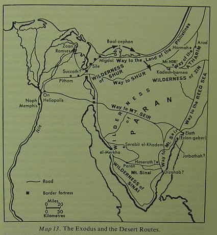
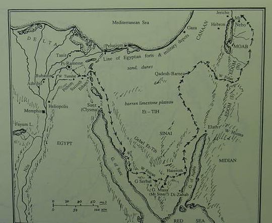
Below, the late Israeli scholar Yohanan Aharoni's Map of the Exodus, which for him, occurred at the end of the 13th or beginning of the 12th century B.C., the Ramesside period, he prefers the reign of Ramesses II for the event (p. 197. "Map 13. The Exodus and the Desert Routes." Yohanan Aharoni. The Land of the Bible, A Historical Geography. [Revised and Enlarged Edition]. Philadephia. The Westminster Press. 1962, 1967, 1979. ISBN 0-664-2466-9).
Critique: The Philistines are understood by some scholars not to have settled in Canaan until ca. 1175 B.C. when they arrived as invaders in the reign of Pharaoh Ramesses III as the "Pelest". Thus the term "the way of the land of the Philistines" suggests for some scholars an Exodus composition created no earlier than ca. 1175 B.C. Moses withstanding Pharaoh at Rameses/Zoan/Tanis (PS 78:12,43, cf. also Nu 13:22) is a problem as the site was not a pharaonic residence until ca. 1069 B.C. As late as the 1970's some scholars still thought biblical Rameses was Hyksos Avaris (Ex 12:37, Nu 33:3) and to be identified with Zoan/Tanis because it possessed Ramesside statues. Today (2004) most now associate Avaris with Tell ed Daba and Rameses with nearby Qantir because both have Ramesside pottery debris while Tanis does not. Succoth/Tell el Maskhutah has Hyksos 16th century B.C. and Saitic late 7th century B.C. debris only. Sile/Tjaru/Tell Abu Sefeh has no Egyptian New Kingdom pottery debris, only Roman debris despite the Ramesside building blocks being found. Migdol/Tel el Heir north of Sile has only Roman era pottery debris but is not fully excavated so it may yet yield New Kingdom evidence. The Paran/Feiran Oasis has Stone Age, Early Bronze II and Iron II 9th/8th century B.C. sherds from Judah. Kadesh Barnea/Ain el Qudeirat and vicinity has Stone Age, Early Bronze II, Middle Bronze I and Iron II debris (ca. 1000-587 B.C.). Hazeroth/Ain el Huderah has only Nawami burial huts of the Stone Age. Elath/Aila is Nabatean 4th century B.C. at earliest. Ezion-Geber/Tell el Kheliefeh is Iron II, 8th century B.C. at earliest. Dizahab/Dahab is Nabatean 2d Century B.C. at earliest; Arad is Early Bronze II and Iron II only. Earliest debris on the sea-facing sandbar of the Baal-Zephon/Lake Sirbonis/Bardawil Lagoon is Persian of 6th century B.C. Mt. Sinai/Gebel Musa has only Stone Age and Early Bronze II in the general area (At Sheikh Nabi Saleh in Wadi esh-Sheikh 8 kilometers or 4.5 miles ENE of Saint Catherine's Monastery). Jotbathah/Ain et Taba has only Late Roman/Byzantine remains. El Merkha on the W shore of the Sinai is a LBA Egyptian anchorage for miners working at Maghara and Serabit el Kadim.
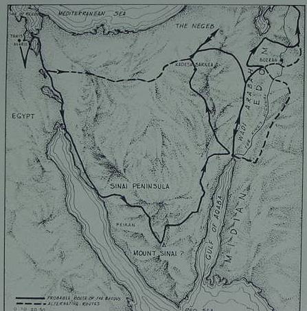
Below, Magnus Magnusson's Exodus Route Map (He seems to favor a Ramesside Exodus). The dotted line is labeled an "alternate route proposal," while the solid line is the "probable route." (p. 66. "Probable Route of the Exodus." Magnus Magnusson. Archaeology of the Bible. New York. Simon & Schuster. 1977)
Critique: His "Tanis/Avaris"/Zoan/Rameses is not a Pharaonic residence until ca. 1069 B.C. (Today Avaris is located at Tell ed Daba and Rameses at Qantir as Tanis does not have Ramesside pottery debris, only Ramesside statues). Avaris/Tell ed Daba was abandoned the mid 16th century B.C. reoccupied in 14th/13th under Pharaoh Horemhab whose cartouche appears on a lintel of the Seth temple at Tell ed Daba (he reigned ca. 1321-1293 B.C.). Kadesh Barnea/Ain el Quderat and vicinity has Stone Age, Early Bronze II, Middle Bronze I and Iron II only (ca. 1000-587 B.C.). Bozrah/Buseirah no earlier than 8th century B.C. Iron II. Mt. Sinai/Gebel Musa has only Stone Age and Early Bronze II in the general area ( At Sheikh Nabi/Nebi Saleh/Salih in Wadi esh-Sheikh, 8 kilometers/4.5 miles ENE of Saint Catherine's Monastery, are Early Bronze II copper miners' huts, corrals, and burial tumuli, they were apparently from Arad in the Negev and worked the copper mines at Wadi Reqeita/Riqita, 12 kilometers/8 miles ENE of St. Catherine's. I am _unaware_ of ANY kind of archaeological debris in the IMMEDIATE vicinity of Gebel Musa/Mt. Sinai and St. Catherine's Monastery except for the Late Roman and Byzantine eras of the 4th-7th centuries A.D.).
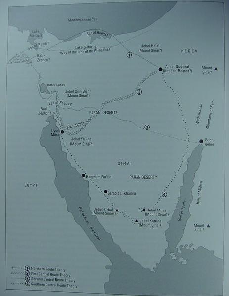
Below, Ian Wilson's Exodus Route Map, he favors a 15th century B.C. Exodus as espoused by Dr. Hans Goedicke, noting 4 different proposals:
(1) Northern Route Theory; (2) First Central Route Theory; (3) Second Central Route Theory; (4) Southern Central Route Theory. He shows several proposals for Mount Sinai: Jebel/Gebel el Halal, Jebel Sinn Bishr, Jebal Serbal, Jebel Musa, and Jebel Katrina/Catherine, the site east of Ain el Qudeirat (Kadesh-Barnea) on the below map is some unidentified mount in Edom as some texts suggest for some scholars that God dawned from Seir and Edom upon his people. Another location is in NW Saudi Arabia and the land of Midian (modern Madyan), Charles Beke in 1873 favored Har-Nur but later withdrew this identification. Currently (2004) Jebel el Lawz in Madyan has been proposed by a number of individuals: Ron Wyatt (1984), and later by Robert Cornuke, Larry Williams, David Fasold, Howard Blum and Lennart Mollert (For the below map cf. p. 154. Ian Wilson. The Exodus Enigma. London. Weidenfeld & Nicholson. 1985. ISBN 0-297-78749-7; published in the USA as Exodus, the True Story Behind the Biblical Event. San Francisco. Harper & Row. 1985)
Critique: Ramesside fortresses exist ENE of Lake Ballah/Baal-Zaphon barring entry into Egypt's eastern Delta from the N Sinai and Canaan. The Red Sea/Yam Suph Sea of Reeds/Lake Sirbonis/Baradwil Lagoon has only Persian debris at earliest on the sandbar to the north of the lagoon. The Red Sea/Yam Suph Sea of Reeds is alternately located at Lake Manzelah or the Bitter Lakes above Suez. Baal-Zaphon/Gebel Attaqa at the head of the Suez Gulf has a Ramesside fortress of Ramesses III at Clyzma (Qom Qulzoum). None of the below Mount Sinai proposals has been documented as possessing Late Bronze Age/Early Iron I debris (Note on map "errors": Jebel Sinn Bisher should be located near Wadi Suder, ESE of Uyun Musa and Jebel Ya'llaq should be west of the circled number 1 in the northern Sinai). Mount Sini/Jebel Halal has Middle Bronze I. Mount Sinai E of Kadesh-Barnea is perhaps Petra's Jebel Mahdbah whose occupation is no earlier than the Nabatean era, 4th century B.C. (identified by a Danish scholar Ditlef Nielsen in 1928). The Mount Sinai ESE of Ezion-Geber/Tell el Kheliefiyeh in NW Saudi Arabia's Madyan district might be Jebel el-Lawz as identified by Ron Wyatt in 1984 (Jebel el-Lawz has only Nabatean debris of 4th century B.C. to 2d century A.D.). Mount Sinai/Jebel Serbal's inscriptions thought to be Israelite by some scholars in the 19th century A.D. are Roman-Byzantine. Serabit el Khadim on the below map has Late Bronze and Iron Age I debris of Egyptian Miners of Turquoise and Copper. The Wadi Reqeita copper mines 12 kilometers/8 miles ENE of Saint Catherine's Monastery were apparently unexploited after Early Bronze II. Kadesh-Barnea/Ain el Qudeirat has Stone Age, Early Bronze II, Middle Bronze I and Iron II only. Ezion-Geber/Tell el Kheliefeh is 8th-5th century B.C.
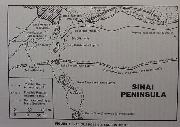
Below, William H. Stiebing Jr.'s Map of the Exodus, from the area of Egypt (He favors a Ramesside Exodus). The dotted line is Dr. Hans Goedicke's (1982) proposed Exodus route, an event he associates with the explosion of the volcanic island of Thera which he dated to ca. 1450 B.C. but now dated by others to no later than ca. 1525 B.C. (cf. pp.102- 107. Redating the Exodus and Conquest." William H. Stiebing Jr. Out of the Desert? Archaeology and the Exodus/Conquest Narratives. Amherst, New York. Prometheus Press. 1989. ISBN 1-57392-235-8).
Critique: Tanis/Zoan/San el Hagar, did not become a pharaonic residence until ca. 1069 B.C. Pithom/Tell er-Retabeh does have Ramesside pottery debris. Tell Defaneh (biblical Tahpanhes of Jeremiah 43:8-13) and Pelusium are Saitic and no earlier than the 7th century B.C. The sea-facing sandbar of Casium-Baal-Zephon/Lake Sirbonis/Bardawil Lagoon has no debris earlier than the Persian era (6th century B.C.). Migdol/Tell el Heir has not been fully excavated, Hoffmeier (1996) stated that only a Roman occupation was attested. Migdol/Sile/Tjaru/Tell abu Sefeh had no pottery debris earlier than the Roman period, despite Ramesside building blocks found at the site. Yam Suph, the Red Sea or Sea of Reeds, is variously located at Lake Menzaleh, the Ballah Lakes, the Bardawil/Sirbonis Lagoon, Lake Timsah, the Bitter Lakes, and the Gulfs of Suez and Aqabah. No chariots have been found in any of these bodies of water. Claims by Lennart Moller that a chariot wheel was found in the Gulf of Aqaba are unsubstaniated until such time as when an archaeological investigation can be done. In Christian times -the 4th/6th centries A.D.; it was claimed that chariot tracks existed in the shoals near the Roman fort of Clysma (north of the modern port of Suez) and were shown to pilgrims as proof this was where the crossing of the Red Sea occurred.
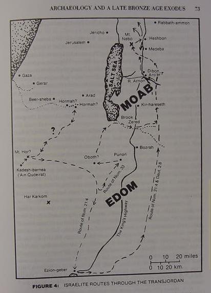
Below, William H. Stiebing Jr.'s Map of the Exodus, showing the invasion of Transjordan (cf. p. 73. William H. Stiebing Jr. Out of the Desert? Archaeology and the Exodus/Conquest Narratives. Amherst, New York. Prometheus Press. 1989. ISBN 1-57392-235-8).
Critique: No Late Bronze Age for Arad, Kadesh-Barnea/Ain el Qudeirat, Ezion Geber/Tell el Kheliefieh, Bozrah/Buseirah, Punon/Fenian, Dibon, Medeba or Heshbon/Hesban. Tel Masos has Middle Bronze II and Iron I. Most of these sites are occupied however in the Iron Age II.
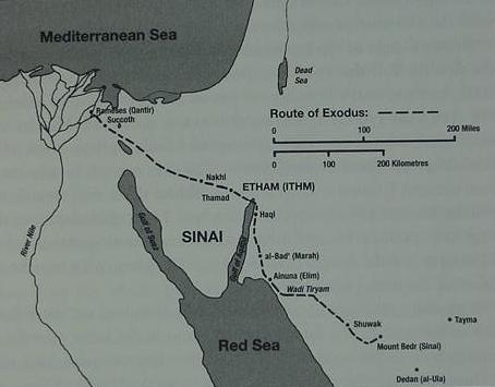
Below, Professor Colin J. Humphreys' Exodus Route Map, from Egypt to Etham, which he identifies with Arabic Wadi el-Yitm (Yutm), a mountain pass just north of the modern port of Aqaba (Aqaba not appearing on this map, but north of the port of Haql). Humphries understands Mount Sinai is a Volcano and thus identifies it with Jebel Bedr in NW Saudi Arabia north of Dedan (al- Ula) on the below map. He favors the Exodus to be a Ramesside event and that Kadesh Barnea is in the vicinity of Ain el Qudeirat and Ain el Qadeis in the Negev. He understands that the volcanic smoke plume from Bedr was the "Pillar of cloud" which lead Israel to the sacred mount. (cf. p. 329. Map titled "The Route of the Exodus to the true Mount Sinai (Mount Bedr)." Colin J. Humphreys. The Miracles of Exodus, A Scientist's Discovery of the Extraordinary Natural Causes of the Biblical Stories. HarperSanFrancisco. 2003. ISBN 0-06-051404-3)
Critique: No archaeological investigations have been done at Jebel Bedr. How does a volcanic smoke plume as Yahweh's pillar of cloud "lead" Israel westwards to Kadesh-Barnea/Ain el Qudeirat in the Negev _from_ Jebel Bedr which is ESE of Kadesh-Barnea (cf. Nu 10:11; 12:16; 13:1-3; 17-26)? Yitm/Etham has only Iron II in the general area at Tell el Kheliefeh/Ezion Geber (8th-6th century B.C.). Rameses/Qantir was founded by Seti I and son Rameses II ca. 1291-1212 B.C.; Succoth/Tell el Maskhutah has no Ramesside debris and is no earlier than Saitic era of the late 7th century ca. 610 B.C. (with the exception of a Hyksos occupation ca. 16th century B.C.). Some scholars suggest Etham was only a day's march from Succoth/Tjeku/Tell el Maskhutah (or Tell er Retabeh) in Wadi Tumilat and thus locate Etham near lake Timsah. Humphrey's Etham/Yithm near the port of Aqaba would take almost a week to reach from Egypt, traveling at 20 miles a day.
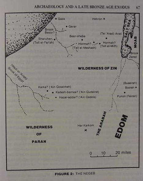
Below, William H. Stiebing Jr.'s Map of the Exodus and area of Kadesh Barnea, equated by many with Ain el-Qudeirat. Of interest, is Har Karkom marked by an "X" a site favored by Prosessor Emannuel Anati as being Mount Sinai (cf. p. 67. William H. Stiebing Jr. Out of the Desert? Archaeology and the Exodus/Conquest Narratives. Amherst, New York. Prometheus Press. 1989. ISBN 1-57392-235-8).
Critique: There is no Late Bronze or Early Iron Age I debris for Ain el Qadeis or Ain el Qudeirat, only Stone Age, Early Bronze II, Middle Bronze I and Iron II (ca. 1000-587 B.C.). Har Karkom has Stone Age and Early Bronze Age debris but no Late Bronze or Iron I. Beersheba/Tell es Saba has Stone Age and Iron II. Hormah/Tell el Meshash/Tel Masos has Middle Bronze II and Iron I. Arad has Early Bronze I & II and Iron II. Hebron/Tel Hebron has Early Bronze I,II & III, Middle Bronze II, Iron I and II (apparently either unoccupied or minimally occupied in the Late Bronze Age). Bozrah/Buseirah is no earlier than Iron II, the 8th century B.C.
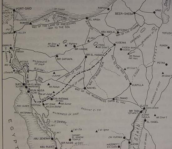
Below, Professor Menashe Har-El's Route of the Exodus Map (He favors a Ramesside Exodus). He restricts his Exodus investigation to an itinerary from Egypt to Kadesh Barnea. He understands that Mount Sinai is Jebel Sinn Bishr, ESE of Ayun Musa and that "Sinn" or "Sin" preserves the word Sinai. From there Israel marched north across the Badiet et-Tih, "wilderness of the Wandering," to Kadesh, which he identifes with Ain el Qadeis. He rejects Ain el-Qudeirat as being Kadesh because it does not fit the biblical description of being a site without water, noting its copious spring (cf. p. 357. for "Map of the Route of the Exodus." Menashe Har-El. Sinai Journeys, the Route of the Exodus. San Diego, California. Ridgefield Publishing Co. 1983 ISBN 0-86628-016-2 [first published in Hebrew by Am-Oved Publishing Limited. Tel Aviv, Israel. 1968]) Har-El also provides numerous maps for the Exodus Route by earlier scholars and critiques their site proposals.
Critique: No archaeological survey at Gebel Sinn/Sin Bisher/Bishr has been done, only a name association. I note that Sinn/Sin Bishr could just as well preserve "the wilderness of Sin" as well as "Sinai". Har-El identifies Marah with Bir el Mura/Murr which has brackish water (not archaeologically surveyed). Elim's 12 springs is identified with the palmtree oasis (Elim means Trees in Hebrew) of Ayun Musa "the wells of Moses" which has 12 springs, all of which are brackish except one (I am unaware of an archaeological survey). He has the Exodus route going up Wadi Sudr past Jebel Sinn Bishr to the et-Tih plateau, heading for Kadesh-Barnea/Ain el Qadeis, which has Stone Age, Early Bronze II, Middle Bronze I and Iron II debris in the general vicinity (ca. 1000-587 B.C.). Arad has Early Bronze II and Iron II and NO Late Bronze or Iron I. Kuseima/Quseima has Stone Age, Early Bronze, Middle Bronze and Iron II. Archaeological surveys of his southern portion of this route, south of Bir Hasana, have noted debris of the Stone Age, Early Bronze and Middle Bronze, I am unaware of any Late Bronze or Iron I being found along this route across the southern portion et-Tih (The Wadi el Arish drainage basin).
Please click here(and scroll down to the 15 Jan 2006 update) for Yam Suph's location _if_ Israel's daily rate of travel _was no more than 6 miles a day_ due to flocks of sheep accompanying her as advocated by Conder, Beitzel, Wood and Har-El. Many scholars associate Rameses, where the Exodus began, with Qantir (Pi-Rameses). Day One of the Exodus: Rameses/Qantir to Succoth, 6 miles. Day Two of the Exodus: Succoth to Etham, 6 miles. Day Three of the Exodus: "Turn back" from Etham and encamp before Yam Suph (the Red/Reed Sea). If Israel is "turning back" on herself from Etham to Yam Suph is this sea between 6 to 12 miles from Rameses/Qantir ? I have located TWO areas within 12 miles of Qantir which possess bodies of water for Yam Suph. The maps show these bodies of water to be "intermittent lakes", at times dry and other times filled with water. That is to say, ALL the "earlier" scholarly proposals for Yam Suph do not fall within the parameters of between 6 to 12 miles from Rameses/Qantir, such as Lake Bardawil in the northern Sinai, Lake Ballah, Lake Timsah, the Bitter Lakes, the Suez Gulf. The widely held notion that Succoth is a Ramesside Egyptian region called Tjeku in Wadi Tumilat and Etham is near Lake Timsah ALSO FALL OUTSIDE the parameters of sites lying no more than 12 miles from Rameses/Qantir. Of course if Israel "could exceed 6 miles a day" with flocks of sheep and goats and herds of cattle then the parameters can be expanded. To Get to Tjeku/Succoth from Qantir/Rameses in TWO DAYS, the rate of travel would have to be about 20 miles a day. Can sheep, goats and cattle _really_ be driven 20 miles a day?
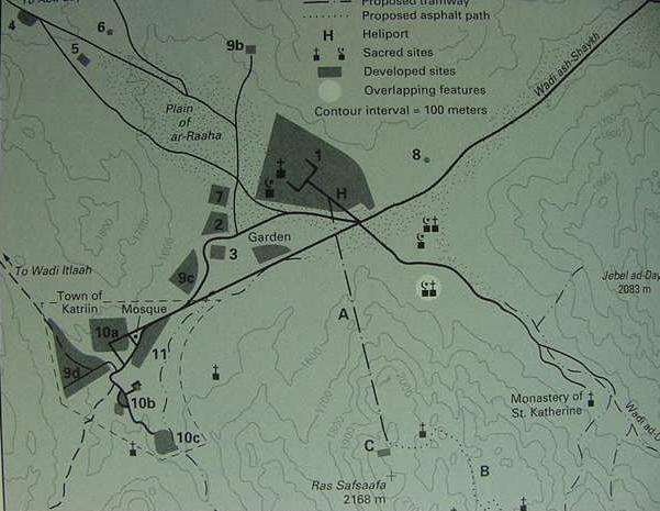
Hobbs has noted that a Neolithic (New Stoneage circa 5,500 to 4,500 B.C.) settlement was found on a slight rise abutting the south western edge of the plain of er Raha (el Raha, ar-Raaha) during excavations in 1990-1991 to create the foundations for the Daniella Tourist hotel. I wonder if perhaps as early as Neolithic times some of the nearby mountains may have been regarded as "sacred"? If Neolithic folk could dwell long enough here to build a settlement in stone, perhaps a tent-dwelling Israel could have survived here as well? The banana-shaped rise would protect the settlement being destroyed by sudden flood torrents in the wadies descending Ras esh-Safsaf and Gebel Musa during the winter rains. The Bible has Israel encamped at Mt. Sinai/Horeb for one year, which would mean she would have to contend with possible winter flooding from the wadies emptying on to the er Raha plain. It would make sense to me that the banana-shaped rise would be the "safest" area for Israel to camp upon to avoid floods which could possibly destroy the encampment and the flocks of animals she had with her.
Hobbs:
"I returned to Mount Sinai last week. I spent the first afternoon walking across the Plain of ar-Raaha, taking stock of the growth that has occurred there since my last visit in 1989...I spent the night in a two-year-old, one-hundred-bed hotel called Daniella Village. It reportedly sits directly atop a Neolithic period settlement on the banana-shaped rise at the southern end of the plain." (p. 306. "Conclusion." Joseph J. Hobbs. Mount Sinai. Austin, Texas. University of Texas Press. 1995. ISBN 0-292-73091-8)
I note that Israeli archaeologists found Judaean pottery sherds at the Feiran Oasis (called Pharan in Byzantine times) dated to the 9th-8th century B.C. Is it possible that Jews in this time period, the 9th through 8th century B.C., wandered down as "pilgrims" to this area, and finding the remains of the Neolithic settlement on the plain of el Raha at the foot of Ras Safsafeh "identified" it as Israel's encampment at the base of the Holy Mount? No one knew how old any of the Sinai's ruins were until Sir Flinders Petrie established Pottery Chronologies via Pharaonic cartouches associated with pottery in debris levels in Egypt and Canaan. So ANY site in the Sinai, Negev and Arabah, as well as Canaan, _Chalcolithic through Late Bronze Age_ , could, in error, have been identified as the physical evidence of Israel wandering these areas under Moses and Joshua by the Late Iron Age II (9th-8th century B.C.) Israelites or Judaeans.
A Christian Pilgrimess called Egeria ca. the 5th-6th century A.D. kept a diary of her visit to Mount Sinai. She noted the remains of several circles of stones on the approach to the Holy Mount via a long valley and was informed by her guides who were Christian monks that these were the remains of huts built by Israel when she camped before the Holy Mount for one year (p. 57. George E. Gingras. [Translator & Annotator]. Egeria: Diary of a Pilgrimage. New York. The Newman Press. 1968. ISBN 0-8091-0029-0). Her itinerary suggests she approached Mount Sinai (Gebel Musa or Ras Safsafeh?) via the Nagb Hawa pass. Near this pass' entrance lies stone circles near Sheikh Awad, which have been excavated by Israeli archaeologists and determined to date to the Early Bronze Age II ca. 3000-2700 B.C. (cf. p. 1397. Vol. 4. Itzhaq Beit-Arieh. "Southern Sinai in the Early Bronze Age." Ephraim Stern. Editor. The New Encyclopedia of Archaeological Excavations in the Holy Land. New York. Simon & Schuster. 1993. cf. the map on p. 1397 showing the various sites). The el Raha plain can also be approached via the Watiya Pass and Wadi esh-Sheikh; along this route near Nabi Saleh more Early Bronze II stone circles are encountered. So, via either the Awad or Saleh Early Bronze II settlements, Egeria entered the plain of el Raha. Whether she could see the Neolithic settlement's remains on that plain (under today's Daniella Tourist Hotel) is unclear.
Below, a map showing the Plain of el Raha (er-Raha, ar--Raaha) and the Daniella Hotel (which is a dark gray square, number 3), under which is the Neolithic settlement discovered 1990-1991. The highway passing numbers 4, 5 and 6 is going to the Nagb Hawa pass. The highway on the viewer's right passing south of number 8 is from the Watiya Pass, Nabi Saleh and Wadi es Sheikh, here labeled Wadi ash-Shaykh (cf. p. 262. "Map 3. Modern Developments around Jebel Musa." Joseph J. Hobbs. Mount Sinai. Austin, Texas. University of Texas Press. 1995. ISBN 0-292-73091-8)
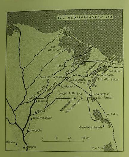
Below, Professor Hoffmeier, an Egyptologist, limited his research on the Exodus to Israel's leaving Egypt borders and understands the event is Ramesside. He understands that Rameses is Qantir which has Ramesside debris. Etham is somewhere in the vicinity of Lake Timsah at the east end of Wadi Tumilat. Pi-ha-hiroth means "the mouth of the canal" (kharru). The canal's mouth (Hebrew "pi-") empties into the north shore of Lake Timsah. The crossing of Yam Suph, "the sea of reeds" is Lake Timsah, which possesses reeds on its shores (A freshwater canal from the Nile to Lake Timsah is probably the source of the reeds). Succoth is Tjeku, a region within Wadi Tumilat near Tell er-Retabeh, extending toward Timsah. (cf. fig. 2. follwing p. 76. "Map of the Delta and north Sinai." James K. Hoffmeier. Israel In Egypt, the Evidence for the Authenticity of the Exodus Tradition. New York. Oxford University Press. 1996. ISBN 0-19-513088-X pbk.)
Critique: The dotted line suggests that Israel did not leave Egypt via Wadi Tumilat. Tell el Daba (Tell ed Daba) was abandoned in the mid 16th century B.C. Hyksos expulsion and resettled under Pharaoh Horemhab (reigned ca. 1321-1293 B.C.). Tell ed-Daba became a part of Pi-Ramesses/Qantir under Ramesses II and successors as the former expanded into the latter. The canals, extending from Lake Timsah to Pelusium, appearing on the map have _not been documented_ as to when they were constructed, it is "assumed" they "might" be Ramesside 19th Dynasty or even Dynasty 12. Gebel Abu Hassah possesses a Ramesside shrine. Tell el Maskhutah associated by some with Pithom and Succoth by others, has no Ramesside pottery debris, only mid 16th century B.C. Hyksos and late 7th century Saitic of ca. 610 B.C. Of interest is that Edouard Naville in the 1880's unearthed a stela at Tel el Maskhutah erected by Ptolemy II dedicating revenues to a "temple of Pikheret". Naville suggested Pikheret might be Pi-ha-hiroth of the Exodus.
Below, the Egyptologist K. A. Kitchen's map of the Exodus (He favors a Ramesside Exodus). Qantir is Rameses, Etham is the vicinity of Lake Timsah, Pithom is Tell er-Retabeh, Succoth is Tell el-Maskhutah. Mt. Sinai is possibly Gebel Musa, Kadesh is Ain el Qudeirat.(p. 627. Plate XXV. "Possible Route of the Exodus." Kenneth A. Kitchen.
On the Reliability of the Old Testament. Grand Rapids, Michigan. William B. Eerdmans Publishing Company. 2003. ISBN 0-8028-4960-1)
Critique: Tanis/Zoan not a pharaonic residence until ca. 1069 B.C. Pi-Ramesses/Qantir founded by Seti I and Ramesses II. Pithom/Tell er Retabeh has Ramesside pottery debris. Succoth/Tell el Maskhutah has NO Ramesside pottery debris, only mid 16th century B.C. Hyksos and late 7th century Saitic ca. 610 B.C. Clysma/Suez has a fortess erected by Ramesses III. Ramesside fortresses and way-stations line the biblical "way of the Philistines" across the N Sinai. Mt.Sinai/Gebel Musa has NO LBA or Iron Age debris. Hazeroth/Ain el Huderah has only Nawami tombs of the Stone Age. Di-Zahab/Dahab is no earlier than the Nabatean era, the 4th-2d century B.C. Kadesh Barnea/Ain el Qudeirat and Ain el Qadeis have sites of the Stone Age, Middle Bronze I and Iron II in the general vicinity. Elath/Tell el Kheliefieh is not earlier than 8th century B.C. Iron II.
Below, Kitchen's Exodus from Egypt. Rameses is Qantir; Migdol is a fortress somewhere on the El Gisr ridge
(p. 260); Pi-ha-hiroth is the canal between Lake Timsah and the Ballah Lakes district. For Kitchen Yam Suph or the "Red Sea" is "the reed sea" and is a generalized term which embraces the whole area from the Ballah Lakes, Lake Timsah, the Bitter Lakes, and the Gulfs of Suez and Aqabah (pp. 262-263). (p.628. Plate XXVI. "Route of the Exodus: Rameses to the Sinai Desert." K.A. Kitchen. On the Reliabliity of the Old Testament. 2003)
Critique: Tanis/Zoan is not a pharaonic residence until 1069 B.C. Rameses is Pi-Rameses/Qantir (founded in 13th century B.C.). Avaris of the Hyksos mid 16th century B.C. expulsion is Tell ed Daba. Pihahiroth means "mouth of the canal" which he locates at either Lake Ballah or Lake Timsah. Etham is near Lake Timsah. Succoth is Tel el Maskhutah. Pithom is Tell er Retabeh. Baal Zephon is a mountain somewhere east of the canal linking the Ballah and Timsah Lakes.
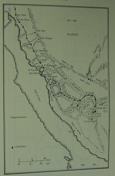
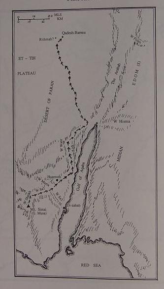
Below, Kitchen's Exodus Route from Ain Naba and Ayun Musa "the wells of Moses," to Mt. Sinai, Gebel Musa near St. Catherine's Monastery. Kitchen is vague for the siting of Marah, suggesting it could be anywhere between Ain Naba and Ain Hawara. He notes many associate Elim with Wadi Gharandal and is neutral on this. The Wilderness of Sin is for him the coastal plain south of Ras Abu Zenimeh extending as far south as the mouth of Wadi Feiran. South of the ancient Egyptian miner's Late Bronze Age anchorage of Bir el-Markh, he opts for two possible routes from the wilderness of Sin: inland via Wadi Baderah and the mountains east of the coastal plain to Wadi Feiran or via the coastal plain entering the mouth of Wadi Feiran. Rephidim is somewhere in Wadi Mukattab or the northwest portion of Wadi Feiran. Dophkah and Alush are somewhere between the coastal plain south of Ras Abu Zenimeh and Wadis Mukattab or Feiran (cf. pp. 268-270). (p. 629. Fig. 29. Plate XXVII. "Route of the Exodus, II: Etham Desert to Mt. Sinai." K. A. Kitchen. On the Reliability of the Old Testament. 2003)
For Kitchen the Wilderness of Paran is the desert between a southern Mt. Sinai (Gebel Musa, Ras Safsafa or Gebel Katharina, none of which have any Late Bronze or Iron Age debris) and Kadesh Barnea, the region of Ain el Qadeis and Ain el Qudeirat (none of which have Late Bronze or Iron I) which he suggests might also be called Rithmah (p.270-273); Kitchen suggests a rate of travel of 12-13 miles a day for Israel (p.273). From Gebel Musa, the route is to Ain el Huderah frequently identified with biblical Hazeroth which has Stone Age Nawami tombs (p.272). Kibroth-Hattaavah is somewhere around the bend of Wadi Sa'l to Wadi Murra (p.272) (p.630. Plate XXVIII. Fig. 30. "Route of the Exodus III: Mt. Sinai to Qadesh-Barnea." K.A. Kitchen. On the Reliabilty of the Old Testament. 2003)
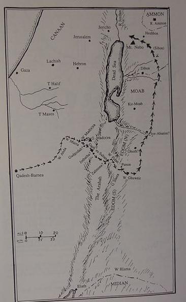
Below, Kitchen's final map shows the Exodus Route from Kadesh-Barnea (Ain el-Qadeis and Ain el-Qudeirat) to the Plains of Moab opposite Jericho. The route is via Wadi Abda (Greek: Oboda) and Wadi Murra thence via the Darb es-Sultan "the king's way" across the Arabah to Wadi Fidan to Punon (Feinan?) and Wadi Ghuweir then north to Oboth (identification not given), Iye-Abarim (apparently Wadi Hesa?) and Mt. Nebo. (p. 631. Plate XXIX. Fig.31. K. A. Kitchen. On the Reliability of the Old Testament. 2003)
Critique: Qadesh Barnea/Ain el Qudeirat has no LBA or Iron I. The biblical sites of Gudgodah, Jotbatha, Zalmona, Punon, Oboth and Iye-Abarim are not listed in the Index (Nor could I find them in the text). Elath might be Tell el Kheliefiyeh which is Iron II 8th-6th century B.C. Heshbon is probably Tell Hesban which is no earlier than Iron I, but as a fortified town worthy of being a capital of Sihon's Amorite empire, it would be the 8th-7th century B.C. site. Kitchen understands that Edom was probably unsedentary for the most part in the Ramesside Exodus of the 13th century B.C. and her nomadic peoples, were for him, powerful enough to prevent Israel crosssing her territory. He notes Ramesside pharaohs boasting of pillaging the tents of the Seirites. Ramesside pharaohs (Seti I -Ramesses V, ca.1291-1140 B.C.) controlled the copper mines at Har Timna (Gebel Mene'iyeh) in the southern Arabah, and Egyptian style houses exist at Ramesside Iron I Tell Masos in the Negev.
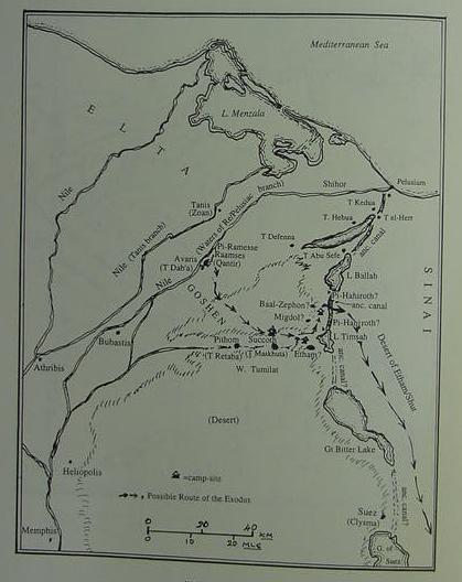
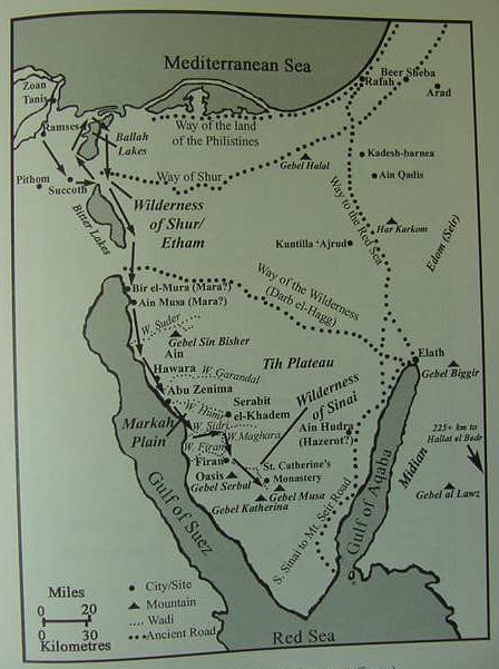
Hoffmeier's below map of the Exodus (2005). He seems to favor a Ramesside Exodus of the 13th century B.C.
He acknowledges that many of his identifications are _very tentative_ as no site in the Sinai has any archaeological debris of the Late Bronze Age (1540-1200 B.C.) the time period the Exodus occurred in according to some scholars.
Rameses is Qantir, Pithom is Tell er-Ratabeh, Succoth is Egyptian Tjekw associated with Wadi Tumilat, Etham is the vicinity of Lake Timsah; the crossing of Yam Suph is a northern portion of the Ballah Lakes. The wilderness of Etham/Shur is the Ishtmus of Suez; Marah [His Mara] is associated with Bir al Murr [His Mura] east of the port of Suez or Ain Musa; Elim is the Wadi Gharandal vicinity; the wilderness of Sin is the coastal plain of al Markha south of Abu Zenima; Dophka might be Serabit el Khadim or Wadi Maghara (an Egyptian mining camp south of Khadim); Alush might be Wadi el-Esh; Rephidim might be the Feiran Oasis or Wadi Refayid (between Feiran and Gebel Musa); Mount Sinai might be Ras Safsafa, Israel assembling on the plain of er-Raha; Hazeroth is Ain Hudera/Hudra; Kadesh Barnea is Ain el Qudeirat near Ain Qadeis. (James K. Hoffmeier. Ancient Israel in Sinai, The Evidence for the Authenticity of the Wilderness Tradition. Oxford & New York. Oxford University Press. 2005. ISBN 0-19-515546-7)
I seem to recall an article in one of the issues of the Biblical Archaeological Review magazine regarding "Why Israel's Exodus Route was headed for the southern Sinai." It suggested the rainfall there in the high
granite mountains provided water to sustain life, running off the rock to collect in wadies which could be exploited via wells or springs.
One of the many interesting observations made by Professor Hoffmeier, who is a trained Egyptologist, is that apparently the site of Mount Sinai/Horeb was known to Israelites as late as the Monarchy period (First Temple era) as the prophet Elijah fled there from Ahab's wrath (1 Kings 19:8, Late Iron Age II in archaeological terms).
I note that at the Feiran Oasis Judean Iron Age II pottery has been found of the 9th-8th century B.C. Hoffmeier's first choice for Mt. Sinai is Ras Safsafah, his runner-up choice is Gebal Serbal, near the Feiran [His Firan] Oasis (cf. pp. 144-148. James K. Hoffmeier. Ancient Israel in Sinai, the Evidence for the Authenticity of the Wilderness Tradition. Oxford & New York. Oxford University Press. 2005. ISBN 0-19-515546-7).
Caves do exist about the Feiran oasis and were occupied by Christian hermits, and Elijah is understood to have taken refugee in a cave at Horeb. Could the 9th-8th century B.C. Judaean pottery be "evidence" that in the days of Ahab who reigned in the 9th century BCE (ca. 869-850 B.C.) that some Jews were making "pilgrimages" into the southern Sinai to "reconnect" with their traditions of a Wilderness Wandering under Moses and an encampment at Mount Sinai/Horeb?
Professor Aharoni on the 9th-8th century B.C. Iron Age II Judaean pottery found at the Feiran Oasis:
"However, an extremely important archaeological discovery made during the
last survey of Sinai now compels us to re-examine all our previous
assumptions. An expedition headed by Professor Mazar examined the tell of
the desert oasis of Feiran. This is the principal oasis, stretching for a
few miles , of southern Sinai. It lies at the foot of the lofty Mount Serbal
and is fed by the melting snow that covers the summits of the high granite
mountains in winter. A purling stream provides water for graceful
date-palms, orchards and flourishing vegetable-gardens. Rising prominently
in the middle of the oasis is a tell on top of which many interesting
remains of a large monastery of the Byzantine period have been preserved,
and scattered all about the tell, over an area of about ten acres, the
remains of buildings and walls are discernable. A careful examination by the
Mazar expedition of the sherds they collected revealed that, apart from
numerous Roman-Byzantine and early Arab sherds, the site abounded in
Nabatean sherds. In addition, the site produced sherds of the Hellenistic
period, Persian sherds and some wheel-burnished sherds typical of the
kingdom of Judah, belonging to Iron Age II, i.e., the period of the kings of
Judah during the time of the First Temple. This, then, is the only tell
discovered so far in Sinai -perhaps the only tell there at all- displaying a
fairly prolonged continuity of settlement; at the very least, from the Iron
Age, ca. 9th-8th centuries B.C., through the Persian-Hellenistic and
Roman-Byzantine periods up to the early Arab period." (p.166, Yohanan
Aharoni, "Kadesh-Barnea and Mount Sinai." Beno Rothenberg, et al.
God's Wilderness, Discoveries in Sinai. New York. Thomas Nelson & Sons.1961,
1962)
The mention of a stream from Gebel Serbal providing water for the Feiran Oasis is interesting. Hoffmeier cites a statement by Randall in 1862 of a refreshing drink from a stream of water coming from a rock crevice at Ras Safsafeh near the St. Catherine's monastery:
"The Reverend D. A. Randall, who traveled to the Holy Lands in 1862, was
likewise impressed with er-Raha plain and Ras Safsafeh...He also noticed
that there was a (seasonal) water source located at Gebel Safsafeh, just a
ten-minute walk from the monastery, which would have been important to any
people staying in the area. He described it in the following manner: "A few
rods from us, flowing directly from a crevice in the granite rock of the
mountain was a copious stream of pure sweet water. How refreshing, after the
stale water we had so long drank!" (p. 145. James K. Hoffmeier.
Ancient Israel in Sinai, the Evidence for the Authenticity of the Wilderness
Tradition. Oxford & New York. Oxford University Press. 2005. ISBN
0-19-515546-7).
Hoffmeier noted that today (2005) a tourist village has sprung up on the plain of er-Raha, with a highway and electricity lines. I wonder, has anyone "ever bothered" to talk to the locals living there about _any ancient pottery_ or charred campfire wood being "accidently uneartherd" as foundations were being excavated for the various tourist buildings, or substratum laid for the highway, or postholes for the electric powerlines? An analysis of any pottery (if such exists from er-Raha) by a qualified archaeologist might shed more light on the Exodus traditions, while Carbon 14 Radioactive Decay dating of any charred wood from campfires (if such exists) would be helpful too.
If Mount Sinai is Gebel Musa or Ras Safsafah which approach would Israel have used, the Nagb Hawa or the Wadi es Sheikh to get to the plain of er Raha? E. H. Palmer (1868) used both approaches on two different occasions in his visit to the area to determine Israel's Exodus route. He had a baggage train of 42 camels accompanying him from Suez to Gebel Musa. He stated that the Nagb Hawa pass while being "the fastest and most direct approach" to the Plain of er-Raha, was very narrow and a steep ascent. It was suitable only for a small group on lightly equipped riding camels. Accordingly, the Camel train, took the el Watiya Pass, then bypassing Nabi Saleh it entered the er Raha plain via Wadi es Sheikh. On another occasion he, with a small group on lightly equipped riding camels, took the Nagb Hawa pass to get to the plain of er Raha. He concluded that due to Israel's size (600,000 warriors plus women and children), ox-drawn wagons (Nu 7:3-8), sheep, goats and cattle, that the _only_ realistic approach to the plain was via Wadi es Sheikh (cf. pp. 135-136. E. H. Palmer. The Desert of the Exodus, Journeys on Foot in the Wilderness of the Forty Years' Wanderings Undertaken in Connection with the Ordnance Survey of Sinai and the Palestine Exploration Fund. New York. Harper & Brothers, Publishers. 1872)
Palmer on Moses and a few elders possibly taking the Nagb Hawa pass and sending the baggage train on to meet them later via the el Watiya pass and Wadi es Sheikh:
"The words, "and there Israel camped before the mount," seem to me to imply a separate operation, and I should be inclined to interpret the passage thus: They were departed from Rephidim, or Feiran, and had reached the wilderness of Sinai, that is, the Sinai district at the mouth of the Nagb Hawa; and here they began to look out for a suitable place for a permanent camp. The spot chosen was the plain of Er Raha, "and there Israel camped before the mount," The operation of pitching camp for so protracted a stay as they were about to make would occupy a longer period than usual, and may even have extended over several days...Again it is quite possible that Moses and the chiefs of the elders took the short road through the pass, leaving the rest of the caravan with the heavy baggage to follow them around Wady es Sheik and come into camp next morning. Captain Wilson and myself being desirous on one occasion of pushing on to Jebel Musa by a certain day, actually adopted this expedient.
If it be objected that the distance from Feiran to the pass is too long for a single day's journey, I would answer that a day's journey is not necessarily restricted to eight or nine hours, and that the Israelites probably traveled lightly equiped, as do the Arabs of the present day. These, when they wish to reach a particular spot in a given time, often travel for six to eight hours, and then, after a short rest, resume their journey and perform the remainder by night. The Arabic language has a word used specially to express this mode of travel." (p. 136. Palmer. 1872)
Willcocks (1919) Proposed that Goshen extended from Wadi Tumilat to El Arish (the Egyptian border being El Arish). He proposed that Kadesh Barnea was Ain Kadis (modern Ain Qadis) in the Negev while Meribah Kadesh was another location at the southern border of Edom east of the modern port of Aqabah (his Akabah). He proposed a Mount Horeb (horeb= sun) and a Mount Sinai (sinai= moon) existed at both Kadesh sites (the Negev and Edom). Why two Kadesh sites? Deuteronomy 33:2 and Judges 5:4 suggested for him Mount Horeb and Mount Sinai bordered Edom. He had the Laws of Moses being composed at both locations Kadesh-Barnea's Mt. Horeb and Mt. Sinai as well as Meribah Kadesh's Mt. Horeb and Mt. Sinai (cf. pp. 76-85. Sir William Willcocks. From the Garden of Eden to the Crossing of the River Jordan. 2nd edition. 1919. London. E. & F.N. Spon. Please click here to read his book on the internet, digitalized by Google. Note: cf. p. 76 plate iv for his foldout map showing the Exodus' camp sites and the two Kadesh sites and the two Mt. Horebs and two Mt. Sinais).
For Maps of the Exodus Route drawn up by myself, the reader can click on the below urls.
I have proposed that two locations, one in the southern Sinai near the Egyptian mining Temple of Serabit el Khadim, called Gebel Saniya, and another site in the southern Arabah, at the Egyptian mining temple near Har Timna (Gebel Mene'iyeh), are the sites lurking behind the Mount Sinai traditions. Both sites have, in their general vicinity, the "required" Late Bronze - Early Iron I Age pottery debris demanded by scholars for the sacred mount's "successful" identification.
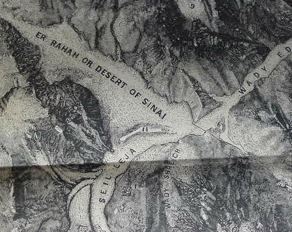
Below the plain of er Raha and its "banana-shaped" rise (no. 14, which looks like an 11 on the map) where the Daniella Hotel now exists and where a Neolithic settlement was found 1990-1991. Aaron's hill where the Golden calf was worhipped is no. 6. No. 9 is Gebel Suna (p. 91. E. H. Palmer. The Desert of the Exodus, Journeys on Foot in the Wilderness of the Forty Years' Wanderings Undertaken in Connection with the Ordnance Survey of Sinai and the Palestine Exploration Fund. New York. Harper & Brothers, Publishers. 1872).
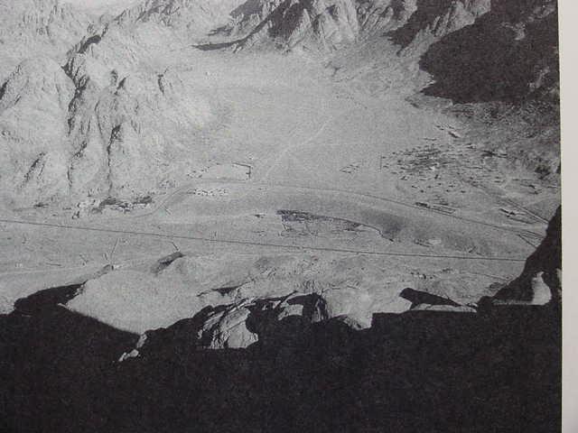
Below, a photo of the plain of er Raha from Ras Safsafeh (facing north) showing the "banana-shaped rise" with the Daniella Hotel located as small white buildings at the west-end of the elevation. Two highways encircle the below rise, seen as dark lines. A dirt track at the top of the photo heads for the Nagb Hawa pass (cf. p. 263. Joseph J. Hobbs. Mount Sinai. Austin, Texas. University of Texas Press. 1995. ISBN 0-292-73091-8). I wonder if further excavations on this banana-shaped rise might uncover Israel's camp? The dark shadow below the rise's middle is a garden.