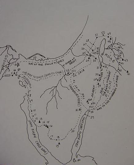
The Route of the Exodus and additional sites mentioned in the narratives
as envisioned by the ca. 560 B.C. Biblical Narrator
10 March 2004 (Revisions through 21 November 2009)
Please click here for this website's most important article: Why the Bible Cannot be the Word of God.
Please click here for my latest map (21 Nov. 2009) showing the site of Israel's "crossing of the Red Sea"
in the Exodus as being at Ras el Ballah (my Baal-zephon)
Note: A "goodly number" of the below site proposals _differ from proposals_ by other scholars and these "new" proposals are prefixed by an asterix ( * ). In some cases, I understand that a number of sites, in widely different locations, bear the same or similar sounding name and have been conflated together into a single location by the biblical narrator. For example, I understand two sites are conflated together under Mount Horeb/Sinai. Gebels Ghorabi(# 15) and Saniya (#16) near Serabit el Khadim (#14) in the southern Sinai, _AND_ Israeli: Har Timna (#36A [Arabic: Gebel Mene`iyeh]) in the southern Arabah at the eastern border of the Sinai. Both sites POSSESS the "missing" Late Bronze Age and Early Iron IA pottery debris "demanded" by professional scholars in siting the sacred mount. I find "Seir" at three separate locations, 1) Gebel esh Shairah (#21) in the Sinai, west of the modern port of Eilat; 2) Esh Shera in Edom on the east side of the Arabah; 3) The Hill Country of Judah, seized by Edom after 587 B.C. Please remember that the Arabic article el/El can also be rendered as al/Al whilst et/Et is at/At on various maps by different publishers. The late Israeli scholar, Yohanan Aharoni suggested that biblical sites might be preserved as Arabic toponymns from either a Hebrew, Aramaic, Greek or Latin recension (cf. pp. 105-130. "The Study of Toponymny." Yohanan Aharoni. The Land of the Bible, A Historical Geography. 1967-1979. Philadelphia. Westminster Press). My research below, bears him out. That is to say, a number of "new" proposals, (below) I suspect are derived from the Greek Septuaginta and Latin Vulgate rather than the Hebrew of the Massoretic text. NOTE: By clicking on the blue urls within the below parentheses you are taken to various "Topographical Maps" made by Professional Cartographers showing elevations and land forms, of scales from 1:50,000 to 1:250,000 made from between the 1870's to the 1990's. For a selection of "Route of the Exodus Maps" by other scholars like Yohanan Aharoni, William H. Stiebing Jr., Menashe Har-El and others please click here.
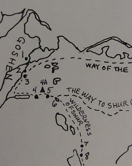
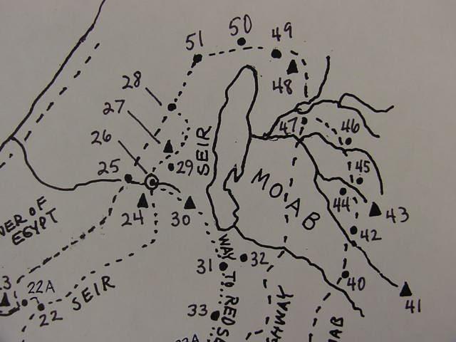
4A. *Shur/Shuwr(Abu Suwayr in Wadi Tumilat) 35. (Voided)
Wilderness of Shur/Etham between 6-7 (conflated with Gebel Saniya, Mt. Horeb/Sinai)
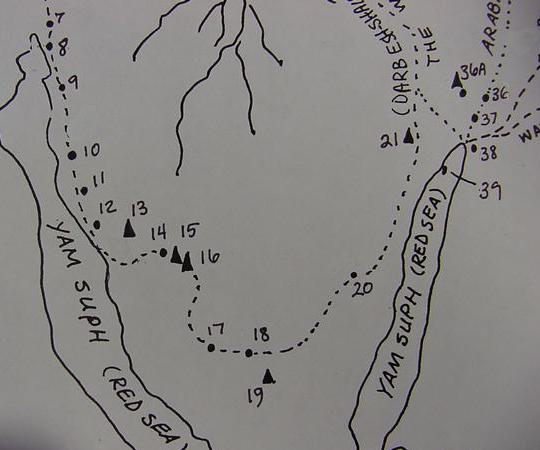
9. Red Sea/Yam Suph encampment 39. Jezirat el Faraun
10. *Wilderness of Sin LXX: Sina (El Sanawi) 40. *Iye-Abarim, LXX: Achalgai
(River of Zered, headwater of Wadi Hafire)
17. Paran, wilderness of (Feiran Oasis) 47. Dibon (Dhiban)
18. Kibroth-hatta-avah ([Egeria's] Sheikh Awad) 48. Mount Nebo (en-Neba)
20. Hazeroth (Ain el Huderah) 50. Jericho (Tell es Sultan by Eriha)
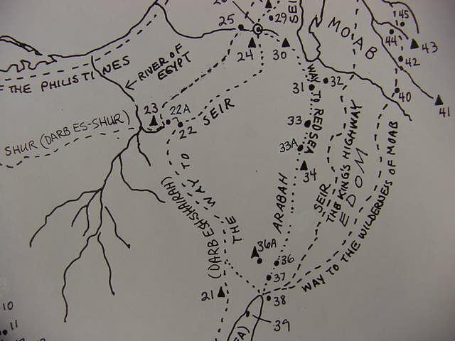
23. *Gebel Musraq (gives its name to the "river of Egypt [Mizraim],"
Wadi El Arish near Qusaima/Azmon)
28. Hebron
29. Arad (Tel Arad)
16 Jan 2006 Update:
Another "serious problem" in identifying Israel's encampments is that there is _no agreement_ among authorities as to the distance Israel traveled each day between camps.
Professor Hoffmeier noted that several ancient itineraries suggested that caravans consisting of either camels or donkeys could attain a daily rate of 15 to 20 miles and he suggests that this is Israel's rate of travel in his Exodus campsite proposals. The problem? Other scholars dispute this. They argue that Bedouin nomads who make their living herding goats or sheep usually do not exceed anywhere from 6 to 10 miles a day so as to not exhaust their flocks. They argue that as Israel is portrayed leaving Egypt with flocks of goats and sheep and herds of cattle it is impossible for her to achieve the daily rate of a camel or donkey caravan. The problem? If Israel's daily rate of travel is determined by her flocks then she could not have gone more than 6 to 10 miles each day between encampments. This is a "very serious" problem! Why? Because NO PROPOSAL from any authority (biblical scholar) can get Israel from one proposed campsite to another in one day at a rate of 6 to 10 miles a day! As proposed by Hoffmeier, the currently favored campsites are attainable if 15 to 20 miles a day is achieved. To illustrate what I mean: Gebel Musa or Ras Safsafeh near Saint Catherine's monastery is favored by some to be Mount Sinai and either Ain Qadeis or nearby Ain Qudeirat is thought to be Kadesh Barnea in the Negev. We are informed it is 11 days journey by the way to Mount Seir from Mount Horeb (Mt. Sinai) to Kadesh (De 1:2). The actual distance as the crow flies is about 160 miles. This is possible if Israel covers 15 miles a day or 165 miles in 11 days. If her flocks of goats, sheep and herds of cattle allow only 6 to 10 miles a day it is not possible. At 6 miles a day 26 days would be needed. At 10 miles a day 16 days would be needed.
Hoffmeier, refering to Beitzel's investigations:
"This figure precisely lies between the twentyfour and thirty-two kilometers (fifteen and twenty miles) per day that was reckoned based on comparitive travel distances from ancient texts." (p. 144. James K. Hoffmeier. Ancient Israel in Sinai, The Evidence for the Authenticity of the Wilderness Tradition. Oxford & New York. Oxford University Press. 2005. ISBN 0-515546-7)
Beitzel (emphasis mine in capitals):
"Itinerary texts from the Mosaic period stipulate that caravans were able to cover no more than about 20-23 miles per day. With the Exodus, however, the size and the background of the group, when combined with the factors of accompanying women and children and flocks and herds (Ex 12:38; 34:3; cf. 17:2; Nu 20:19), eliminate any possibility...The average daily distance maintained by modern bedouin moving from camp to camp _IS_ABOUT _SIX MILES_." (p. 91. Barry J. Beitzel. The Moody Atlas of Bible Lands. Chicago. Moody Press. 1985, 1988. ISBN 0-8024-0438-3)
Bryant G. Wood, a trained archaeologist observes : "A large group of pastoralists moving with their possessions and animals can cover _no_more_than _SIX MILES_ in_a_day, and usually less (Conder 1883: 79; cf. Beitzel 1985: 91). The limiting factor is the animals. When the Israelites left Egypt, they had "large droves of livestock, both flocks and herds" (Ex 13:38). " http://abr.christiananswers.net/jebel_thoughts.html
Professor Har-El prefers a daily rate of travel for Israel of about 6 miles, based on his once having been a shepherd himself. He is critiquing Shafei's 1946 proposal for the Exodus route from Rameses to Yam Suph (emphasis mine in capitals):
"Shafei's map indicates that the Israelites covered 18 km. on the first day of the journey, 26 km. on the second, and 24 km. on the third. This view is entirely untenable for the following reasons: (a) Old people, women and children could hardly progress at such a rate; (b) Herds with their young cannot cover such long distances without collapsing on the way (I know this from my own experience as a shepherd); (c) Such a large mass of people, weighed down by large quantities of baggage and heavily laden with posessions, could not possibly have made such rapid progress. Conder's observation that the Bedouin who move camp travel at _A MAXIMUM OF SIX MILES A DAY_ also provides support to this point of criticism. His estimate refers to small groups of Bedouin who are properly prepared for their move, in contrast to the large numbers of the Israelites who left Egypt in a hurry, without having made preparations for their journey."(p. 167. Menashe Har-El. " Criticism of Shafei's View." The Sinai Journeys, The Route of the Exodus. San Diego, Calfornia. Ridgefield Publishing Company. 1983. ISBN 0-86628-016-2 [first published in Hebrew 1968, by Am-Oved Publishing Ltd. Tel Aviv])
One individual noted (in an e-mail to me 09 Oct 2005): "Another Archaeologist, Clark Hopkins (of Yale) while directing a dig at Dura-Europas in the Syrian desert, noted that herders were moving 8-10 miles a day in areas where there was not enough pasture to satisfy the small livestock."
All this is to say, that if it is "impossible" for Israel to attain the daily rate of travel of a camel or donkey caravan because of the sheep, goats and cattle accompanying her, then ALL SCHOLARLY PROPOSALS (including my own) ARE DOOMED TO FAILURE, as NONE present an Exodus route based on a daily rate of travel of not more than 6 to 10 miles a day between _all_ the encampments!
Bible scholars such as Burkhardt and Robinson who explored the Sinai's Exodus Route in the 19th century A.D. did so by camels with Arab guides. These camels' pace was about 2 miles an hour and a day's trek was usually about 10 hours or roughly 20 miles a day. It is this phenomenon that lies behind their proposals for various sites of the Exodus, assuming a daily rate for Israel of 20 miles. Their proposals based on this phenomenon lie behind the identity of Marah with Ain Hawara, Elim with Wadi Gharandal, Sin with the coastal plain south of Ras Abu Zenimeh, and Gebel Musa being 11 days travel _by camel_ to Ain Qadeis and Ain Qudeirat.
Because of the above "anomalies" I have the following proposals to make:
1) The encampments presented in the Exodus account are perhaps a "late fabrication" of the Iron II period (9th-6th century B.C.) and are based on a "genuine itinerary" as _achieved by camel or donkey caravans_ which perhaps traversed the southern Sinai from the Negev to Egypt. Their daily rate of travel being 15 to 23 miles a day. I note that archaeolgists found at the Feiran Oasis pottery in the southern Sinai pottery sherds from Iron II Judah of the 9th-8th century B.C. Perhaps a caravan from Judah left these shards enroute to Egypt? If so, then the Exodus route and its encampments may be based on data from such caravans.
2) If 1) is "correct" then it follows that the route of a real Exodus is _not_ recoverable, as sheep, goats and cattle could not achieve the rate of travel of a camel/donkey caravan. Professor Hoffmeier's proposal of sites for the Route of the Exodus is pretty much that of earlier scholars since the 19th century A.D. explorations by camel of various Bible scholars (Burkhardt, Robinson, etc.). To me it makes sense, a camel or donkey caravan's encampments are being preserved in the Exodus account.
3) NO SCHOLARLY PROPOSAL (myself included) for the "Route of the Exodus" -to date- is based upon a _realistic_ travel rate of goats, sheep and cattle of not more than 6 to 10 miles a day for _all_ the encampments.
4) If employing a daily rate of travel for Israel of not more than 6-10 miles a day, the "most likely route" of the Exodus _it appears to me_ would be the Arabic Darb es-Shur, identified by some with the Biblical 'Way to Shur', a track from Beersheba to Muweileh, and Bir el Hasanna, which then crosses the northern Sinai terminating at Lake Timsah and the east end of Wadi Tumilat. The problem? Not even this "much shorter route" can be reconciled with the list of encampments from Rameses to Kadesh Barnea using a daily travel rate of 6 to 10 miles a day. One of the "problems" with this route is that after crossing Yam Suph, Israel wanders 3 days in the wilderness of Shur then stops at Marah, then Elim, then the shore of Yam Suph AGAIN. If Yam Suph is the region embracing the Ballah Lakes, Lake Timsah, the Bitter Lakes and Gulfs of Suez and Aqaba as proposed by Professor K. A. Kitchen, then where is the SECOND Yam Suph on the Darb es-Shur?
Please click here (and scroll down to the 15 Jan 2006 update) for Yam Suph's location _if_ Israel's daily rate of travel _was no more than 6 miles a day_ due to flocks of sheep accompanying her as advocated by Conder, Beitzel, Wood and Har-El. Many scholars associate Rameses, where the Exodus began, with Qantir (Pi-Rameses). Day One of the Exodus: Rameses/Qantir to Succoth: 6 miles. Day Two of the Exodus: Succoth to Etham: 6 miles. Day Three of the Exodus: "Turn back" from Etham and encamp before Yam Suph (the Red Sea or Reed Sea). If Israel is "turning back" on herself from Etham to Yam Suph is this sea between 6 to 12 miles from Rameses/Qantir? I have located TWO areas within 12 miles of Qantir (Rameses?) which possess bodies of water for Yam Suph. The maps show these bodies of water to be "intermittent lakes," at times dry and other times filled with water. That is to say, ALL the "earlier" scholarly proposals for Yam Suph do not fall within the parameters of between 6 to 12 miles from Rameses/Qantir, such as Lake Bardawil in the northern Sinai, Lake Ballah, Lake Timsah, the Bitter Lakes, the Suez Gulf. The widely held notion that Succoth is a Ramesside Egyptian region called Tjeku in Wadi Tumilat and Etham is near Lake Timsah ALSO FALLS OUTSIDE the parameters of sites lying no more than 12 miles from Rameses/Qantir. Of course if Israel "could exceed 6 miles a day" with flocks of sheep and goats and herds of cattle then the parameters can be expanded. To Get to Tjeku/Succoth from Qantir/Rameses in TWO DAYS, the rate of travel would have to be about 20 miles a day. Can sheep, goats and cattle (with their "Spring born" young lambs, kids, and calves) _really_ be driven 20 miles a day without dying of exhaustion?