Maps of Eridu, Tell Abu Shahrein/Shahrain, the Mesopotamian Garden of Eden;
Including photos of Ur, Tell al Muqqayyar/Mugheir, where Abraham lived,
based on Satellite photos
22 Feb. 2009
Revisions through 16 Sept. 2019
To date (17 March 2009), I have not been successful in finding any information on Eridu's trapzoidal walls appearing on recent satellite photos: when they were created, by whom, and whether or not they are ancient or modern. If you 'know' please contact me via e-mail by clicking here and I will make "corrections" to this article, Thanks.
=====================================================================================
Special Update of 21 April 2009: The walls of Eridu are modern features according to Dr. Collins of the British Museum, London (My thanks to Dr. Collins for permitting his reply to be posted):
Dear Mr. Mattfeld,
Thank you for your email which has been forwarded to me from the Information Service.
I was very interested to read your suggested identifications for features visible on Google Earth in the area of ancient Eridu. As you know, the reading of satellite images is extremely difficult and I am glad you have been in contact with Dr. Elizabeth Stone who is an expert in this field - indeed, her work on the recent survey was invaluable to us. I am not an expert in satellite imagery myself but I can say from my experience on the survey that the areas surrounding these ancient sites were covered with modern roadways and military constructions - there was clear evidence of military activity around the mounds of Eridu with burnt-out vehicles and oil drums. Major roads were constructed in the region, especially during the Iraq-Iran conflict; these are built on raised levies and this might give the impression in a satellite image of a fosse-ditch. The mounds of Eridu have been extensively surveyed, both at the time of excavation and more recently, including the use of aerial photography (there are photographs of ancient sites made by the RAF as early as the 1930s) and there is no evidence for an ancient wall around the site. One feature in a Google Earth image in your report which I can positively identify is the US military airbase at Talil, next to the site of Ur. This is the large, rectangular feature beside the mound of Ur which you have suggested may be the 'down-town' area of the ancient site - alas, it is a huge modern creation, built around a smaller airbase which was already there in the 1930s. I would also suggest that the image posted on Google Earth showing the sun and water was not taken at Eridu as there has been no extensive water close to the site in modern times.
I am sorry I cannot be more precise with the dating of these satellite features but I believe most of them to be modern.
Sincerely,
Dr. Paul Collins
Curator (Later Mesopotamia)
Department of the Middle East
The British Museum
=====================================================================================
Thompson (1919) described a scene of desolation all about him as he stood atop the ruins of the ziggurat called Tell Abu Shahrein (Enki/Ea's Abzu shrine). He appears to be unaware of Eridu possessing any walls for he makes _no_ mention of a trapzoidal fosse-ditch wall encompassing the area.
Thompson, as quoted by Maisels:
"From the ziggurat as far as the eye can see there is naught but awful solitude; you look down on sombre desert which encircles you for miles. Northwards lie the flat lands, yellow in April and unrelieved except for sparse arabesques of salt speading like mares'-tails in a breezy sky, while afar, just visible as a little pimple in the mornings but blotted out in the afternoon haze, is the temple-tower of Muqaiyar. Towards the north-east, especially when the sun is setting, the sandstone ridge on the skyline is thrown into vivid relief as a white streak six miles away. Eastwards, not far from the mound, the grass has sprung up, marking the dry site of the winter lagoon which lies between you and the sandstone ridge; southwards towards Dafna and Qusair are the distant low sandstone hills circling round and completing a wide arc to westward. Between you and the sunset is a broad green tract of scrub and coarse grass wherein lie the wells two miles away. Not a tree is in sight, and the only fuel is that provided by the little dry brushes."
(p. 131. "The Heartland of Cities." Charles Keith Maisels. The Emergence of Civilization, From hunting and gathering to agriculture, cities, and the state in the Near East. London & New York. Routeledge. 1990, 1999)
The earthen levee walls shown about Eridu in the satellite images do _not_ exhibit the extremes of weathering or erosion and sediment coverage one would expect after some 4000 to 3000 years of exposure to the elements: wind, rain, and dust storm. These walls have no gate openings perhaps their purpose is to prevent the area from being flooded in the months of May, June and July by the nearby Sebkhas created by a flooding Euphrates river?
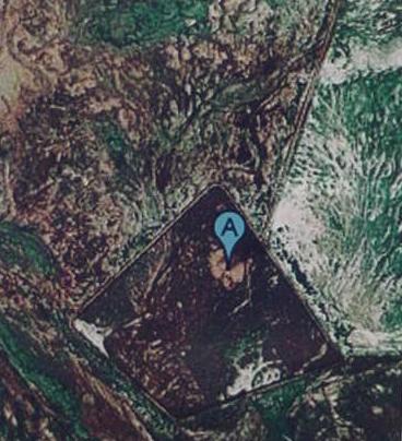
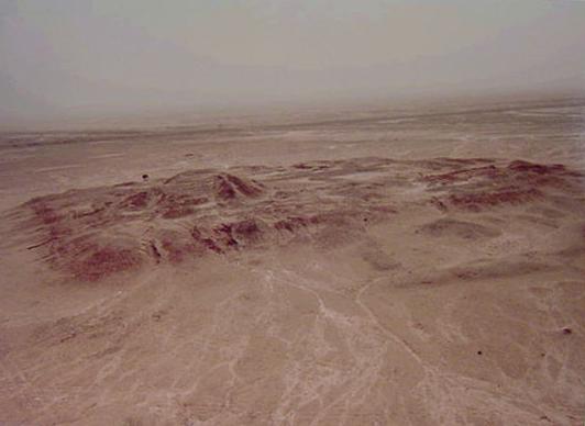
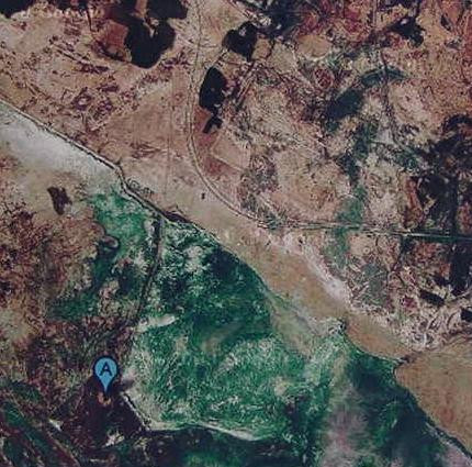
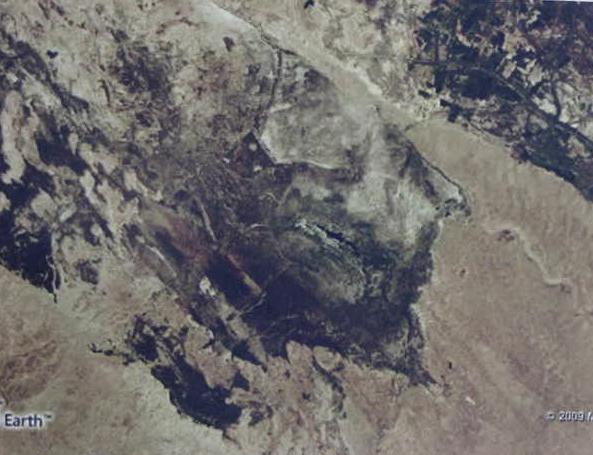
Below: A Satellite image (10 miles above the Earth) of ancient Eridu, Tell abu Shahrein, marked by a blue tag with an A on it (the Ziggurat mound). North of the blue tag and within the perimeter wall is another mound with exposed excavated buildings, an administration center in antiquity (?) which is viewable at 1396-578 feet above the Earth. Note that the four corners of Eridu's perimeter levee wall appears to be orientated to the four cardinal points of a compass: north-south, east-west, the same orientation holds for the four-cornered shrine atop Tel Abu Shahrein.
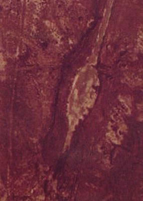
Below, a close-up (3000 feet above the Earth) of the terminus of the levee highway coming from Ur (12 miles or 24 kilometers away). This terminus or parking lot (?) is just east of the Eridu "Ziggurat mound" which is marked with the blue "A" tag.
Some viewers may be interested in pursuing a "more scholarly study" of Eridu's features via its satellite images, the below instructions "may be" of some help:
Download "Google Earth" and also MicroSoft's "Virtual Earth" and follow their directions, keying in Eridu, Iraq.
Regretably, Google Earth's satellite photos of Eridu and its fosse (?) are of two different quality satellite images. The west half of the site is dark and very blurry. It cannot be viewed at 1900 feet above the earth like the eastern half of the site. Regretably Virtual Earth does not permit viewing at 1900 feet above the earth for Eridu so no canals can be seen within its walls.
Why my interest in Eridu?
I understand it is "one" of several sites behind Genesis' Garden of Eden story.
In fact it is the "principal" site. How so?
Adam is told "Do not eat the forbidden fruit or you will die" by God (Yahweh-Elohim).
Some Liberal Scholars possessing PhDs in the fields of Biblical and Ancient Near Eastern Studies for over 100 years (since the 1890s) have identified Adapa of the Adapa and the South Wind Myth as "one" of the pre-biblical Mesopotamian fictional protagonists who was transformed by the Hebrews into Adam and they have proposed Eridu as the Mesopotamian equivalent of Genesis' Garden of Eden (cf. Professor Archibald H. Sayce of Oxford University, 1887 for Eridu as Eden's Garden).
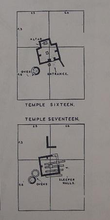
Adapa lived at Eridu when his god Ea warned him "do not eat the bread of death or you will die," presaging God's warning to Adam about not eating the forbiddden fruit. Unlike Adam, Adapa obeys and thereby loses out on a chance to obtain immortality for himself and mankind. His god, Ea (Sumerian: Enki), had lied to him, he was willing to allow man (Adapa) to possess "godly forbidden knowledge" (which outraged the supreme god Anu) but denied him immortality. Unlike Yahweh, Anu decides if this man has godly-forbidden knowledge I might as well make him a god by giving him immortality so he summons the forbidden food, Ea's "bread of death" for Adapa to eat. In other words, the Mesopotamians understood man lost on a chance to obtain immortality not because he had forbidden knowledge, but because his god (Ea) tricked him into believing it was the "bread of death" when, in reality, it was the "bread of life" and he would die if he ate it. Please click here for the story. Adapa served Ea his food, he was a baker, a fisherman and he provided drinking water for Ea to consume. Below, plans showing "temples" 17 and 16, Eridu's earliest temples of mud-brick for Ea (Sumerian Enki), note the ovens nearby Adapa would have used to bake Ea/Enki's bread in. It was "bread of life" that Anu offered Adapa at his heavenly residence which Adapa refused to eat because Ea told he it was the "bread of death" and he would die if he ate it (the "bread of death" was recast in Genesis as a "fruit of death" and the "bread of life" was recast as a "fruit of life"). So man lost out on a chance to obtain immortality because his lying god at Eridu had conned him. In the New Testament Jesus Christ is portrayed as being the bread of life, tearing apart bread and telling his followers to eat it as it represents his body and to drink wine symbolic of his shed blood. Just think, the below humble bread oven is probably behind the Mesopotamian myth of how Adapa was tricked into not eating the bread of life and forfeiting immortality for himself and mankind. The gods had created man to toil on their behalf providing them with life's neccessities: food, shelter and clothing, thereby giving themselves an eternal rest from earthly toil in the edin's city-gardens. The "bread of life" offered Adapa by Anu in heaven probably had its origin at Eridu's bread oven and he had probably baked it! How so? One of man's duties is to feed the gods with earth-grown and prepared food. So, Adapa had been presented his own bread which as a baker for Ea he had made at Eridu. The earliest temple is 17 (al 'Ubaid period circa 4900 B.C.), temple 16 was built atop of it. Even had Adapa eaten the forbidden food he still would have died. Why? The gods themselves could die. They slew each other in myths and their bodies wound up in the underworld and they ate the "bread of life" daily that man their servant prepared for them. If the gods' fleshly bodies are not immortal the same would apply to Adapa's fleshly body. Death for the Mesopotamians was of the fleshly body only. The spirit lived on in the underworld as ghost or shade. So, in a sense, man and god do not die, they live forever as shades or spirits in an underworld euphemistically called at times the edin. Only their fleshly bodies die. To "live again" is to have one's fleshly body arise from the underworld and once again walk the earth's surface and feel the sun's heat. Hence the reason Christians must possess fleshly bodies at the resurrection and walk the earth's surface.
Below, a closeup of the levee highway terminus or parking lot (?) east of the Eridu Ziggurat mound which I earlier, in error, thought was Eridu's quay.
Enki hymns mention the "good quay" his boat called the Ibex of the Abzu is moored at and that at this quay Inanna of Uruk visited Enki via a boat from Uruk called the Boat of An (the god An had a temple at Uruk). The below hymn suggests that the id nun canal "ended" at a quay or harbor at Tell Abu Shahrein (the ziggurat mound). Zarins' map shows the canal approaching from the NW while Fuad Safer claimed he found remains of a canal several kilometers SW of the mound. Until further excavations are done one is "left in the dark" as to tracing the id nun canal's route.
"...Eridu...the noble shrine, the Abzu...build with skill the staircase of Eridu at the good quay,
moor the Ibex of Eridu at the good quay...the noble quay..."
(p. 44. Samuel Noah Kramer & John Maier. Myths of Enki the Crafty God. Oxford University Press. 1989)
"Holy Inanna gathered all the me,
loaded them onto the Boat of An,
shoved off the Boat of An from the quay."
(p. 64. Kramer. Myths of Enki the Crafty God. 1989)
Enki hymns speak of the "pure water" (freshwater?) provided the Abzu shrine by the "prince's canal" id Nun (id = "canal" or "river," nun = "prince"). Professor D. T. Potts associates the id nun canal with the city of Ur (p. 29. Mesopotamian Civilization, The Material Foundations. 1997).
"Abzu, a shrine built for the Prince,
house, a holy banquet-hall where pure food is eaten,
where water is drunk from the pure canal of the Prince..."
(p. 94. Samuel Noah Kramer & John Maier. Myths of Enki the Crafty God. Oxford University Press. 1989)
Leick's translation of the same above verses:
"E-unir, which has grown high, (uniting) heaven and earth,
Foundation of heaven and earth, Holy of Holies Eridu Abzu, shrine erected for its prince,
House, holy mound, where pure food is eaten
Watered by the Prince's pure canal..."
(pp. 26-27. "Eridu, Creating the First City." Gwendolyn Leick. Mesopotamia, The Invention of the City. 2001, 2002. London. Penguin Books)
The Adapa and the South Wind myth, set in Eridu, speaks of Adapa's fishing boat leaving the "quay of the New Moon;" The Sumerians called the Full Moon Nanna and the New Moon (when the first lunar crescent appears) was called Asimbabbar. Some cylinder seals show a crescent moon near Enki's head. Is this crescent moon an allusion to the "quay of the New Moon" at Eridu from whence Enki by boat visited the shrines of Sumer?
"...Adapa, the one of Eridu...at the holy quay, the Quay of the New Moon, he boarded the sailboat...Adapa replied to Anu: "My lord, for the household of my master, in the midst of the sea I was catching fish. The sea was like a mirror. But the south wind came blowing and submerged me."
(p. 76, 78. "Adapa." James B. Pritchard. Editor. The Ancient Near East, An Anthology of Texts and Pictures. Princeton, New Jersey. Princeton University Press. 1958. Paperback edition)
The below map of ancient Ur (James Henry Breasted. Ancient Times A History of the Early World. Volume I, The Ancient Near East. Boston. Ginn & Co.1963. Second Revised Edition) reveals two quays or harbors _within_ the city wall encircling the tell mound of Muqayyar. The Enki hymns speak of a quay made of carnelian stone for his boat to dock at. Most probably this stone-lined Quay is to be found within the the stone foundation walls encircling the base of the Abu Shahrein mound.
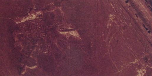
What is "strange" about the below Eridu satellite photo (1300 feet above the Earth) is that the harbor (?) at the end of the canal (?) from Ur is not within the encircling wall of Tell Abu Shahrein like Ur's walls. Also "strange" is that the canal from Ur is filled-in with earth at the point it intersects Eridu's fosse. No ship can enter or leave Eridu because of this blockage. As revealed by satellite photos, what appear to me to be tire tracks (?) descend from the east side of the canal from Ur, into the canal ditch, then ascend the earthen blockage and descend into the canal on the interior of the wall. Today, there is no other way to get into Eridu as revealed by the satellite photos (unless by helicopter). 16 August 2009 Update: What I thought was Eridu's harbor (below) is apparently a parking lot east of Tell Abu Shahrain, the southern terminus of the levee highway going north to Ur. Eridu's harbor is most probably the "indentation" in Eridu's mound wall east of the Ziuggurat (see Hawkes' map, below).
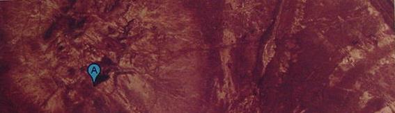
Below, a closeup of the "Palace" mound or Tell (1300 feet above the Earth), showing the remains of excavated apartments understood by the excavators to be administratve quarters and residence for the staff servicing the Ziggurat and its banqueting hall and shrine atop Tell Abu Shahrein (the Abzu House).
Dr. Gwendolyn Leick, PhD, Karl Franzens University, Graz, Austria, Fellow of The Royal Anthropological Institute, on Eridu, its topography, city wall of gypsum stone instead of mud-brick, and seven tells or mounds:
"Eridu is the Mesopotamian Eden, the place of creation...the Mesopotamian Eden is not a garden, but a city, formed from a piece of dry land surrounded by the waters. The first building is a temple. Then mankind is created to render service to god and temple...Eridu is the ancient name of a site now known as Abu Shahrein...the city...was built upon a hillock within a depression about twenty feet below the level of the surrounding land, which allowed the subterranean waters to collect together. This swampy place can still become a sizable lake in the months of high water. The earliest Mesopotamian texts, from the early third millennium, underline the importance of this lagoon. In Sumerian this was known as the Abzu (in Akkadian Apsu).
(pp. 1-3. "Eridu, Creating the First City." Gwendolyn Leick. Mesopotamia: The Invention of the City. London. Penguin Books. 2001, 2002)
Apparently the Ziggurat mound west of the canal harbor (?) in the satellite photos is Tell Abu Shahrein (10 kilometers = 6 miles).
"The mound of Eridu, called Tell Abu Shahrein, which lies just some 24 kilometres south of Ur...is a typical cone-shaped tell, or ruin-heap, half a kilometre in diameter, raising some 25 metres above the plain. Six smaller mounds were dotted around in the vicinity, indicating that the population centre moved throughout time, perhaps in accordance with the lagoon's shifting shoreline." (p. 4. Leick)
"The Iraqi team began work on the acropolis, where the remains of a large stepped monument or ziggurat very similar to the one at nearby Ur were clearly visible. This structure could be dated with the help of some inscribed bricks to the kings Ur-Nammu and Amar-Sin, rulers of the Third Dynasty of Ur (c. twenty-first century)...At the lowest level, on a dune of clean sand, they discovered the very first building, a primitve chapel no larger than 3 metres square...the proposed date for this chapel is 4900 or Ubaid level I. The whole building, and all those of subsequent layers, were of sun-dried brick." (pp. 5-6. Leick)
Leick on Tell Abu Shahrein:
"Limestone and sandstone occur naturally at Eridu and it is one of the few cities in southern Mesopotamia where the city wall was built of Gypsum. The main temple was built of gypsum...a retaining wall surrounded the whole of the mound...For a few hundred years Eridu continued to exist primarily as a ceremonial (or religious) centre...it was completely abandoned...only the main mound left standing...When, after some centuries, the area was once more inhabitated, the population chose another spot, about a kilometre to the north, and few efforts were made to rebuild the main mound...The site only became important again in the Early Dynasic II Period (c. 2500). Either a ruler of the First Dynasty of Ur or a local governor built a large palace, composed of two identical buildings side by side...The excavators suggested that whoever had resided in that palace also attended to the sanctuary on the main mound...years later, from the time when the kings of the Third Dynasty of Ur (Ur III) turned their attention to the old shrine of Eridu. The main architect of this project was king Amar-Sin (c. 2046-2038). His father had built the colossal temple precinct with a massive ziggurat at Ur and the son followed that example. Inscribed bricks proclaim that Amar-Sin 'king of the four quarters' built for Enki, his beloved king, his beloved Apsu'...It was also a destination for the cultic journeys of the gods, a popular spectacle and ritual in which the statutes of various deities travelled by boat from one temple to another, up and down the country...In the mid first millennium...the forsaken ruins once more receive royal attention when Nebucharezzar II (605-562) attempted some restoration, according to a few inscribed bricks and administrative documents. Thereafter Eridu's temple fell into permanent ruin." (pp. 18-19. Leick)
Below, an aerial photo of the Eridu ziggurat mound, approaching it from the southwest. The corner closest the viewer (viewer's left) is the western corner, left of it is the northern corner, to the right of this is the eastern corner and at the viewer's farthest right is the southern corner (please click here and here for more photos of Eridu). Note the mound's four corners are orientated north-south, east-west.
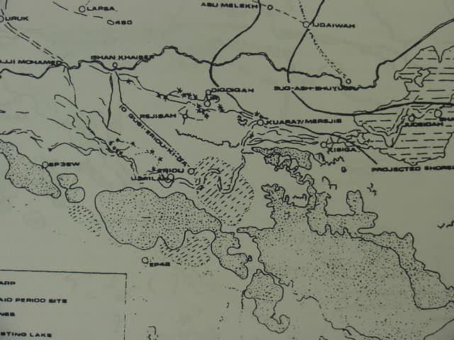
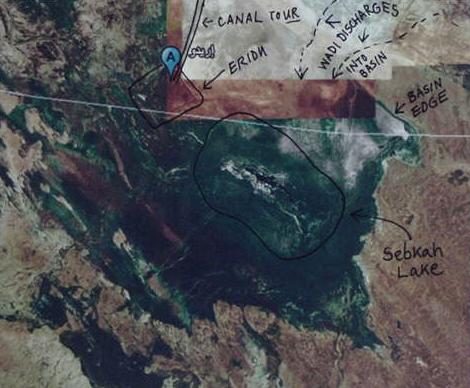
Below, a map of Eridu showing a large Sebkha to the east of Eridu, a lake that periodically fills up in the rainy season along with times of high watertable (?) then "disappears" in the dry season and low watertable. Leick suspects this phenomenon is behind the Sumerian notion of the abzu, waters from under the earth arising to fill hollows in the earth. The map scale suggests this sebkeh is about 20 kilometers (12 miles) in length and 10 kilometers (6 miles) in width, about the size of the Sea of Galilee in Israel (for the below map of Eridu cf. figure 1. p. 58. Juris Zarins. "The Early Settlement of Southern Mesopotamia: A Review of Recent Historical, Geological, and Archaeological Research." pp. 55-77. Journal of the American Oriental Society. Vol. 112, No. 1. Jan.-Mar. 1992). Zarins' map shows what looks to my "untrained eye" a branch of the Euphrates from the west, passing by Eridu's south side and continuing eastwards across a Sebkha towards the Tell al Lahm. Is this map correct? Could via a boat, one go east from Eridu to Tell al Lahm? I understand Eridu is in a _basin_ if that be so how does the Euphrates' channel "leave" the Eridu basin and take one "east" to the Tell al Lahm?
It strikes me that the channel east of Eridu "should be" draining from east to west, emptying _into_ the Eridu basin.
In other words one cannot get to Tel al Lahm via this eastern channel as its drain is westwards towards Eridu and not eastwards away from Eridu. Enki, however, could, via boat, "go east" from Eridu by using the id Nun "Prince's Canal" canal going due north from Eridu to Ur and link up with the canal going east from Ur to Tell el Lahm.Note: Dr. Zarins, PhD, does _not_ show a canal linking Ur to Eridu, his canal begins at a location called Ishan Khaiber about 16 miles west of Ur, approaching Eridu from the north west contrary to the satellite images showing a canal/highway (?) from Ur entering Eridu at its north east side. I could find _no_ canal from the north west as portrayed by Dr. Zarins on the satellite images. Zarins' canal is labeled: id gubi-eridu-ki-ga. His UR is just below DIQDIQAH. Leick, in contrast, quotes Enki as boasting of Eridu being "watered by the Prince's pure canal" (p. 27. Leick), which in Sumerian would be id Nun (id = "canal" or "river"; nun = "prince"). Update: 27 Feb. 2009: The satellite shows a canal from the northwest, along the edge of the alluvial plain escarpment connecting to the canal going directly north from Eridu to Ur. cf. below.
Eridu is of interest to me because it is not only a pre-biblical prototype of Genesis' Garden of Eden as noted by Sayce in 1887 and Leick in 2001, it is also a pre-biblical prototype of the Bible's first city, Enoch, built in the land of Nod by Adam's son Cain (please click here for the story). I understand that Eridu's Sumerian god, Enki (Akkadian Ea) became Yahweh-Elohim and Adapa of Eridu became Adam who lost out on a chance to obtain immortality for himself and mankind. Ea's warning to Adapa "Do not eat the bread/food of death or you will die" was given in Eridu, presaging Yahweh's warning in the Garden of Eden to Adam, "Do not eat of the tree of knowledge of good and evil or you will die." Both Adapa and Adam obtained godly forbidden knowledge and both lost out on a chance to obtain immortality. Adapa's "FALL" became Adam's "FALL." Please click here for the story. As for Eden's two trees of life and of death and their association with Eridu, please click here. For Eden's serpent's association with Eridu please click here.
Taylor, who excavated at Abu Shahrein noted three additional nearby mounds for a total of four mounds. He also noted the remains of a canal 6 yards wide between Tell Abu Shahrein and a smaller mound NW of it (apparently the so-called "palace mound" north of the ziggurat mound called Abu Shahrein). He was not aware of the existence of any other canals nor of the harbor-quay east of Abu Shahrein and its canal that went north to Ur appearing in the satellite photos. He was also apparently unaware of the great trapzoidal wall enclosing all four mounds as revealed by satellite images. Leick (2001:4) says archaeologists have found 7 mounds at Eridu. I have found 8 mounds in the eastern half alone, but because the satellite image of the western half of the trapzoidal compound is blurry I don't know how many mounds exist in that sector.
Taylor (1855):
"In a north west direction, and a half-a-mile from the big ruin, is a small mound; nearly west is another, a mile and a half distant; and south-east is a third, a mile off. All these are small low mounds, full of graves, funeral vases, and urns. Half-way between the first mound and the ruins, are the traces, though faint, of an ancient canal, six yards broad, and at either side a small hillock covered with fragments of brick."
(J. E. Taylor, Esquire. "Notes on Abu Shahrein and Tel el Lahm." (Read on the 5th of May 1855). Journal of the Royal Asiatic Society of Great Britain and Ireland. Vol. 15. London. 1855)
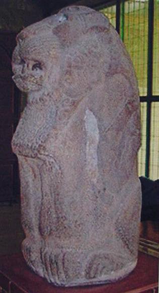
His report is available on the internet please click here to access it, it is an interesting "read" and he shows what Abu Sharein looked like the 1850's and provides drawings of some of the items he excavated at the site including a beautiful basalt stone lion seated on its rear haunches now in the Baghdad Museum. Enki hymns do mention this lion as part of his Abzu/Apsu shrine (it was found by Taylor atop the Abu Shahrein ziggurat mound).
Kramer on the goddess Inanna of Uruk visiting Enki and a banquet he has prepared for her in front of the lion associated with the Abzu shrine (the Ziggurat shrine or Abzu Sea-house, atop the Abu Shahrein mound). She apparently arrived from Uruk (Erech) by boat because after the banquet she returns by boat to Uruk. Upon awakening from his drunken stupor Enki's sukkal (vizier) advises him what he has done, given the me to Inanna who is taking them by boat to Uruk. He tries unsuccessfully to have her stopped and she refuses to surrender them to his servants saying Enki swore by his holy word the me were hers and he is to be despised an oath-breaker. She reaches Uruk and is acclaimed by her people for bringing the forbidden me to their city making it foremost in Sumer as the source of knowledge and wisdom now that the me are in their possession.
"In those days, a young Inanna
to Enki's Abzu in Eridu
set her foot...
Enki, king of the Abzu...
called his sukkal Isimud,
gave him these instructions:
"Come here, my sukkal,
Listen to what I say...
once Inanna enters the Abzu, Eridu,
have her eat butter-cake,
have them pour out for her cold water
that refreshes the heart.
You give her beer to drink in front of the lion,
treat her like a friend...
at the holy table,
the table of An...
she enters the Abzu, Eridu...
she eats butter-cake.
They pour out for her cold water that refreshes the heart.
He gives her beer to drink in front of the lion.
He treats her like a friend..."
(pp. 58-59. "Inanna and Enki: The Transfer of the Arts of Civilization from Eridu to Erech." Samuel Noah Kramer & John Maier. Myths of Enki, The Crafty God. New York & Oxford. Oxford University Press. 1989)
Just think, according to the above myth, the "lady of edin," nin edin (Inanna's epithet at Nippur) acquired forbidden knowledge from Enki in the course of eating "butter cakes" (not a forbidden fruit) while he was in a drunken stupor and distributed this forbidden knowledge to her people and thereby mankind in the presence of the below lion, all this being later reworked as Eve acquiring forbidden knowledge during an act of eating with a man (Adam)!
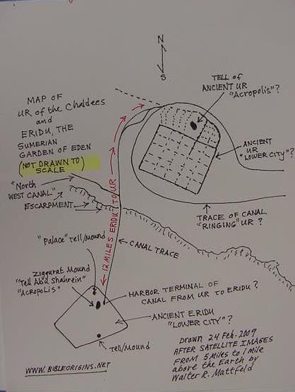
Below my rendering of a map showing ancient Ur and Eridu based on satellite images of 5 miles and 1 mile above the Earth. The distance between the two sites is approximately 12 miles (not drawn to scale). On a clear day standing atop the Ur Ziggurat Eridu's Ziggurat can be seen according to some visitors. I have ben informed by Dr. Collins that Eridu's walls are modern and my "walled lower city of Ur" is modern as well, being an earthen levee wall for an air base.
Of interest in the below satellite photo is the blue-green area about Eridu: This blue-green _surrounds_ the mound of Tell Abu Shahrein and the hillock it sits atop to the north, south east and west. That is to say the blue-green sheen may be sedge grasses (?) evidence that this area still floods at time of highwater (May-July) surrounding Eridu, making of it an island in the midst of the Sebkha. If I am "right" could this be why a highway from Ur to Eridu was built on an artifical levee and why levee walls were constructed about Eridu? Closeup views of the levee highway show the remains of water streams being reflected away, that would normally have penetrated to the west of the levee highway. The same is true of Eridu's modern trapzoidal walls: closeups show streams of water being bounced off the levee walls preventing the SEbkha from flooding the area about tell Abu Sharein. That is to say this area STILL FLOODS yearly in May-June, making Tell Abu Shahrein "an island in the midst of the sea, "the Sebkha. Cf. below the satellite photo of 06 June 2006 showing that the Sebkha is capable of reaching the edges of the depression Eridu lies in, making it an island.
If my interpretations are "wrong" of any of the satellite images posted here, please let me know via e-mail by clicking here and I will be pleased to promptly make corrections to this url. Thanks.
Special Update of 01 March 2009:
I have been advised by Professor Elizabeth Stone of SUNY (The State University of New York) at Stony Brook, who is compiling data on Eridu and trained in the study of satellite imagery that I am wrong, the "canal" going to Ur is not a canal its a "road" to provide access to Tell Abu Shahrein and my "canal-moat" about Eridu is not a canal-moat but a wall (how old the wall is was not stated). I would like to thank Professor Stone and A.S.O.R. (The American School of Archaeology, Boston) for putting the professor in contact with me through their on-line ASOR Blog which accepted my query on the proper identification of Eridu's satellite imagery. Through Professor Stone I was directed to archaeological research revealing that a channel of the Euphrates passed to the south of Eridu and was sporadically active through the 1st millennium B.C.
Note: The satellite images seem to show that a paved "road" does indeed exist atop the east embankment of the levee road going north from Eridu to Ur. Perhaps the Iraqi government created this "road" to facilitate access to Eridu? However, when the end of the road is reached at Eridu's fosse, tire tracks (?) suggest to me one's vehicle must descend from the road into the levee fosse wall then up the western embankment of the fosse and cross over the earthen blockage and then descend into the enclosed area behind the Eridu fosse. This appears to be the _only_ way "into" the area behind the fosse and wall unless one "parachutes in" or arrives by helicopter.
A priest and scribe who serves Enki is asking for the god's help, as he faces ruin and death he makes a passing reference to a "tow path" which may be an allusion to the tow path on a canal from the Euphrates?
"To Enki...to Nudimmud...Never a theft at your sacrifical feasts which I kept faithfully, did I commit...Like the young date-palm planted by the towpath, my branches have not been pared down..."
(pp.96-97. Samuel Noah Kramer & John Maier. Myths of Enki the Crafty God. Oxford. 1989)
Professor Kramer on the me, the totality of knowledge of heaven and earth, reserved to the gods and denied humankind. Inanna will bestow the me on her people at Uruk, to their acclaim, making their city the storehouse of knowledge and of wisdom instead of Eridu (recast as Yahweh-Elohim denying knowledge of good and evil to Adam and Eve, then expelling them after they acquire it). That is to say Inanna's "leaving" Eridu with forbidden knowledge, the me, becomes Adam and Eve's expulsion after acquiring forbidden knowledge and wisdom). Note: Hugo Radau (1911) translated mulu as meaning "lord" and this was a title given Inanna's husband Dumuzi of Uruk, the full title being mulu edin "the lord of edin" while his wife Inanna of Uruk in Sumerian hymns found at Nippur was called nin edin "the lady of edin." I understand Genesis' Adam is a fusion of several Mesopotamian protagonists: (1) Adapa, (2) Enkidu, and (3) Dumuzi, while Eve is a fusion of (1) Shamhat and (2) Inanna.
"...the poet asserts that after human beings had multiplied, Enki brought them forth to his "house" and to his me that were in it, but then took away from the "house" the "me of life," and fastened to his breast other me he had especially sought out. Moreover he then commanded that humankind (mulu) must not covet the me (lines 112-22)..."
"The river has teemed with teeming humankind.
He made them come out to them in the house,
the Master -to his me.
He made them come out to them,
the Master of the Abzu -to his me.
he made them come out to them in the house.
He took away the me of life from the house.
He hunted out,
he hunted out the me,
he fastened them about his chest.
Master he is of the plenteous me:
for his me the mulu must not long.
Enki of the plenteous me:
for his me the mulu must not long.
He must not long -the mulu must not long- for his me.
His command: "The mulu must not long for them."
His order: "The mulu must not long for them."
(pp. 76, 78. "The Enigmatic Enki." Samuel Noah Kramer & John Maier. Myths of Enki, The Crafty God. New York & Oxford. Oxford University Press. 1989)
Kramer on Enki's denying humankind the "me of life":
"Even his role of human benefactor is put in doubt to some extent by his depriving humankind of the me of life..."
(p. 2. Samuel Noah Kramer & John Maier. Myths of Enki, The Crafty God. New York & Oxford. Oxford University Press. 1989)
There is an interesting "paradox" here: Enki (Ea) is portrayed as denying humankind (mulu) forbidden knowledge, the sacred me, and then carelessly giving this knowledge away to humankind!
In the Adapa and the South Wind myth Ea (Enki) allows his servant Adapa of Eridu to learn spells to stop winds from blowing by breaking the wing of the south wind god. This upsets the supreme god Anu (An) in heaven, who has tasked Enki/Ea with the guarding of the me (the "knowledge of heaven and earth") denying them to mankind and the other gods! In the banquet set for Inanna while drunk he gives her the forbidden me. Other texts have him sending fish-men from the Abzu to spread knowledge to humankind which is presented as naked grass-eating beasts of the edin, so that they may become like gods, wearing clothing (knowing it is wrong to be naked like a god), live like a god in cities and till gods' city-gardens, providing the produce for the gods to eat daily at temples. Enki bore the epithet ushumgal meaning "great serpent" or "serpent dragon," and he is responsible for denying Adapa immortality in his later form as Ea of Eridu. That is to say Eden's serpent is ushumgal Enki/Ea and he is Eden's god, Yahweh-Elohim. Eridu, the one place on earth in Sumerian myths where forbidden knowledge is kept (the me) becomes Genesis' Garden in Eden, where access to forbidden knowledge is denied man (adam in Hebrew means "man" or "humankind") by Yahweh-Elohim. Man is not to "long for" forbidden knowledge just as the mulu (humans) are not to long for Enki's me kept at his Abzu shrine or "House of Wisdom" Ziggurat (Tell Abu Shahrein).
Professor Ziolkowski hit the nail on the head:
"Yet what else is civilization but knowledge?...The Yahwist is obsessed with the sin of knowledge."
(p. 22. "Ancient Themes." Theodore Ziolkowski. The Sin of Knowledge: Ancient Themes and Modern Variations. Princeton University Press. 2000)
Kramer's account of Inanna acquring the me for Uruk from Eridu he titled "Inanna and Enki: The Transfer of the Arts of Civilization from Eridu to Erech" (Kramer & Maier.1989:57). This, for me, aligns with Ziolkowski's remark about Civilization being about the "acquistion of knowledge" to better mankind's standard of living. In Mesopotamian thinking man began life an ignorant naked savage beast who wandered the edin with other naked beasts, unaware it was wrong to be naked. The Mesopotamians understood man's lot in life improved when he came to "live like a god," wearing clothes (knowing like a god it is wrong to be naked), caring for the gods' city-gardens, living in houses in cities built by the gods before man's creation. The Hebrews denied all this, life was idyllic for naked ignorant man (Adam) whose beasts were his companions, then came woman, forbidden knowledge, a loss of innocence and expulsion from Paradise.
Georges Contenau understood abzu meant "dwelling of knowledge," (1954:247. Everyday Life in Babylon and Assyria. St. Martin's Press. N.Y.) but Langdon renders ab-zu as zu-ab meaning "nether sea," zu-ab being an ideogram for apsu and as Kramer has pointed out humans (mulu) are not to long for this forbidden knowledge kept in the Abzu house, the knowledge required to make Civilization happen. Man in the beginning in these myths was an animal, naked, eating grass with antelope and wild cattle in the edin, then the gods take him from edin (the uncultivated land about Sumer's cities) and give him the knowledge it is wrong to be naked. He will be the gods' servant and free them of labor for life's necessities: food, shelter and clothing thereby giving them an eternal rest from earthly toil. The gods who at first denied man the knowledge that it was wrong to be naked, give man the forbidden knowledge in order that man can, as their servant, maintain their standard of living: the gods do not want to live like man the beast, going about naked, eating grass for food and lapping water at edin's watering holes with wild beasts, they want clothing to wear, fruits and vegetables to eat from their city gardens, they want houses to live in, domesticated animals for milk, cheese and meat. Only if man is given this forbidden knowledge can he thereby maintain the gods' high standard of living. The gods did not give man forbidden knowledge as an act of love and caring about man, they were looking out for their own self-interests which ignorant humankind could not effectively maintain on their behalf without this knowledge.
Peters (1897) on some scholars identifying Eridu as the Garden of Eden and Eridu's god as recast by the Hebrews into Yahweh-Elohim, notions I am in agreement with from my own research ( brackets [ ] are mine):
"Eridu, which is at least as old as Ur, is represented by the ruins of Nowawis, or Abu Shahrein (father of two months), just visible from the top of the Mughair [Ur's tell mound] on the very edge of the Arabian plateau...Here Ea was worshipped, the god of wisdom, and the father of mankind, whom some would identify as Yah, or Yahweh, the god of the Hebrews. It is with this god that the Babylonian legend of civilization seems to be connected."
(p. 298. Vol.1. John Punnet Peters. Nippur Explorations and Adventures on the Euphrates. Excavations at Nippur. Eleventh Season. New York. G. P. Putnum's and Sons. 1897)
An interesting note: Tell Abu Shahrein of the 1850s by the 1880s was being called Nowawis according to British explorers of the area who noted that the Arabs seemed not to know it as Abu Shahrein which dumbfounded these explorers (How did Shahrein come to be supplanted by Nowawis within a space of 30 years?).
Spoer (1902) on scholars who claimed that Ea of Eridu had been recast into Eden's god Ya, Yah, Yahweh by 1897 and 1898, over 100 years ago:
"Professor Hommel...builds the theory that Ea = Aa, who...is the same as Ya = Yahweh...Margoliouth...identifies Ea...with Yahweh, says that the Israelites received this name from Abraham who came from Ur, in Chaldea..."
(p. 17. note 28: Fritz Hommel: Altisreal, Ueberlieferung, 1897, p. 64; Note 29: George Margoliouth, "Earliest Religion of the Ancient Hebrews." Contemporary Review, October 1898, in Hans H. Spoer. "The Origin and Interpretation of the Tetragrammaton. pp. 9-35. The American Journal of Semitic Languages and Literature. Vol. XVIII. Oct. 1901- July 1902)
One thing which has puzzled me is Leick's observation that the notion of water rising to the earth's surface from an abzu ocean the earth floats upon. She has proposed that the Sebkah east of Tell Abu Shahrein is what is behind the abzu notion. Here, for me, problems begin.
Taylor (1855) stated that in the rainy season the Eridu depression fills with water becoming a sea or lake. The source of this water however was _not_ a rising watertable from under the earth filling hollows. The filling up of the basin was caused by a Wady called Khanega to the southwest of Suq ash Shuyukh that fills with rainwater then bursts, sending a torrent of water into the basin near Eridu. In the Summer this "sea" (Google Earth's map scale suggests the Sebkha or "seasonal lake" is roughly 12 by 8 miles in size) disappears through evaporation and sinking into the watertable. In the "dry" season local nomadic Arabs would dig down into the lower parts of the basin and find brackish or salty water to drink. If there is an abzu concept here it would appear to be that of digging into the earth and finding your pit filling in with water to drink.
Another problem for me: Enki hymns speak of the Abzu shrine casting its shadow over a sea and a reed-filled marshand associated with a flooding river. Is this an allusion to Wadi Khanega's flood waters bursting forth and filling the Sebkah basin east of Eridu? Other wadies to the north, east, west and south of the basin could also contribute run-off waters from rains to fill up the Sebkah east of Eridu.
The hymns mention Enki enjoying punting about in the marsh filled lagoons at Eridu filled with fish, turtles and herons. If the Sebkah is subject to drying up _every_ year how can fish and reeds survive? Only a year round source of freshwater can make this happen.
So perhaps the freshwater from the id nun canal had sluice gates to allow fresh water bearing fish, turtles and reed seedlings to replenish daily the marshes about Eridu? When the id nun canal ceased to be maintained, the area returned back to a Sebkhah which became a lake or sea seasonally in the rainy season with torrents descending from wadies above and ringing the basin on east, west, north, and south sides?
If the Euphrates has enough water to maintain the marshes east of Tell el-Lahm surely it could maintain marshes at Eridu. But if a channel of the Euphrates had moved away from Eridu, the _only_ steady freshwater supply for fish, turtles, reeds and people would have to be the id nun canal.
As regards Eridu's association with the Garden of Eden:
Sayce (1887 and 1908) made this association and it has been endorsed most recently by Leick (2001). I am in agreement with both scholars. Leick suggested that Eridu and Ur were "twin cities," Dynasty III Ur provided funds and labor to maintain the Abzu shrine and priests to conduct its cult activities. A shrine was found dedicated to Enki at Ur suggesting some kind of cult existed at that city too. Abraham, according to some scholars lived at Ur. Professor Kramer suggested perhaps Abraham of Ur was the connecting link to Eridu and Enki, they being recast as Yahweh-Elohim and the Garden of Eden and again I concur. Abraham then lived just 12 miles away from the Mesopotamian precursor of Genesis' "Garden of Eden." It is at Eridu that the Mesopotamians fix the setting for a man (Adapa) being allowed to obtain godly-forbidden knowledge and being denied immortality by Eridu's god as happened to Adam and Eve.
The following is from the Cambridge Ancient HIstory and suggests a wall may have existed in antiquity about Eridu but it had not been found yet and excavated.
"...the city lay on the margin of a desert and was exposed to severe sand storms which, in the end, made the place uninhabitable. But it is evident that in prehistoric times there must have been an abundance of fresh water- the gift of Enki who dwelt in the apsu below the city. Something of this legacy still exists, for in the low-lying ground at the foot of the mound the bedawin can still discover water at a depth of about 6 feet below the surface; this fresh water is known by them as usaila.
Although a near neighbour of Ur, Eridu lay in a different geographical setting, for it was separated from that city by a steep cliff and stood at the southern end of a depression known as the Khor en-Nejeif which becomes a quagmire during the winter and a furnace during the summer. The ruins are visible from afar in the unbroken steppe, both by day and by night under the crystal clear moonlight which illuminates the desert in these latitudes. At dawn the zikkurat stands aloft like a fairy castle for the first half-hour after sunrise, and behind it the mile of camel-thorn, perhaps the source of the legendary Sumerian kishkanu tree, takes on the aspect of a forest."
For a prehistoric site Eridu was an unusually large city...We may estimate that this ancient market town had an area of approximately 20-25 acres and may in the 'Ubaid period have contained a population of not less than 4000 souls. It is also probable that at an early stage in its prehistory it was secured by a town wall, although this remains to be dug in extenso. Traces of canals have been observed in the neighbourhood of the site which in prehistoric times have had direct contact with the main channel of the Euphrates itself although, unlike Ur, it does not seem to have been situated on the riverbank."
(pp. 331- 332. I.E.S. Edwards. Cambridge Ancient History: Prolegomena and Prehistory. Vol.1 No.1. 1970)
Crawford on Eridu:
"...an old course of the Euphrates provided water for both the Ur region and a freshwater lake on whose banks stood a number of sites including the town of Eridu...Eridu covered a total area of between 40 and 45 hectares...Another canal seems to have branched off this and to have run south towards Eridu, without apparently reaching it."
(p. 48. Harriet E.W. Crawford. Sumer and the Sumerians. Cambridge University Press. 1991)
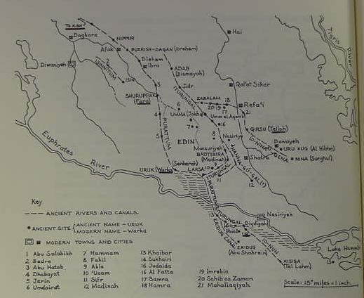
Below, a map showing the principal canals of Lower Mesopotamia (p. 34. Map 2. "Map of Sumer, showing the course of ancient rivers and canals." Lloyd R. Bailey. Noah, the Person and the Story in History and Tradition. University of South Carolina Press. 1989. reproducing a map from Iraq. Volume 26, 1964, Plate XVIII, British School of Archaeology in Iraq). This map shows id nun canal extending southeastwards from Ur (underlined and below Diqdigah) to Kisiga (Tell el Lahm). Note: Zarins' map has Eridu's canal approaching Tell Abu Shahrein from the NW while the below map has the canal passing Tell Abu Shahrein's SW side. Taylor (1855) mentioned a canal 6 yards wide north of Tell Abu Shahrein while Fuad Safar mentioned remains of canal a few kilometers S of the Tell. Only excavations will solve the mystery of where the id nun canal is. The texts suggests it ends at a quay or harbor adjacent to Tell Abu Shahrein.
The depression Eridu lies in has been described as being like a "sea" in the rainy season, receiving rainwater discharges from Wadi Khanega SW of Suk esh-Sheiukh:
"The site of Eridu...nearly in the centre of the dry bed of an inland sea, a deep valley, 15 miles at its broadest, covered for the most part with a nitrous incrustation...In the rainy season this valley becomes a sea flooded by the discharge of the Khanega; in the summer the Arabs dig holes here which supply them with brackish water."
("Eridu." Encyclopedia Britannica. 1911)
Leick on Eridu being on a hillock within a depression twenty feet below the surrounding land (which I assume is the alluvial plain Ur is located upon):
"Eridu is the ancient name of a site now known as Abu Shahrein...the city...was built upon a hillock within a depression about twenty feet below the level of the surrounding land, which allowed the subterranean waters to collect together. This swampy place can still become a sizable lake in the months of high water. The earliest Mesopotamian texts, from the early third millennium, underline the importance of this lagoon. In Sumerian this was known as the Abzu (in Akkadian Apsu).
(pp. 1-3. "Eridu, Creating the First City." Gwendolyn Leick. Mesopotamia: The Invention of the City. London. Penguin Books. 2001, 2002)
Below, a satellite photo showing discharge points of two wadies from the alluvial plain Ur (to the west) and Suq ash Shuyukh (to the east) are on, into the drainage basin Eridu lies in. I have outlined in ink the Sebkha or Seasonal Lake, identified by Leick as the Abzu or Apsu. The "black" area ringed in white within the Sebkha Lake outline shows water still in the Sebkha (the Sebkah was not totally dry when this photo was taken). What I have labeled a canal is a levee road to Ur from Eridu to permit access to the site in the flood season of May, June and July.

Below, a photo of the Eridu Sebkha or "Seasonal Lake" at "high water," filled up by wadies atop the high alluvial plain between Ur and Suq ash Shuyukh discharging copious amounts of fresh rainwater into the basin east of Eridu. This Sebkah is about the size of the Sea of Galilee in Israel. What I find most remarkable in this photo, "_if_" it is of the Eridu Sebkha (?) is that this lake appears to be "almost to the top" of the huge basin that Eridu lies in!
If this be so, then at times of highwater (the rainy season) Eridu became an "island" on its "hillock" surrounded by the Sebkha, in which case the Ziggurat (Enki's Abzu shrine or "Sea House") truely did "cast its shadow over the sea"!
Taylor (1855) noted that the Sebkah was filled via a discharge of freshwater (collected via rain) from Wadi Khanega SW of Suq ash Shuyukh; the satellite photos show two discharge points in this general area. The Sumerians were "wrong" about the Sebkah's (abzu's) source of water being from under the earth (the abzu ocean being what the earth floated upon), it was principably filled by collected rain water from the wadies between Ur and Suq ash Shuyukh as well other wadies surrounding the basin. But when the Sebkah dried up at the end of late summer, by digging into its empty bed, water filled the pits, and apparently it is this phenomenon that is behind the notion of a freshwater ocean being under the earth and creating Eridu's "sea" that Enki's abzu shrine (ziggurat at Tell Abu Shahrein) cast it shade over.
"If" the Sebkhah at times of highwater from rain-fed wadies' disharge could fill up and reach the hillock Eridu is located on. Run-off waters from the high alluvial plain (Leick said Eridu is built on a hillock twenty feet below the surrounding plain) might, in their descent to the Sebkah overwhelm the hillock Eridu is on their way to filling up the Sebkha depression basin east of Eridu. During times of low water, the Sebkha would recede.
Below, some verses suggesting for me that the hillock Eridu was built atop had the basin's seasonal freshwater lake or Sebkah being nearby:
"Eridu, beloved of Enki,
Sea House...
Abzu...
House built on the edge...
Eridu, whose shade stretches over the midst of the sea,
the billowing sea, unrivaled,
the high river, awesome,
that strikes terror in the land,
Sea House, powerful,
noble,
firm-standing
House by the seaside,
a lion in the midst of the Abzu...
your din, like a rising high river,
makes music for Enki...
once Enki had raised up Eridu,
the mazelike mountain floated upon the waters:
at the borders flowing water was held fast
in the reed marshes...
He stood at the Abzu, wonderous to see:
into the Sea House he brought joy,
into the sea put fear,
in the high river created terror."
(pp. 71-72. "Enki and Eridu: The Journey of the Water-god to Nippur." Samuel Noah Kramer & John Maier.
Myths of Enki, the Crafty God. New York & Oxford. Oxford University Press. 1989)
Perhaps "at the borders flowing water held fast in the reed marshes" is referring to run-off in the rainy season from the alluvial plain north of Eridu? The area NW of Eridu suggests to me an ideal location for interconnecting shallow lagoons on the satellite images at 200 feet above the earth. The images suggest dry stream beds connecting numerous pools of standing water in various hollows between the high alluvial plain Ur is on and the modern NW wall of Eridu (and west of the modern canal/road from Eridu to Ur). Below, a mention of Eridu's "interconnecting" lagoons from a story about an egg-stealing turtle and a heron. Please scroll down for a satellite photo taken 06 June 2006 showing three lagoons at high water surrounding Eridu. The large lagoon west of Eridu appears to be draining east into the lagoon east of Eridu. Are these three lagoons the "interconnecting lagoons" of Eridu mentioned in the below hymn:
"...She laid eggs in the wide reed-beds of Tutub. She laid eggs in the marshes of Kiritaba. She laid eggs in the adara thickets of Akcak. She laid eggs in Enki's interconnecting (?) lagoons. She laid eggs in the smaller lagoon, the lagoon of Eridug. She laid eggs in Enki's barbar reeds. She laid eggs in the little zi reeds of Urim. She laid eggs in Urim, where cows and calves abound.
The prince called to his minister, Isimud: "My minister, Isimud, my Sweet Name of Heaven!" "I stand at Enki's service! What is your wish?"...irrigate the outer enclosure (?); and you put ...... (?) Enki's interconnecting (?) lagoons..Isimud ...... paid attention...and he irrigated the outer enclosure (?); and...Enki's interconnecting (?) lagoons. ( Enki speaks:) "Then I, the prince, will make..."
Note: Kramer understood that "the edge" possibly refers to the edge of the e-engura or the Abzu (p. 226. note 25):
"On the edge" may refer to the edge of the engur or of the Abzu..."
Kramer noted that Enki's shrine may be "in" the midst of a sea:
"A shrine Enki erected:
a holy shrine it is, its interior is like a maze;
in [?] the sea a shrine he erected..."
(p. 49. "Enki and Inanna: The Organization of the Earth." Samuel Noah Kramer & John Maier.
Myths of Enki, the Crafty God. New York & Oxford. Oxford University Press. 1989)
Kramer's note on "in":
"Actually there is no "in" (the Sumerian reads a-ab-ba, not a-ab-ba-ka); perhaps therefore it is the sea itself that is the shrine intended in this and the following lines."
I interpret the above verses as possibly being allusions to real physical phenomena which must have occurred frequently some 2500 years ago. The "rising river" probably alludes to the freshwater discharge from wadies (or the Euphrates?) descending into the basin about Eridu's hillock, flood waters engulf the area about the hillock Eridu is on creating marshes. Eridu's "floating upon the waters like a mountain" would be an apt description of someone from the high alluvial shore edge (or atop Ur's ziggurat?) looking south from Ur to behold Eridu's ziggurat (an artifical mountain) seemingly "floating upon" the water engulfed basin like an mountain-island in the midst of the sea. At this photo's "flood-level height" I would expect Eridu on its hillock to be surrounded by this "sea" or lake. The below photo is posted at Google Earth's satellite image at the northeast side near the edge of the huge basin east of Eridu.
The uncultivated land surrounding Sumerian cities was called the edin, which some scholars (cf. German Professor Friedrich Heinrich Delitzsch of Leipzig, 1881) understand became morphed in Genesis into `Eden. The god's city-gardens were at times within city walls as well as outside the walls.
All this is to say the above satellite images of Eridu, are for me, images of "one" of the principal pre-biblical sites that would be recast into Genesis' Garden of Eden. The Garden of Eden has also been called Paradise a word that is Persian and refers to an enclosed (walled) garden or park. The satellite photos of Eridu seem to "fit" the notion of a Paradise, an "enclosed" garden of the gods. To the degree that Sumerian myths make Eridu the world's first city, I understand it is one of the pre-biblical prototypes for the Bible's first city, Enoch, in the land of Nod, built by Adam's son Cain. Please click here for the story.
Please click here for more details on other sites that were fused together to become the Garden of Eden.
Professor Langdon of Oxford University (1921) on Eridu being a possible prototype behind Genesis' Garden of Eden or Paradise (he is commenting on a "Hymn of Eridu"):
"Lines 70-79 certainly contain a reflection of the garden of Paradise which Hebrew tradition actually located in the region of Eridu. The Nippur legend of Paradise does not refer to Eridu and its blissful land but to Dilmun where Enki and his wife ruled in Paradise. Perhaps in the most ancient geography Eridu was included in Dilmun...We know that the temple of Eridu was named Esira as well as Apsu and that the city actually stood beside the Euphrates... Lines 23 and 80 prove that Eridu was actually situated on the Euphrates in the early period. The Sumerian name of the Euphrates, Buranun, "basin of the prince," also proves the prehistoric connection between Enki of Eridu and of the Euphrates."
(pp. 63-64. Stephen Herbert Langdon. "A Hymn of Eridu." Journal of the Society of Oriental Research. Vol. 5. No. 2. October 1921. Chicago)
My note: If Langdon is correct that buranun means "basin of the prince" might this be an allusion to the basin that Eridu lies in (see the satellite photos). Eridu was also called Nun-ki (-ki is a geographical determinative so it probably would not have been pronounced leaving us with Nun as Eridu's ancient name). Enki in hymns is often called Nun "prince," a canal or river called the id Nun "canal of the prince" provides Nun (Eridu) with fresh drinking water. Is buranun then "the basin of the prince"? That is to say the Euprates as the buranun took its name after the "basin" Nun (Eridu) lies in? The river's southernmost channel and "mouth" emptying into the basin of nun gave the stream its name? Strangely Langdon's text does not call Eridu's river buranun, it is called id Zimbir, the "river/canal of Sippar" (line 80, p. 68).
Langdon understood Enki's shrine at Abu Shahrein possessed alternate names including Esira or Esirra (Damkina is Enki's wife)
"The sign...and the variants e-si-ra prove that the well-known temple EI-D-ra commonly read E-engur-ra is E-sir-ra...The value of our text is that it at last furnishes the name of the temple of Ea at Eridu, and that it was also known as Apsu...Esirra of Eridu occurs in King, Magic, 4, 14, Damkina, the queen of Esirra and Marduk is muris Esirra "who causes Esirra to rejoice,"...Nebo is also connected with Esirra of Eridu..."
(p. 67.Note 30. Langdon. 1921)
My note: Is it possible that Arabic has preserved E-sir-ra as Tell Abu Shahrein and Nun as Nowawis and E-engur-ra as Khor en-Nejeif?
Below, Eridu and the Sebkha basin to its east, believed to be the Abzu or Apsu, the freshwater sea or ocean that Eridu cast it shade over in hymns. The photo shows some water remaining in the Sebkah, which looks like a diagonal black streak.
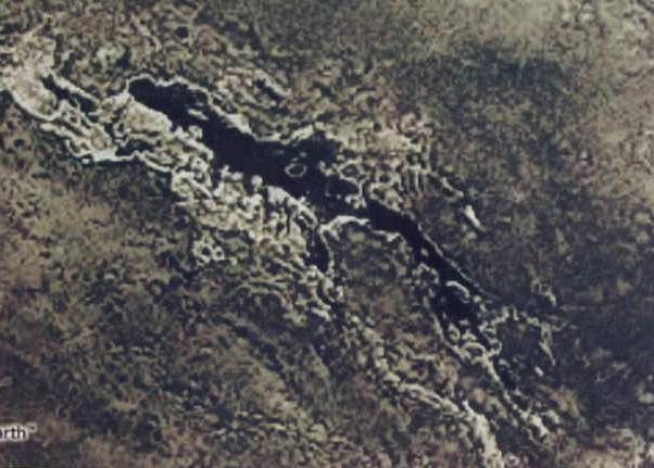
Below, a closeup of the remains (area in black) of the Sebkah, the Abzu, Ap-su, Zu-ab, from the above Visual Earth photo.
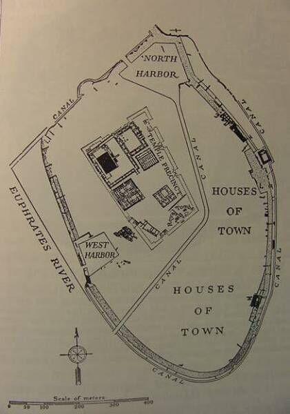
Below, an archaeological map of Tell Abu Shahrein (Shahrain) or ancient Eridu's Abzu/Apsu shrine and ziggurat after excavations by Fuad Safar and Seton Lloyd in 1947-1948 (cf. p. 171. "Eridu, Iraq. Sumerian city circa 5000 B.C." Jacquetta Hawkes. Atlas of Ancient Archaeology. New York. McGraw-Hill Book Company. 1974). Hawkes: "According to Sumerian legend it was the first of the five cities that existed before the Flood...It was served by canals fed from the Euphrates...an ancient reference to Eridu 'on the shore of the sea' probably implies that it stood on a lagoon...The mounds of the ancient city now extend over an area some 1,300 feet by 1,000 feet (approx. 400 x 300 m), and are dominated by the ruins of Ur-Nammu's ziggurat..." 16 August 2009 update: Eridu's stone-lined "quay of the New Moon" or harbor is probably (?) the large opening in the SE wall facing the Ziggurat (viewer's right) on the below site map.
Please click here for a series of satellite photos of the basin that Eridu lies in taken at different seasons of the year showing the basin (Khor el Nejeif) filling with water in March and April, reaching maximum water level at the end of May and early June, then emptying again by December. The 06 June 2006 photo suggests for me the Google Earth photo showing a high water level is of the the Lagoon/Sebkha east of Eridu.
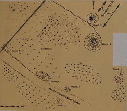
Below, an archaeological site plan of ancient Eridu and its seven mounds as presented by Timothy Kelley of the Massachusetts College of Art: "A Collection of temple reconstructions and site plans at Tell Abu Shahrain." Kelley's map is interactive at his web site and by clicking on mound 1 and on mound 2 plans appear showing various levels of temples and living quarters. Mound 1 (Tell Abu Shahrein) is the largest and earliest mound (observer's right), above it is mound 2 the palace or residence for the temple staff. Mound 3 is below mound 1 and adjacent to the traces of an ancient river bed. Mound 4 is to the left and adjacent to the river bed, mound 5 is to the observer's far right, mound 6 is below mound 3, mound 7 is to observer's far left near the ancient river bed. Mound 5 appears to be the mound appearing in satellite photos near the SE modern levee wall corner (built in the 1980s?) which on my above map is labeled in red ink "a major tell." Please click here to see Kelley's Eridu article and site plans. Taylor who was the first to excavate Eridu said traces of a canal 6 yards wide existed between two tells (north of Tell Abu Shahrain and the administrative quarters), it might be the dotted line (?) between Mound 1 (Shahrain) and mound 2 (administrative quarters) on the below map.
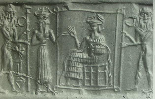
Below, a cylinder seal of Enki (Ea) holding a pot with two streams of freshwater seated in his Abzu/Apsu shrine guarded by two naked men (Lakhmu?) holding stylized gate posts (?). Before him is his two-faced sukkal or vizier Izimud (cf. p. 98. "Ea." Piotr Bienkowski & Alan Millard. Dictionary of the Ancient Near East. Philadelphia. University of Pennsylvania Press. 2000).
Below, a satellite photo taken 06 June 2006 showing the Sebkha east of Eridu at high water, extending to the cliff margins of the Khor el Nejeif depression or basin, suggesting that the above sunset photo truly is of the Sebkha (identified by Leick as being the Abzu/Apsu of Enki texts). It becomes a "sea" at the season of high water from runoffs emptying into the basin
(cf. United States Geographical Survey. Collection: Global Land Survey. GLS 2005. Date: 06 June 2006. Resolution: 240 m.). According to Gaston Maspero (1906) the Euphrates' inundation peaks by the end of May and begins receding after that time. The below photo is taken one week after the peak of the inundation or high water. The flooded Sebkha east of Eridu is probably "the sea" Enki's Abzu shrine (ziggurat) cast its shadow over in ancient hymns, "a sea" associated with flooding rivers. The Sebkha lagoon east of Eridu was called a "sea" which Eridu's ziggurat shrine (modern Tell Abu Shahrein) "cast it shadow over," the "sea" being called the "pure sea" or ab-ba-azag according to Professor Langdon. That is to say, the lagoon east of Eridu was apparently called ab-ba-azag in antiquity. Taylor (1855) said this sea was called the Suleybeea by the Suleyb Arab nomads that frequented the area. Perhaps the term "pure sea" meant it was a freshwater sea (fed by the Euphrates' fresh water) as opposed to a salty sea like the Arabian Gulf (Persian Gulf)?
Taylor (1855) mentioned a tradition among the nomads that the "valley of Abu Shahrein" was once a sea or lake created by the Euphrates river which passed through its length. The below 06 June 2006 satellite photo, if I am reading it rightly, seems to show that the Arabs' traditions were "right." The Euphrates appears to empty into the western end of the great depression west of Abu Shahrein (Eridu) filling it and making it into a small sea or lake. The photo shows what appear to be overflow streams exiting the eastern boundary of this sea/lake/lagoon, heading east and descending south of Eridu to fill up the lower basin east of Eridu, turning it too into another sea/lake/lagoon. At times of high water (late May, early June) when the Euphrates inundation is at its greatest, it would make sense for the local inhabitants to cross the western lagoon by boats from Iraq on the north shore to reach the south shore of the western lagoon and the Nejd which forms the southern border of the western lagoon. That is to say, the satellite photo appears to confirm the 1855 traditions of the nomadic Defyr about a great sea being created by a flooding Euphrates river in the so-called Abu Shahrein valley.
"In conversing with parties of the Dhefyr, who occasionally lodged in my Mutheef, on their way to the encampments of their tribe further inland, they informed me that a tradition prevailing among them, with respect to the valley of Abu Shahrein and the ruins of Qaseyr (further inland), was, that the valley was formerly a sea or lake, connected with the Euphrates (some of them said that the Euphrates ran through it), and that the Qaseyr (small castle), a brick ruin five hours west of Abu Shahrein and situated on the pebbly ridge of the Qassaim, was the "Megdem," or landing place, for boats conveying stores for the towns and villages between it and the "Nejd."
(p. 412. J. E. Taylor "Notes on Abu Shahrein and Tel el Lahm." Read 5th May 1855. pp. 404-415. Journal of the Royal Asiatic Society of Great Britain & Ireland. By Royal Asiatic Society of Great Britain and Ireland. Published by Cambridge University Press for the Royal Asiatic Society, 1855. v. 15)
Below, a satellite photo (29 May 2003) showing _no_ Sebkhas in the Eridu vicinity:
Hammurabi (1792-1750 B.C.) boasted of creating a canal to provide freshwater for irrigation projects at Ur and Eridu:
"Hammurabi has dug the canal [called] 'Hammurabi is the prosperity of the people' -the canal for which [the gods] An and Enlil take care- and thus provided the cities Nippur, Eridu, Ur and Larsa, Uruk and Isin with a steady supply of water for their prosperity and made it possible for the inhabitants of (the lands) Sumer and Akkad, who had been scattered (by war), to return to their settlements."
(p. 87. "The Levant and Mesopotamia." Charles Keith Maisels. Early Civilizations of the World, the formative histories of Egypt, the Levant, Mesopotamia, India and China. London. Routledge. 1999)
Professor Sayce of Oxford University (1887) on the pre-biblical Babylonian equivalent of the Garden of Eden being at or near Eridu:
"The fact that Tammuz was the son of Ea...the god of Eridu...But the primitive home of Tammuz had been that 'garden' of Edin, or Eden, which Babylonian tradition placed in the immediate vicinity of Eridu..."
(pp. 236-238. Archibald Henry Sayce. The Hibbert Lectures 1887: Lectures on the origin and growth of religion as illustrated by the religion of the ancient Babylonians. London. Williams and Norgate. 4th edition, 1897)
Sayce (1908) on Eridu as being the Sumerian equivalent of the Garden of Eden and Adapa (whom he understood could also be rendered as Adamu) of Eridu being recast as Adam:
"Here the first man Adam was supposed to have lived, and have spent his time fishing in the waters of the gulf...Here the first man Adamu had been created in Eridu, "the good city;" and here therefore the Babylonian Semite placed the home of the first ancestor of his race."
(pp. 76 & 91. Archibald Henry Sayce. The Archaeology of the Cuneiform Inscriptions. London. The Society for Promoting Christian Knowledge. 1906. 1908. 2nd Revised Edition)
Sayce (1908) on Eden being derived from Sumerian Edin:
"The Babylonian plain was called by its Sumerian inhabitants the Edin, or "Plain," a name which was borrowed by the Semites and has been made familiar to us by the book of Genesis. Originally it had meant all the uncultivated flats on either side of the Euphrates, but it soon acquired the sense of the country as opposed to the city, and so of the cultivated plain itself."
(p. 78. Archibald Henry Sayce. The Archaeology of the Cuneiform Inscriptions. London. The Society for Promoting Christian Knowledge. 1906. 1908. 2nd Revised Edition)
Professor Clay (1923) on Sayce's identification of Eden with Eridu and Adam with Adapa and Adapa's loss of immortality as borrowed and recast as Adam's "fall" according to some scholars:
"In the past fifty years a number of attempts have been made not only to find Babylonian parallels for the stories of Adam, Eden, and the Fall of Man, but to prove that these stories originated in Babylonian mythology...Another effort was also made to locate Eden at Eridu in Southern Babylonia...The first man, Adam, we are told, was a Sumerian, who had been created in Eridu (the good city); and here, therefore, the Babylonian Semite placed the home of the first ancestor of his race...One of the traditions handed down by the Babylonians, referring to Eridu, is known as the Legend of Adapa, which, although it has very slight resemblance to the story of Adam and his fall, it is claimed, was transformed and recast into that story. Others regard this legend as a direct prototype which had certain influences upon the development of the Genesis story."
(pp. 108-109. "Adam, the Garden of Eden, and the Fall." Albert T. Clay. The Origin of Biblical Traditions, Lectures on Biblical Archaeology. New Haven. Yale University Press. Vol. XII, Yale Oriental Series, Researches. 1923)
Scafi on Dietrich's 2001 and 2002 proposals (Deitrich is a German PhD scholar and a professional Assyriologist like Sayce) on Eridu being the pre-biblical prototype behind Eden's Garden in the Book of Genesis:
"As recently as 2002, Manfred Dietrich proffered his idea, based on a comparison of the Genesis narrative with ancient texts, that the site of the Garden of Eden is at Eridu, in southern Mesopotamia, at the point where fresh river water meets the salt water of the sea (Figure 11.5). Dietrich pointed out that in Eridu there was once a temple dedicated to the Mesopotamian god who created mankind, Enki/Ea, traditionally represented in Mesopotamian art with four rivers. Like Sayce and others before him, he recognized these four rivers as precisely those mentioned in Genesis and whose mouths were in that area. He took his interpretation from a number of texts describing the creation of man in temple gardens and recording environmental changes at the head of the Persian Gulf. In the pairing of the Genesis rivers -the Pishon with the Gihon and the Tigris with the Euphrates- Dietrich also saw an allusion to the oppositon of the two contemporary political powers, Elam and its implacable enemy, Babylon." (p. 351. Scafi)
Scafi's bibliography:
Manfred Dietrich. 'Das biblische Paradies und der babylonische Tempelgarten: Uberlegungen zur Lage des Gartens Eden', in
Das biblische Weltbild und seine altorientalischen Kontexte. edited by Bernd Janowski, Beate Ego, and Annette Kruger. Tubingen: Mohr Siebeck. 2001. Please click here to access Dietrich's article in German. pp. 280-323. Dietrich, 'Der "Garten Eden" und die babylonischen Parkanlagen im Tempelbezirk', in Religiose Landschaften, edited by Johannes Hahn and Christian Ronning. Munster in Westphalia. Ugarit Verlag. 2002. pp. 1-29.
(p. 351. Figure 11.5. Alessandro Scafi. Mapping Paradise, A History of Heaven on Earth. Chicago and London. University of Chicago Press & The British Library, London. 2006)
Conclusions:
(1) The Euphrates does _not_ continue from Tell Abu Shahrein to Tell al Lahm as shown on some maps. It ends in the basin that Eridu is in, terminating in the Sebkha east of and lower than Eridu (rivers do not ascend some 20 feet or more from basins).
(2) Scholars have correctly identified Eridu's Abzu or Apsu as being the Sebkha east of modern Tell Abu Shahrein. This Sebkha is also "the sea" that Enki's Ziggurat shrine cast its shadow over in Sumerian hymns.
(3) The Persian Gulf (Arabian Gulf) was never at Eridu. PhD Scholars (1887-2009), in error, thought Eridu's "sea" mentioned in hymns was referring to the Gulf when in fact the hymns were speaking of the Sebkah which becomes like a "sea" in the rainy season (November-April); it can also become like "a sea" by the end of May due to flooding by the Euphrates.
(4) The id nun canal mentioned in the Enki hymns should "end" in a stone-lined quay or harbor; according to the texts it was lined in "carnelian" in the vicinity of the Tell Abu Sharein mound. So the search for this canal should begin with a careful survey of the area near this mound. At ancient Ur two harbors were identified within the ancient wall encircling the mound of Muqayyar, if the same situation applies for Tell Abu Shahrein then the stone-lined harbor or quay should be a part of Abu Sharein's foundation wall of gypsum stone encircling the mound.
(5) "If" the above sunset (?) photo is of the Eridu Sebkah at high water then it apparently can, at times of extreme flooding, extend to the vicinity of the "hillock" that Eridu is upon (Dr. Collins doubts this photo is of the Eridu Sebkha).
(6) The id nun canal or "canal of the prince" (cf. Leick and Kramer) or id Zimbir "river of Sippar" (Langdon noting that the Euphrates was at times called the "river of Sippar" in various texts) would provide freshwater year round for marshes to exist about Tell Abu Shahrein as mentioned in the Enki hymns and provide fish, turtles, other freshwater creatures, reed seedlings and swamp grasses which would attract migrating birds for nesting like herons as mentioned in ancient texts. When the canal/river (id can mean canal or river) failed to be maintained the freshwater marsh disappeared. No year-round freshwater means no fruit tree orchards and vegetable gardens. The site would have to be abandoned because the seasonal fluctuating levels of the freshwater Sebkha (filled by rainwater runoff from wadies ringing the basin) could not support a year-round occupation.
(7) In agreement with other PhD scholars (Sayce 1887, Langdon 1921, Leick 2001, Dietrich 2002 and others) I understand that Eridu is _one_ of the principal sites (please click here for other sites) that came to be recast in Genesis as the Garden of Eden because it was here that a man (Adapa) was warned "not to eat forbidden food or he would die" presaging God's warning to Adam. It was here that a man (Adapa) was denied by his god (Ea) a chance to obtain immortality for himself and mankind. Here too was where a god (Enki/Ea) kept godly-forbidden knowledge from mankind, the me, having been tasked to do so by An/Anu and Enlil/Ellil (recast in Genesis as God not wanting Adam and Eve to eat of the Tree of Knowledge of Good and Evil which would make them "wise like a God" as noted by Eden's Serpent).
(8) Dr. Collins understands that the perimeter wall about ancient Eridu is a modern feature and not ancient.
(9) For me, it is somewhat amusing that this desolate god-forsaken site in the midst a great basin, described by visitors as a "quagmire" in the rainy season and a "furnace" in the summer (what I would call "a hell-hole"), would be recast as God's lush "Garden _in_ Eden" by the Hebrews:
Genesis 2:8 RSV
"And the Lord God planted a garden _IN_ Eden, in the east: and there he put the man whom he formed."
Eridu's garden according to hymns was situated by the id Zimbir, the "canal/river of Sippar"(Euphrates):
"Its foundation on the nether sea [zu-ab] is filled in.
By the river of Sippar [id Zimbir] it dwells...
O Apsu...
Esira, may the king stand within thee...
Enki, lord of the nether sea [zu-ab]...
Thy quay-wall [kar-zu] is built with carnelian...
Esira of Enki, extended by the pure sea [ab-ba-azag]...
"Eridu of Enki...
to construct the stagetower
'Mountain of the Land'...
Beside it the fish pool was placed.
The beautiful garden was laden with fruit..."
(pp. 67-68, lines 22-39, 68-71. Stephen Herbert Langdon. "A Hymn of Eridu." Journal of the Society of Oriental Research. Vol. 5. No. 2. October 1921. Chicago) Please click here for Langdon's article on "A Hymn of Eridu."
There is one other "final surprise" about Eridu:
The Mesopotamians understood in their myths that it was the FIRST CITY in the world. The Bible claims the FIRST CITY in the world is Enoch in the land of Nod built by Cain the son of Adam and Eve. Thus Eridu is not only a pre-biblical prototype of Genesis' Garden in Eden where a man was warned not to eat or he would die and lost out on a chance to obtain immortality (Ea to Adapa) presaging Yahweh's warning to Adam, it is also the pre-biblical prototype of Cain's city of Enoch in the land of Nod!
Taylor (1855) mentioned in passing that the "valley of Abu Shahrein" flooded yearly becoming a great sea and that traditions of the nomadic Arabs in the area was that boats were used to cross this sea from the north shore (modern Iraq) to the south shore, the edge of the great Najd/Nejd plateau (nejd meaning "high plateau"). Is it possible that Enki at Eridu was via assonance, homophone or homonym confusion mistakenly "morphed" into Enoch and the nearby Najd/Nejd was mistakenly morphed into the land of Nod (nod meaning in Hebrew "to wander"), the Sumerian edin (meaning "back" or the plain "backing," abutting, cities) or alluvial plain between Ur and Eridu being mistakenly morphed into Eden, meaning "delight" (Eridu's north border: Edin/Eden, south border Najd/Nod?
Finally, Ur's king Ur-Nammu, circa 2112-2095 BC who built Eridu's ziggurat may have been a near-contemporary of Abraham of Ur of the Chaldees, some scholars suggesting Abraham lived circa 2100 BC. If so, then Abraham lived just 12 miles away from Eridu where in Mesopotamian myth a man (Adapa) obtained (1) forbidden knowledge, (2) was told not to eat or he would die by his god and (3) denied immortality, themes later associated with the Garden of Eden by Abraham's descendants the Hebrews, Israelites and Jews in the land of Canaan.
The "below" satellite view (2009) shows water (gray areas) "bordering" the SE and SW levee walls surrounding ancient Eridu, revealing that this area in antiquity probably flooded and the levee walls today keep out the water from the Sebkhas at peak flood stage in May, June and July. The ancient tell mound of Eridu is a very faint light circle within the northern levee/perimeter wall. For more satellite photos please click here
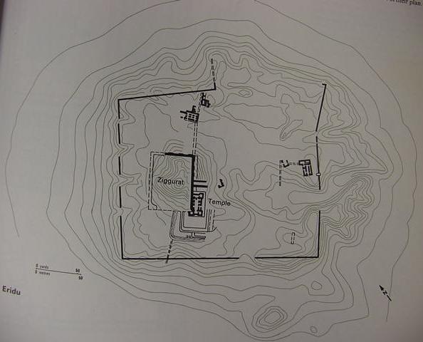
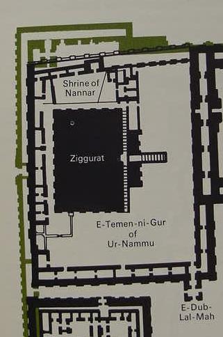
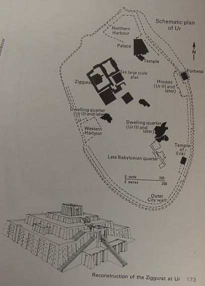
Eridu's ziggurat (Tell Abu Shahrein) is understood from its inscribed bricks to have been erected by Ur-Nammu (circa 2112-2095 BC) a Sumerian king of nearby Ur. Perhaps Eridu's ziggurat was intended to be modeled somewhat after the Ur ziggurat also erected by this same king? If so, cf. below, a drawing of what the Ur ziggurat may have looked like, and, consequently, what Eridu's ziggurat would have looked like too? (cf. p. 173. "Ur, Iraq, Sumerian City, circa 4500-400 BC." Jacquetta Hawkes. Atlas of Ancient Archaeology. New York. McGraw-Hill Book Company. 1974).
Roaf on Ur-Nammu's ziggurats at Ur and Eridu:
"The most impressive monument of his reign was the ziggurat at Ur...The ziggurats built by Ur-Nammu at Ur, Eridu, Uruk and Nippur were the first certain examples of this type of structure."
(p. 100. "Charismatic Kings." Michael Roaf. Cultural Atlas of Mesopotamia and the Ancient Near East. New York. Facts on File. 1990)
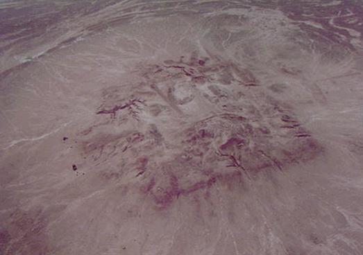
Below, another aerial photo of Tell Abu Shahrein. The remains of the ziggurat are clearly seen as a great mound.
Note: The tell's corner at the "bottom of the photo" is north, the tell's corner at the viewer's right is west.
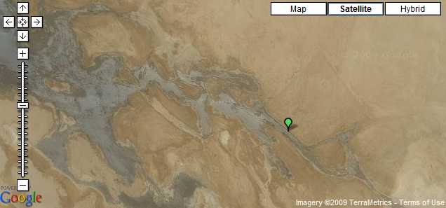
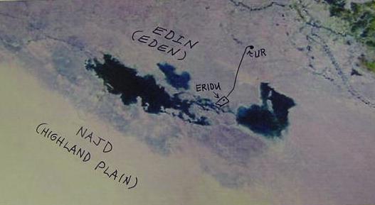
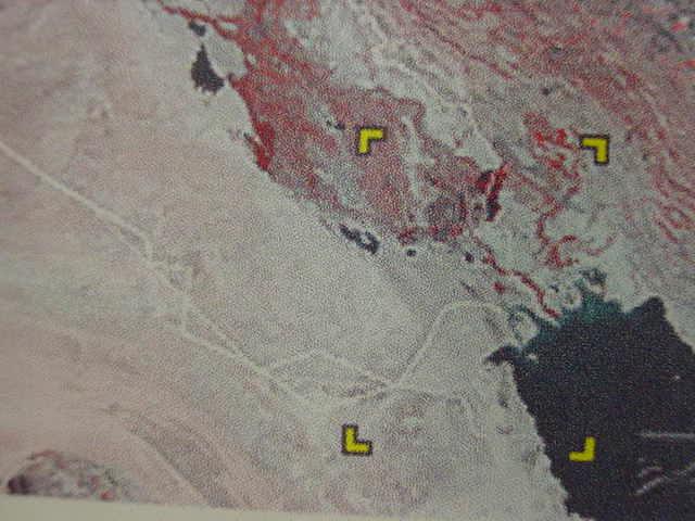
Below, 30 August 1997 (NOAA 14 AVHRR Satellite, U.S. Geological Survey) photo showing the freshwater lake about Eridu almost completely surrounding the ancient site except for a small neck of land or peninsula jutting fom the WNW at whose end lies Eridu. This photo shows the Sebkha at its "greatest maximum in water-level" of all the satellite photos I have found so far on the internet. Three dams, Turkish and Syrian, erected after 1970 have diminished the Euphrates' flow from 30 billion cubic meters of water to 11 billion cubic meters of water reaching Iraq. This no doubt affects how much water reaches today the Eridu basin. Most probably, in antiquity, before the dams were erected, the flooding was more severe and extensive and Eridu's sebkha lake/sea was _much larger_ than modern satellite photos suggest.
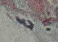
The below 30 Aug. 1997 satellite photo shows that the above 4 sebkhas have merged into 1 Sebkha of huge proportions, a great lake or sea as noted by the Dhefyr nomads in 1855: Ancient Eridu is at the southern tip of the peninsula in the midst of the huge Sebkha which has swallowed up the earlier 4 Sebkhas. Also of interest is that the ancient canal which linked Eridu to Uruk in the Enki hymns appears, from its "angle" to be on the peninsula shown in the below satellite photo (the diagonal dash lines indicating the presence of the seasonal Sebkha in the basin east of Eridu on the map).
Below, satellite photo (24 April 2008) showing ancient Eridu's 4 Sebkhas:
2 Sebkhas West of Eridu and 2 Sebkhas East of Eridu:
Below (06 June 2006) 2 different satellite photos showing 3 Sebkhas, the 2 Sebkhas East of Eridu have merged together into 1 Sebkha with 2 islands in its midst (I have added in ink, the position of Eridu and Ur). The Enki hymns mention "interconnecting lagoons" about Eridu, below is the evidence: 4 lagoons/seas become one.
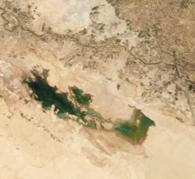
Below, satellite photo (26 March 2009) showing only 1 Sebkha (West of ancient Eridu):
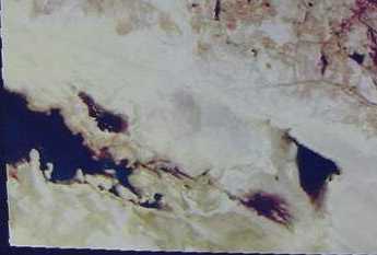
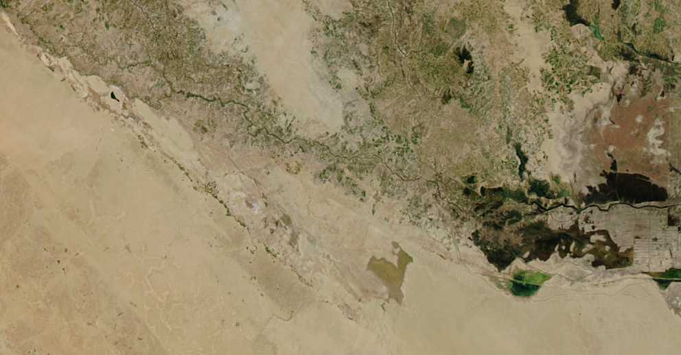
Below, (August? 2004?) 2 Sebkhas merged into 1 Sebkha East of Eridu. The 2 Sebkhas West of Eridu are non-existant (http://veimages.gsfc.nasa.gov/6207/Iraq.A2004039.1010.250m.jpg)
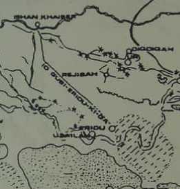
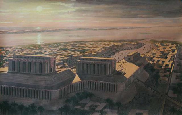
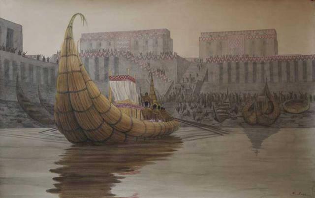
Below, an artist's (Belage's) reconstruction of Eridu and its boat quay, from which Uruk could be reached.
Below, Eridu (by Belage) from another angle, the channel with boats in it is behind the two temples.
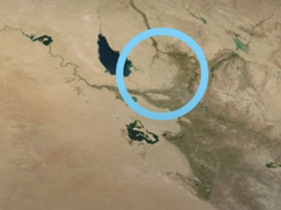
Below, a satellite photo of Eridu's lake (17 Feb. 2017?), the body of water, below the blue circle, being the Eridu vicinity.